|
  |
| Sunday, 24 October 2004 |
| Junior Observer |
| News Business Features Editorial
|
Tipping the balance
The Italian city of Pisa is located about 70 kilometres away from another famous city, Florence. The city was made famous by the tower which is leaning towards the right, but continues to stand without toppling over. Its construction started on August 9, 1173 and went on till 1350. It was built according to a plan of the Italian architect Bonano Pisano to be the bell tower for the cathedral in Pisa's Campo dei Miracoli (Field of Miracles). The tower is 58.4 metres (192 feet) in height and comprises eight storeys. Its walls made of white marble are four metres thick. Its inner walls are made of glossy marble. The circumference of the tower's base is 15.8 metres. Inside the tower, there is a one metre wide spiral staircase consisting of about 300 steps. The reason for the lean is because it is built directly on an ancient riverbed of soft, sandy soil and as the foundation is shallow for a structure weighing 14,500 metric tonnes. The lean of the tower was apparent from the beginning. Although the builders realised this when they completed construction of the third storey, several adjustments were made and construction was completed. The Leaning Tower also gained popularity in the early ages due to an experiment on gravity that Galileo conducted from the tower. The annual measuring of the angle of the lean started in 1918 and it was seen that the lean has increased by over two feet from when the tower was built. The lean was said to increase annually between one to two millimetres. A plumb-line dropped from the top floor would reach land five metres away from the base. Various efforts over the years to stabilise the tower had further increased the tilt. The monument was closed for over 12 years during the nineties so that engineers could work on setting it a little straighter; this project cost over 25 million US Dollars. It included placing 870 metric tonnes of lead weights on the north side of the tower, holding it back with the aid of belts and cables and removing the soil with drills to allow the structure to settle. After these measures, the tower settled back at 39.6cm and now leans at five degrees, slightly straighter than the angle it stood 200 years ago. After the reopening, only about 30 visitors are allowed into the tower at a time so that it would not upset the balance. ##### A reminder of the colonial era To those of you living in the South of the country, the Galle Fort would be a familiar sight.
The Dutch captured the city from the Portuguese in 1640, and expanded and strengthened the Fort and it is their influence and architecture that is most prominent in the Fort today. The Dutch remained for almost 150 years, until the city was taken by the British in 1796. The Fort and its surroundings were declared a World Heritage Site in 1988. The Galle Fort covers an area of 36 hectares and encloses several museums, a clock tower, churches, mosques, a lighthouse, hotels and many private residences. The ancient walls, dating to the Dutch era, are largely intact. The ramparts were built by the Dutch to prevent attacks from Sinhala kings. These are the Star Bastion, Moon Bastion and Sun Bastion. The 20m-high lighthouse, built by the British in 1934, dominates Point Utrecht Bastion at the Fort's south-eastern corner. There are the Triton, Neptune and Clippenburg Bastions, beyond which there is an Army camp at Aeolus Bastion. The real charm of Old Galle lies in the quiet back streets and alleyways of the Fort, which have changed little since colonial times. There are two entries to the fort - the Main Gate, built by the British in 1873 which pierces the main ramparts between the Sun and Moon Bastions, and the Old Gate, further to the east on Baladaksha Mawatha (Customs Road). Just beyond the Old Gate stands the Zwart Bastion (Black Fort) - the oldest fortification surviving in Galle, and thought to be of Portuguese origin. With the exception of Zwart Bastion, the interior of Galle Fort strongly speaks of the Dutch period. Several of the narrow streets still bear Dutch names. Many of the streets are lined with formerly extravagant buildings characterised by large rooms, arched verandahs and windows protected by heavy, wooden-louvered shutters. The northern part of the Fort is dominated by the British-built Clock Tower and a small roundabout located immediately within the Main Gate. The National Cultural Museum and National Maritime Museum are nearby. |
|
| News | Business | Features
| Editorial | Security
| Politics | Produced by Lake House |

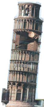 The Leaning Tower of Pisa (La Torre Pendente in Italian) is one of the
most popular and easily recognisable attractions in the world today.
The Leaning Tower of Pisa (La Torre Pendente in Italian) is one of the
most popular and easily recognisable attractions in the world today.
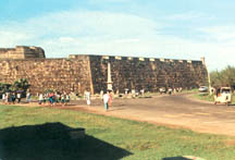 This majestic edifice in the Southern port city of Galle, the largest
fort in the country, was built by the Portuguese in 1587 at Point de Galle,
after they seized control of the town from the Sinhala kings.
This majestic edifice in the Southern port city of Galle, the largest
fort in the country, was built by the Portuguese in 1587 at Point de Galle,
after they seized control of the town from the Sinhala kings.