|
  |
| Sunday, 9 January 2005 |
| Junior Observer |
| News Business Features Editorial
|
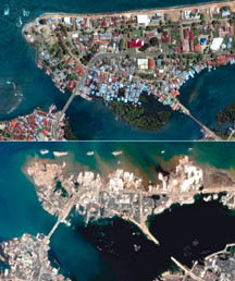
Tracking tsunamis This image obtained on December 28, 2004 from the National Oceanic and Atmospheric Administration (NOAA) shows how the tectonic puzzle pieces fit together around Indonesia.
As the India Plate slides beneath the Burma Plate, it meets pockets of resistance, which causes compressional forces to build up. Weakened overlying rock gets forced upward. Based on the location of aftershocks (red shaded circles on the image), the United States Geological Survey reports that approximately 1,200 kilometres of the plate boundary probably slipped as a result of the quake. The initial rupture was more than 100 kilometres wide, and probably produced an average vertical displacement along the fault plane (the slope along which the two plates meet) of 15 metres. When the bottom of the ocean is deformed by this type of 'megathrust' quake, the upward force acts like a fist rising up from underwater. Water rolls down off the sides of the 'fist' creating massive waves that can travel as fast as an airplane. The waves can move across the ocean and barely disturb the surface, but when they reach shallow coastal water, the earthquake's energy thrusts them tens of metres into the air.
Logistical problems hampered a massive humanitarian relief operation along Asia's devastated shores as the death toll from a huge earthquake and killer tidal waves surged . |
|
| News | Business | Features
| Editorial | Security
| Politics | Produced by Lake House |


 The epicenter of the recent quake is marked with a red star in the
image. It is located just to the east of the Sunda Trench, where the India
Plate begins to get subducted beneath (forced under) the Burma Plate. The
blue arrows along the plate boundary show the direction of subduction.
The epicenter of the recent quake is marked with a red star in the
image. It is located just to the east of the Sunda Trench, where the India
Plate begins to get subducted beneath (forced under) the Burma Plate. The
blue arrows along the plate boundary show the direction of subduction.
 The tsunami created by this earthquake reached India and Sri Lanka in
about four hours. The wave eventually reached Africa, the Pacific Ocean,
Hawaii, and the west coast of North and South America.
The tsunami created by this earthquake reached India and Sri Lanka in
about four hours. The wave eventually reached Africa, the Pacific Ocean,
Hawaii, and the west coast of North and South America.