|
  |
| Sunday, 10 April 2005 |
| Junior Observer |
| News Business Features Editorial
|
Why there was no tsunami in March
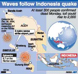
The earthquake was expected to trigger off another tsunami, but fortunately, it didn't happen this time. Although tsunami alerts were issued immediately after the quake, which measured 8.7 on the Richter Scale, no big wave occurred, at least nothing as big as the 10 metres (32.5 feet) high wall of water that caused so much destruction on December 26. Smaller in magnitude The reason, according to seismology experts, could be that the March quake was around 12-15 times smaller in magnitude than the December one. This is crucial, they said, because the bigger the energy released, the greater the chance that the seabed will move. Also, according to the US Geological Survey, this earthquake occurred relatively far below the surface - at a depth of about 30 kilometres (18 miles). It is also unclear whether the seabed was thrust up vertically, which is one of the ideal conditions for making a tsunami. Seismologists believe that the earth must have moved downwards this time, rather than upwards, as it did in December. The upwards jolt created then, caused a vertical displacement of the ocean floor, leading to a tsunami. The quake pushed up the earth beneath the ocean shelf, wedging the Indian Oceanic plate beneath the front edge of Sumatra. This caused enormous pressure which, when released, made the front edge of Sumatra leap upwards by several metres. Meanwhile, seismologists haven't ruled out the risk of a third big quake off the Indonesian island of Sumatra. This particular region is said to have seismic cycles of between 150 and 200 years. The December 26 event however has caused extreme disruption, and a cascade of quakes is now a possibility. "Cascade earthquakes" - a series of earthquakes that decline in magnitude until the tension is eased - are well known in seismology. The 8.7 magnitude quake of March 28 - one of the biggest in a century - came just three months after a 9.0 event further to the north which unleashed the massive tsunami. Subduction zones Both events occurred in subduction zones where plates of the Earth's crust overlap, resulting in bumping and grinding. In this region, the Indian Ocean is sliding beneath Indonesia at the rate of seven centimetres (2.8 inches) a year. As this is not a smooth movement, tension builds up as the plates jam, and when the tension is suddenly and violently released, it results in an earthquake. What increased the tension in March was the energy imparted on December 26. According to seismologists, Indonesia is one of the most seismic parts of the world and this movement has been happening, and is likely to go on, for millions of years. One fault runs under land to the east of the quake region and crosses the northwestern tip of Sumatra, running under the city of Banda Aceh, the capital of the Indonesian province that was badly hit by the previous earthquake. The other fault, Sunda Trench, runs under the sea to the south, parallel to the Sumatra coast, where two fatal tsunamis occurred in 1833 and 1861. Burma microplate The December 26 movement ruptured 250,000 square kilometres (96,500 sq. miles) on a stretch of the Burma microplate, a narrow tongue of the Earth's crust that is jostled by the neighbouring Indian, Australian and Sunda plates. That seabed plunge, by as much as 20 metres (65 feet), triggered the tsunami, killing more than 273,000 people in 11 nations on the northern rim of the Indian Ocean. Part of the energy released by the quake was transferred to the adjacent fault sections. It distorted, compressed and deformed the rock, adding to the burden at known stress points and creating new ones. Meanwhile, in a reassessment of the December 26 earthquake, scientists said the tremor measured 9.3 on the Richter scale. This was more than twice as powerful as originally estimated and the second biggest quake ever recorded. The quake split the ocean floor northward from Sumatra along 1,200 kilometres (750 miles), twice as long as previously thought, according to their research, published in Nature, the weekly British science journal. |
|
| News | Business | Features
| Editorial | Security
| Politics | Produced by Lake House |


 The whole world, especially the Asian countries affected by the
December 26 tsunami, was awake on March 28 when the news got around that
another massive earthquake had taken place in Indonesia.
The whole world, especially the Asian countries affected by the
December 26 tsunami, was awake on March 28 when the news got around that
another massive earthquake had taken place in Indonesia.