Grand Canyon: A natural wonder
If you have heard about the seven natural wonders of the world, you
would definitely know what the Grand Canyon is. The Grand Canyon is a
very colourful gorge (narrow, steep-sided valley), carved by the
Colorado River, in northern Arizona, USA.
It is largely contained within the Grand Canyon National Park - one
of the first national parks in the United States. The Canyon, created by
the Colorado River cutting a channel over millions of years, is about
277 miles (446 km) long, ranges in width from 0.25 to 15 miles (0.5 to
29 kilometres) and attains a depth of more than a mile (1,600 m).
Nearly two billion years of the Earth's history has been exposed, as
the Colorado River and its tributaries cut through layer after layer of
sediment, and as the Colorado Plateaus have uplifted (become raised).
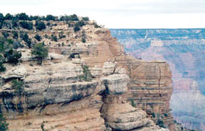
The Grand Canyon is a very deep - in places, over a mile deep - cut
in the Colorado Plateaus that exposes uplifted Proterozoic and Paleozoic
(belonging to ancient eras) strata (layers). The exposed strata are
gradually revealed by the gentle incline beginning at Lee's Ferry and
continuing to Hance Rapid. At the point where the river crosses the
Grand Wash Fault, the Canyon ends.
Uplift associated with mountain building caused by plate tectonics,
later moved these sediments thousands of feet upward and created the
Colorado Plateaus. The higher elevation has also resulted in greater
precipitation (water) in the Colorado River drainage area, but not
enough to change the Grand Canyon area from being semi-arid. Landslides
and other such events then caused headward erosion, which tend to
increase the depth and width of canyons in arid (harsh) environments.
The uplift of the Colorado Plateaus is uneven, resulting in the North
rim of the Grand Canyon, being over a thousand feet (about 300 metres)
higher than the South rim. The fact that the Colorado River flows closer
to the South rim is also explained by this asymmetrical (two sides are
different) uplift.
Almost all runoff from the plateau behind the North rim (which also
gets more rain and snow) flows toward the Grand Canyon, while much of
the runoff on the plateau behind the South rim flows away from the
Canyon (following the general tilt). The result is much greater erosion
and thus faster widening of the Canyon and its tributary canyons, north
of the Colorado River.
Temperatures on the North rim are generally lower than the South rim
because of the greater elevation (8000 feet/2438 metres above sea
level). Heavy snowfall is common during the winter months. Views from
the North rim tend to give a better impression of the expanse (extent)
of the Canyon, rather than the views from the South Rim.
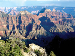
The major geologic exposures in Grand Canyon range in age from the
two billion year old Vishnu Schist, the oldest geological formation
exposed at the bottom of the Inner Gorge, to the 230 million year old
Kaibab Limestone (a layer composed primarily of a sandy limestone with a
layer of sandstone below it) on the rim.
Many of the formations were deposited in warm shallow seas,
near-shore environments (such as beaches), and swamps as the seashore
repeatedly advanced and retreated over the edge of early North America.
Major exceptions include the Cococino Sandstone, which was laid down as
sand dunes in a desert, and several parts of the Supai formation
(composed mainly of shale/a type of stone) that is intermixed with some
small amounts of limestone and capped by sandstone.
The colour of this layer varies from red for the shale, to tan for
the sandstone caps.
The great depth of the Grand Canyon and especially the height of its
strata (most of which formed below sea level) can be attributed to 5000
to 10,000 feet (1500 to 3000 m) of uplift of the Colorado Plateaus,
starting about 65 million years ago (during the Laramide Orogeny). This
uplift has steepened the stream gradient (slope) of the Colorado River
and its tributaries, which in turn has increased their speed and thus
their ability to cut through rock.
The Colorado River basin (of which the Grand Canyon is a part) has
developed in the past 40 million years, and the Grand Canyon itself is
probably less than five to six million years old (with most of the
downcutting occurring in the last two million years). The result of all
this erosion is one of the most complete geologic columns on the planet.
Wetter conditions during ice ages also increased the amount of water in
the Colorado River drainage system. The original Colorado River
responded by cutting its channel faster and deeper.
Then, the base level and course of the Colorado River (or its
ancestral equivalent) changed 5.3 million years ago, when the Gulf of
California opened and lowered the river's base level (its lowest point).
This increased the rate of erosion and cut nearly all of the Grand
Canyon's current depth by 1.2 million years ago. The terraced walls of
the Canyon were created by differential erosion.
A million years ago, volcanic activity (mostly near the western
Canyon area) deposited ash and lava over the area, which at times
completely obstructed the river. These volcanic rocks are the youngest
in the canyon. The Grand Canyon was declared a national monument by the
U.S. government in 1908. |