|
observer |
|
|
|
|
|
OTHER LINKS |

|

|

|
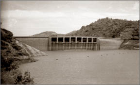
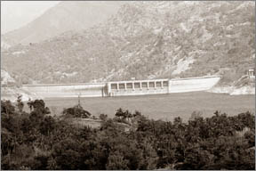
'20 years of Dam site and tunnel geology investigation'Hydropower projects: Prof. W.P. Withanage in retrospect :
With the increasing number of landslides in the hill region of the island, geology has become an important and an interesting subject to study and discuss in Sri Lanka, it was Dr. Ananda Coomaraswamy,the internationally known academician who first did a geological survey in 1906 over a hundred years ago. The undermentioned article comprises extracts taken from a bygone public lecture delivered by Prof. Withanage, viz 2nd Ananda Coomaraswamy Oration 1988, delivered on August 22nd 1988 at the lecture theatre, Department of Geology, University of Peradeniya under the topic and title '20 years of Dam Site and Tunnel Geology Investigations.' The renowned geologist, the late Professor P.W. Withanage who specialised and versed in the science pertaining to geological studies and geoscience though not among the living today, his studies, geological works writing, sketches and all that he said and wrote have remained and are still accepted and embraced by universal literature. Prof. Withanage in his geological studies and works, many years in the past have showed that many reservoirs, canals, dams tunnels, water courses and other hydro-related works in Sri Lanka were not done with a real geological study and learning and standard related to geological science and construction technology. The then politicians pooh-poohed and rejected the facts and data included in that oration enmasse and disregarded its finer points as well. They did not even consider its value bona fide. They threw it away as worthless as a pence on twopence. Unlike the Kotmale Project, many inspections and observations in the Victoria Project were done before planning and without implicit guarantee, noted Prof. Withanage. Anyway as mentioned earlier in other projects here too one portion had been forgotten or ignored i.e. the large crevices, fissures and splits passing through the dam of both sides of the roadway. No geological inspection and geological examinations were held or done. The most fortunate undertaking in my engineering geology career was the detailed geological mapping of the 5 mile/8 km long Polpitiya tunnel along the Kehelgamuwa ridge on the right bank of Maskeliya Oya. The detailed subsurface map of Polpitiya tunnel in 1968 on a scale of 1:120 shows clearly, not only the expected vertical and horizontal fractures, but also that most of these fractures which are normally mapped as joints in surface mapping, show definite vertical movement ranging from a few inches to over 5 ft. It was most interesting to note that the cumulative differential movement along these fractures (over 300) which refers to the Polpitiya tunnel, bottom (invert) level indicated a relative vertical 5 ft. uplift/tilt from the upstream side of the tunnel from the central highlands of Sri Lanka towards the north. This discovery of vertical movements along the fractures exposed along the Polpitiya tunnel walls and along the large surface fractures called lineaments in the Kotmale and Victoria Project areas and elsewhere (tectonic movements) provided first-hand evidence for the vertical uplift of the central Highlands, (so called central peneplain) of Sri Lanka to an anomalous elevation of over 4,000 ft. The youthful topography with waterfalls around Horton Plains (over 6,000 ft) Mountain peaks such as Pidurutalagala (over 8,000 feet) in a very old land surface subjected to weathering and erosion for over 1,000 million years can only be explained by vertical movements along these deep fractures observed in the tunnels and on the surface. Research programmesThese research programmes in the big engineering projects since 1964 by the staff and students of the Department of Geology, University of Peradeniya, have opened up the currently active research programmes on the past and present movements along the lineament fractures (called lineament tectonic). The lineaments cris-cross the whole Island surface and off-shore areas to form a regular mosaic. These tenement studies have a direct bearing on the stability of large dams and powerhouses and leakage from large reservoirs such as Kotmale, Victoria and Randenigala. Lineaments also provide valuable data for the location of potential landslides and subsurface sources of ground water. 'Tunnel is primarily a geologic problem.' Therefore, the design and construction engineer will expect the geologist to locate the most suitable tunnel trace, also to determine the occurrence and size of the fractures and to identify areas of 'bad ground' and seepage zones, that may give rise to tunnel hazards along the tunnel route. In Sri Lanka since 1964 the frequent emergency requests for rescue operation from the contractors, government organisations or their consultants in charge indicate the lack of detailed studies of the land forms (geomorphology) and geology of the local site areas as well as the regional catchment and surrounding area of major engineering projects. This lack of emphasis on delayed investigations of site areas has been the result of the misconceived idea that all regions underlain by old Precambrians Crystalline rocks are stable rectonically. Another factor is the lack of appreciation of currently prevalent special geological and tectonic condition in Sri Lanka - differential tilting and neo-tectonic (recent) movements along deep lineaments and shear zones that may exist in the project areas. Castlereagh -Norton TunnelDuring the excavation of the 20,000 ft. long Castlereagh - North tunnel along the right bank of Kehelgamu Oya, a tributary of Kelani Ganga a highly decomposed and highly sheared Kaolinized shear zone 500 ft (160m) wide was encountered unexpectedly in 1964 near stations 810 ft. (270m) to 1200 ft. (400m) very close to the centreline of the castlereagh dam along the hillside. 'Huge amounts of water started flowing into the tunnel and as the excavation was carried on, new springs were frequently discovered.' The contractors 'feared that the tunnel might collapse or even worse, suddenly would drain the castlereagh lake through a fault zone into the tunnel'. At the request of the contractor in 1964, a detailed geological and geo-technical survey was carried out. Weathered zones and places of potential heavy seepage, from the reservoir were located for further tunnelling. But as expected the tunnelling operations 'Came to a stand still' at station (80m) 250 ft. from the intake on account of badrock 'running ground' and heavy seepage from the reservoir. The completion of the tunnel was delayed by one year resulting heavy losses to the contractor and the government, which had to provide thermal power for one additional year. Detailed field mapping of the tunnel rout and a few more bore-holes across the tunnel track near the intake earlier during the feasibility stage could have located these series of narrow Kaolinized shear zone with seepage and possibly avoided the delay. Laxapana - Polpitiya Project (M.O.P. stage 1)In the case of the Laxapana - Polpitiya tunnel, which runs through the Kehelgamuwa ridge for 25,400 ft. no serious adverse conditions were encountered during tunnelling between 1966-1969. However, the constructional history of the power-house pit or excavation at the end of the penstocks from the outlet of the tunnel was a different story. The siting of the Polpitiya power house excavation is a glaring example of the failure on the part of the consultant geologist (from a foreign country) to observe and interpret the local geology. Although the geology report indicated that the presence of literate over-burden ranging in depth from 75 to 100 feet, the site selected for the power house and the tailrace (outlet for the water from the turbines) was a marsh with peat deposits and boulders along an earlier river channel 60 ft. above the present Maskeliya Oya. The heavy seepage and down slope movement of the landslides and earthslips along the weathered shear zones damaged the construction equipment and delayed the excavation for months. In addition the government of Sri Lanka had to pay Rs. 3,000,000 as damages to the contractor as a result of 'changing conditions.' Canyon - Laxapana Tunnel (MOP Stage II)The 18,500 ft. long unlined pressure tunnel is along the right bank of the Maskeliya Oya, upstream of the Laxapana Power House. In 1970, a detailed geological survey along and across the proposed tunnel route was carried out to determine the feasibility of shifting the tunnel trace towards the Maskeliya Oya to reduce the length of the proposed tunnel and also of the aditus are recommended by the foreign geologists. The new tunnel route No. 3 with only two aditus as recommended on the basis of the results of the detailed geological survey was accepted. On account of the exhaustive study of the geology of the project area, no unexpected tunnelling problems were encountered and the project was completed according to schedule. Maussakalle Canyon Tunnel (MOP III) Kotmale and Victoria Dams and Tunnel During the excavation of the Maussakalle Canyon tunnel extremely adverse tunnelling conditions occurred at stations 660 ft to 12960 ft and nearly 390 ft of tunnel had to be abandoned as a result of wrong selection of the original tunnel trace. InvestigationsIn the case of the Kotmale project a series of investigations by several foreign and local organisations, had been carried out. However, according to the reviewers and panel of experts 'the available knowledge on the geology of the project area is as yet incomplete and is ambiguous and does not permit to enunciate a final judgement.' To rectify these deficiencies the Department of Geology, University of Peradeniya, carried out a detailed regional study of the whole site area. If this detailed survey was carried out earlier, with a careful follow up of subsurface drilling a good deal of money could have been saved during the designing stage. Victoria ProjectUnlike in the Kotmale Project, for the Victoria project considerable preliminary information though deficient in some respects were available during the feasibility and designing stage. However, as in the other projects referred to earlier, no regional study of the geology and tectonic especially along the lineaments around the project site area had been made. In November 1981, during the excavation of a 3 mile long tunnel (22 ft. diameter) extremely adverse tunnelling conditions were encountered at station 15,300 ft. and 300 ft. of old excavated tunnel and partly completed surge shaft were abandoned and the tunnel route relocated on a new trace. Some geologists are of the opinion that a rockfill dam at Victoria would have been more suitable in view of the presence of a lineament through the axis of the tunnel and the reservoir. Need for Seismic and Geodetic MonitoringThe presence of large fractures (Lineaments) showing definite vertical and horizontal shear movements and the occurrence of recent movements in the main project areas strongly indicate the necessity of long-term seismic monitoring and revelling preferably installation of three-dimensional central seismic network. Since recent years, it has become apparent that the impounding of reservoirs large and moderate in size (Victoria and Kotmale are large reservoirs even according to world standards) may induce seismicity even in areas hitherto considered aseismic (Brundsden, 1980). Also 'absence of recent earthquakes strong enough (M 3.5) to be felt does not ensure the absence of currently active faults on the island, which could be triggered by the creation of a large reservoir' (Deere et at Report on Kotmale Project, 1980). As pointed out by Simpson (1986) it is in areas of relatively low natural seismicity that the reservoir induced earthquakes can have their greater impact on engineering design and the largest of induced earthquake has occurred in these areas. e.g. Koyna (6.5) Kariba (5.8) Hsinfengkiang (6.1) and Aswas (5.5). Upto now in Sri Lanka, no increase in microseismicity, important precursor for reservoir induced seismicity earthquake (RIS), has been observed during impounding of the new reservoirs - Victoria (1984) Kotmale (1985) and Randenigala (1986). However, the time-lag of reservoir induced seismicity has varied elsewhere from 5 years (Koyna, India), 7 years (Oroville, USA) to 17 years (Aswas) since the first filling of the reservoir. In addition to seismic monitoring checking of the elevation (re-levelling) around the reservoirs and along the tunnel should be carried out to check the impact of the large volume of water in the reservoir and seasonal draw down on the surrounding terrain at least at 5 year intervals. For this purpose permanent benchmarks should be installed preferably before the impounding of the reservoir. Environment factorsIn addition to the geological factors in selecting the tunnel routes and dam sites, environmental factors should be considered by both engineer and the engineering geologists in charge of the project. 'Not everything technically possible is also ecologically acceptable' (Langer 1982). For this reason, during the selection a tunnel alignment, construction of a dam and impounding of a reservoir, engineering geologists and engineers must be aware of the necessity of taking into account not only of 'factors affecting reliability and efficiency of constructions, but also to a no less extent, the problems of environmental protection and the rational use of the environment.' The State has taken steps during the Mahaweli accelerated programme to mitigate and minimize the environmental hazards. But the drying up of all wells along the 5 mile long unlined Polgolla tunnel and in the case of Kotmale in spite of a detailed geomonphogical survey by a team of experts, the social and economic impact, as a result of the reservoir-induced landslides and creep, on the building and villagers in the 2,000 years old villages, such as Nawangama, Pusulpitiya, Niyangandora, Kalpitiya, Kadadora and Gangewala (covering an area of 4 sq. miles) were not recognised earlier. Recently over 500 families (over 2000 persons) have been vacated from these villages and settled on lands allocated in the neighbouring tea estates. Maintenance of large engineering structuresThe work of the geologist and engineer has not ended when engineering structures, dams, reservoirs, tunnels and power houses are completed. The unlined tunnels such as Polgolla, Bowatenne and Polpitiya require ground inspection periodically after commissioning to check rockfalls and the condition of lined sections. The current repairs undertaken along the Polgolla unlined tunnel show the systematic approach of the newly established department of the Mahaweli Authority Headworks, Administration, Operation and Maintenance (HAOM). However, apart from the routine repairs, the period of dewatering of the tunnel should be made use for installing permanent benchmarks along the tunnel (if benchmarks have not been fixed earlier) and to reveal the invent (bottom) and also the two sides of the lined sections to determine any recent displacements along these weak zones. 'The new technology of large dams is only imperfectly understood.' In Sri Lanka, there are 3 large dams and reservoirs Kotmale, Victoria and Randenigala. Therefore, additional monitoring of these dams as well as the surrounding areas especially on either side of lineament fractures in the site areas should be continued on a long term basis during maintenance. Possible leakage from reservoirs and the effects of rapid draw down and filling are the other important factors that should be monitored. |


|
|

|

|

|

|

|

|

|