Little Blue Birdie’e
Diary Little Blue Birdie’e
DiaryHopping across Sydney Harbour Bridge
Dear Diary,
I’d rather hop than fly during my next journey. Can you guess why?
Let me give you a clue. I’m going to hop like a kangaroo. I hope you got
it right. I’m visiting the land of the kangaroos, Australia.
Last week, when I was thinking about a place to visit, it suddenly
occurred to me that I have never travelled to Australia during all my
travels around the world after I started writing my journal. So, I
thought of flying Down Under this time.
 Since all my friends are still enjoying their holidays, this time
too, I had to make it by myself. I didn’t mind because many of my bird
relations are nested there. So, boarding and food were not problems at
all. They also made my visit a luxurious one. Since all my friends are still enjoying their holidays, this time
too, I had to make it by myself. I didn’t mind because many of my bird
relations are nested there. So, boarding and food were not problems at
all. They also made my visit a luxurious one.
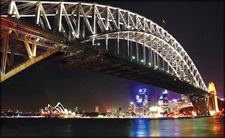
Today I’m visiting the Sydney Harbour Bridge. This is a steel arch
bridge across the Sydney Harbour that carries rail, vehicular, and
pedestrian traffic between the Sydney Central Business District (CBD)
and the North Shore.
As is common for most people, this bridge also has a nickname.
Australian people call it the ‘Coathanger’ because of its arch-based
design, although this usage is less common now than it once was.
The bridge was designed and built by Dorman Long and Co Ltd. Until
1967 this was the city’s tallest structure. According to the Guinness
Book of World Records, it is the world’s widest long-span bridge at 48.8
metres (151.3 feet) width, and is also the tallest steel arch bridge,
measuring 134 metres (429.6 feet) from top to water level. It is also
the fourth longest-spanning arch bridge in the world.
The ends of the bridge are located at Millers Point (in Sydney’s
Rocks area) and Milsons Point (in Sydney’s lower North Shore area). It
carries six lanes of road traffic on its main roadway, two lanes of road
traffic (formerly two tram tracks) and a footpath on its eastern side,
and two railway tracks and a bicycle path along its western side (the
western side is 305 mm larger than the eastern side).
The road across the bridge is known as the Bradfield Highway, and is
about 2.4 km (1.5 miles) long, making it one of the shortest highways in
Australia. Now, you might be wondering what the shortest highway in the
world is. This is the Bradfield Highway found on the Story Bridge in
Brisbane.
The former Bradfield Highway is designated as a Travelling Stock
Route which means that it is permissible to direct livestock across the
bridge, but between midnight and dawn, and after giving notice of
intention to do so.
In practice, due to the high density urban nature of modern Sydney,
and the relocation of abattoirs (places where animals are killed) and
markets, such an event has not taken place for approximately half a
century.
The Sydney Harbour Bridge is not completely stationary. It can rise
or fall up to 18cm depending on whether it is hot or cold. The building
of the bridge is said to have started in 1890, when a royal commission
determined that there was a heavy level of ferry traffic in the Sydney
Harbour area, which could be relieved with the construction of a bridge.
Vehicular access to the north shore was undertaken with a series of
smaller bridges located further westwards in the harbour, but this was
insufficient for the traffic in the Sydney/North Sydney area.
The bridge was formally opened on March 19, 1932. The bridge is also
equipped for tidal flow operation, permitting the direction of traffic
flow on the bridge to be altered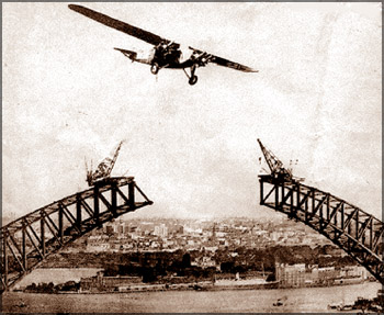 to better suit the morning and evening
rush hours’ traffic patterns. to better suit the morning and evening
rush hours’ traffic patterns.
The bridge has a series of overhead support which indicate the
direction of flow for each traffic lane. A green arrow pointing down to
a traffic lane means the lane is open. A flashing red ‘X’ indicates the
lane is closing, but is not yet in use for traffic travelling in the
other direction.
A red ‘X’ means the lane is in use for oncoming traffic. This
arrangement was introduced in the 1990s, replacing a slow operation
where lane markers were manually moved to mark the centre median(passing
through the middle).
It is reported that in 1943 a flight of 24 RAAF Wirraways flew under
the Sydney Harbour Bridge, with one of the pilots changing his flight
path at the last moment to go over the top of the bridge, only just
clearing it in time.
There is another story of the Americans flying under the Harbour
Bridge, with one Kittyhawk making the flight around February 1942 and
two Kittyhawks doing the manoeuvre in May 1942.
Again in May 1942, the Dutch flew three aircraft of the 18 Squadron
NEI-AF under the Bridge in formation, and then circled back to do
another flight under the bridge. |