|
Natural disasters:
Earthquake
storms?
Earthquakes - a powerful word that sends shivers down one's spine and
causes many to panic, especially those who have been unfortunate victims
of this; one of the world's worst natural disasters. Millions of people
around the world live in fear of earthquakes that cause such havoc and
misery wherever they strike.
Even though our little island has not experienced a devastating
earthquake as such, we have certainly been victims of the destructive
monster an earthquake could trigger off - a tsunami. The entire world
was aghast by the trail of death and destruction the tsunami left in
December 2004, as
 a
result of an earthquake which occurred in the sea off the Island of
Sumatra. Now, even in our country, more attention is paid to earthquakes
that occur in the Asian region, not just to monitor the threat of a
tsunami, but also the possibility of an earthquake that could affect our
country, directly. All this time we were very complacent about the
dangers of earthquakes because our country was not located in the
'earthquake belt.' But now, seismologists and geologists say that new
plates are forming in the region bringing our little island nation, more
closer to an earthquake belt. a
result of an earthquake which occurred in the sea off the Island of
Sumatra. Now, even in our country, more attention is paid to earthquakes
that occur in the Asian region, not just to monitor the threat of a
tsunami, but also the possibility of an earthquake that could affect our
country, directly. All this time we were very complacent about the
dangers of earthquakes because our country was not located in the
'earthquake belt.' But now, seismologists and geologists say that new
plates are forming in the region bringing our little island nation, more
closer to an earthquake belt.
Since, many of you may not be aware of all the scientific details of
earthquakes and what causes them, we'll briefly explain them to you,
later (see Fast facts), but what we like to highlight today is yet
another aspect of earthquakes - a relatively new theory that is still
being researched into.
We like to enlighten you about something called earthquake storms -
yes, sounds strange because we normally don't associate storms with
earthquakes. But - the storms in this connection are not like the usual
storms we are familiar with. So, let's check out as to what exactly an
earthquake storms is.
It is a series of large earthquakes that take place along the same
plate boundary, triggered off by one on the plate.
As we said before, an earthquake storm is a recently proposed theory
that came about following certain observations made by experts in the
field as far back as 1992.
We know by now that earthquakes are unpredictable and no matter how
much sophisticated the monitoring equipment is, no one can predict the
exact time an earthquake would strike. So, serious attempts are being
made the world over to know more about these natural phenomena by
studying earthquakes that have already struck. It was during such
research into an earthquake that took place in 1992 in a town called
Landers in California, that a scientist Dr. Rose Stein came up with a
new theory. Three hours after the Landers earthquake another earthquake
had struck at a place called Big Bear, which is 67 km away from Landers.
Dr. Stein had been of the view that the earthquake at Big Bear was NOT
an aftershock of the earthquake at Landers, but a separate earthquake
triggered off by the one at Landers.
 Stein
believed that when an earthquake occurs the stress that has built up
along the fault, is transferred, in part, along the fault line. Now you
are bound to be confused as to what a fault is, so refer the 'Fast
facts' for clarification. Accordingly, he theorised that it was this
energy transfer that caused other quakes to occur, hours, days or months
after the original earthquake. Stein
believed that when an earthquake occurs the stress that has built up
along the fault, is transferred, in part, along the fault line. Now you
are bound to be confused as to what a fault is, so refer the 'Fast
facts' for clarification. Accordingly, he theorised that it was this
energy transfer that caused other quakes to occur, hours, days or months
after the original earthquake.
Now, since this was something that was yet to be checked out, Stein
and his team had used a computer model which they had already been
working on to study the relationship between earthquakes. The data
collected from the Landers/Big Bear quake had enabled them to create a
model that could predict where the 'stress' from the Landers quake would
have been transferred to. What do you think the result of the
calculations on the computer model was? Just as they theorised; the
stress would have been transferred along the fault line to - Big
Bear.They had then plotted all the subsequent 'aftershocks' and
discovered that virtually all of them had taken place within a high-risk
area the team had labelled as the 'red zone.' Even though this did not
directly prove the theory of an earthquake storm, scientists from around
the world were strongly attracted by this new theory.
And, going by the available data on earthquakes, there was indeed one
part of the world where this theory might just hold true. Where do you
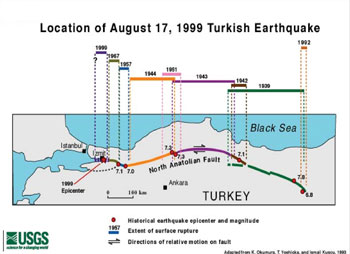
think it was? Turkey.
The cyclic behaviour of the North Anatolian Fault in northern Turkey
had fascinated Professor Geoffrey King. So, he used Dr. Stein and his
team's computer model to study this behaviour; earthquakes in this
particular region moved from east to west with a period of quiet at the
end before the cycle began again.King initially studied an earthquake
that hit the city of Erizican in 1939. Then using available data and the
computer model he discovered that a town called Tokat in the west was
within the red or danger zone. And in 1942, Tokat was hit by a quake.
The model seemed to be working because another town in the red zone,
Adapazari was hit in 1967. It certainly seemed as if the stress was
being transferred to the west. As the quakes were separated by years,
not hours, the possibility of them being 'aftershocks' was ruled
out.What's interesting is that King discovered the next possible point
for an earthquake by using this method. It was a city called Izmit with
a population of about 500,000 people. Even if the earthquake cannot be
prevented, at least buildings could be improved and modified to
withstand the quake and minimise damage and loss of lives. So, the
remarkable news was made public via newspapers, science journals and
other publications. But, unfortunately there wasn't enough time for
action and also not enough of interest from the local community. And was
King right? Yes, tragically. In August 1999, a massive energetic
earthquake, lasting just 45 seconds, struck Izmit, killing over 25,000
people.Going by this theory and using the data from Izmit King plotted
the next possible site. The result caused a great deal of concern
because at the edge of the red zone lay Istanbul a city which is home to
more than four million people. If the earthquake storm theory is right
and King's predications are accurate, Istanbul is in grave danger.
Only time will tell whether this populace city will be hit by an
earthquake or not.
More on earthquakes
next week.
************
Fast facts
What is an earthquake?
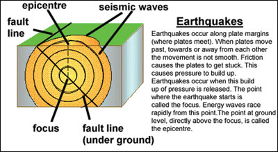
An earthquake is a shaking of the ground caused by the sudden
breaking and movement of large sections (tectonic plates) of the Earth's
rocky outermost crust. The edges of the tectonic plates are marked by
faults (lines of weakness or fractures). Most earthquakes occur along
the fault lines when the plates slide past each other or collide against
each other, when pressure builds up beneath the Earth's crust.Sometimes
tension can be built up for hundreds or thousands of years before it's
released in a great quake.
The shifting masses send out shock waves that may be powerful enough
to alter the surface of the Earth, thrusting up cliffs and opening great
cracks in the ground, that cause great damage.
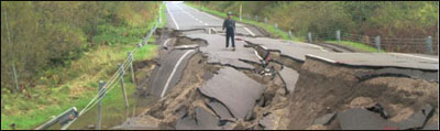
The collapse of buildings and other man-made structures, broken power
and gas lines (and the consequent fire), landslides, snow avalanches,
tsunamis (giant sea waves) and volcanic eruptions, are some of the after
effects of earthquakes.
Earthquake-prone areas like San Francisco and Los Angeles continue to
be at risk from a large quake.
What is an earthquake's epicentre?
It's the scientific name given to the location on the surface of the
Earth that is above the focal point of an earthquake. From this point
the waves of the earthquake radiate outward, like the ripples in a
pond.The Hypocenter is the location below the Earth surface where the
earthquake starts.
Fault or fault plane is the surface area where two blocks of the
Earth suddenly slip past one another. one such place. The San Andreas
Fault stretches about 650 miles (1,050 kilometres) along the California
coast, from San Francisco in the north to the Mojave desert in the
south. There are many such faults all over the world.
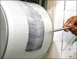
What is the Richter scale?
The Richter Scale (named after Charles F Richter) who developed it in
1935 is used to measure the magnitude of earthquakes. The scale, more
formally known as the Richter magnitude test scale, ranges from 0 to
over 8.0. It is a logarithmic scale, meaning each unit increase on the
scale corresponds to an absolute increase by an order of magnitude, or
factor of 10.
Earthquakes less than about 2 on the Richter scale are meaningless as
they can barely even be measured, much less felt. An earthquake is not
really newsworthy until it hits about 5. At magnitudes of 7.0 or 8.0 the
damage can be catastrophic.
The magnitude of an earthquake (the amount of energy at its point of
origin) is measured using a seismometer. The original Richter scale was
based on a particular sort of seismometer.
Earthquakes cannot be measured very accurately using the Richter
scale when the magnitude is above about 8.3, so a more modern measuring
metric known as the seismic moment is commonly used.
How often do they occur?
Great earthquakes, with a magnitude of 8.0 or greater, happen about
once a year. Smaller earthquakes happen hundreds or thousands of times a
year. Some of these can barely be measured. An earthquake smaller than
3.0 on the Richter scale cannot be felt by most people. The largest
earthquake ever recorded measured 9.5 on the Richter scale, and occurred
in Chile, but caused damage as far away as Hawaii due to tsunamis. The
2004 tsunami was also caused by such an earthquake.
************
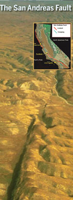 The
San Andreas Fault The
San Andreas Fault
* The average rate of motion across the San Andreas Fault Zone during
the past three million years is 56 mm/yr (2 in/yr). This is about the
same rate at which your fingernails grow. Assuming this rate continues,
scientists project that Los Angeles and San Francisco will be adjacent
to one another in approximately 15 million years.
* The San Andreas fault is NOT a single, continuous fault, but rather
is actually a fault zone made up of many segments. Movement may occur
along any of the many fault segments along the zone at any time. The San
Andreas fault system is more than 1300 km (800 miles) long, and in some
spots is as much as 16 km (10 miles) deep.
* The origin of the name of the San Andreas Fault is often cited as
the San Andreas Lake. However, based on some 1895 and 1908 reports by
geologist A.C. Lawson, who named the fault, the name was actually taken
from the San Andreas Valley. He did not realise at the time that the
fault ran almost the entire length of California!
************ |


