|

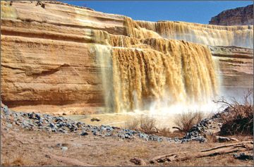
Chocolate Falls or Grand Falls. |
Chocolate Mountains of California |
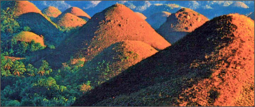
Chocolate Hills : The green grass turn into a chocolate brown
during the dry season |
 |
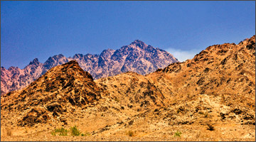
Chocolate Mountains of Arizona |
What comes to your mind the moment you see
this headline? Perhaps little yummy chocolates or chocolate cakes made
in the shape of hills and mountains which you would love to sink your
teeth into, and aconfectionery made with a chocolate drink coming out as
a waterfall?. However, all your mouth- watering yearnings will no doubt
disappear once you look at the pictures because the chocolate hills,
falls and mountains here do not remotely resemble any such thing that is
edible. What we feature today are actual geographical formations you may
be able to see, but not eat, if you ever visit the USA or the
Philippines.
There are two places called the Chocolate Mountains in the USA.One is
located in the Imperial County and Riverside County in the Colorado
Desert in Southern California and the other in the southwestern part of
the state east of the Trigo Mountains and southwest of the Kofa National
Wildlife Refuge in Arizona. Situated about 30 miles apart from each
other these two mountain ranges are not connected to one another at all
.
The Chocolate Mountains of California stretch more than 100
kilometres (60 miles) in a northwest to southwest direction and form the
northeast boundary of the Salton Trough extending as a narrow range some
80 miles (130 km) southeast from the Orocopia Mountains to the Colorado
River valley.The area's close proximity to the Colorado River and the
Arizona Desert contribute to the presence of wildlife species not
commonly found in the California Desert.This mountain range reaches an
elevation of 2,475 feet (754 m) at Mount Barrow, and serves as a
drainage divide for the Salton Watershed to the west.
Even though they are mountains, very little rainfall is experience
here in a normal year, leaving much of the place dry and brown.
Typically about 4-6 inches (100 to 150 mm) of rainfall is experience in
a year. The mean annual temperature is about 60 degrees
Farenheit(16degrees Celsius) to 75 degrees Farenheit (24 degrees
Celsius).
The range is composed of Precambrian basement rocks and Orocopia
Schist with Mesozoic granite intrusions. The mountain range which is
occupied by the Chocolate Mountain Aerial Gunnery Range and is , an
aerial and gunnery practice area used by the US Navy and Marines.
Unfortunately, a large part of the Chocolate Mountains lie within this
gunnery range and are closed to the public. There are two important
wilderness areas located at the southeastern end of the Chocolate
Mountains range named the Little Picacho Wilderness, and the Indian Pass
wilderness.
The Little Picacho Wilderness is a 38,170 acre (154.5 km²) region of
dramatic geological features and habitat that comes under the direction
of the Bureau of Land Management. The preserve has within its boundaries
the southern portion of the Chocolate Mountains. The jutting spires and
steep ridges and ravines which gradually broaden into sandy, tree-lined
washes and slopes and plains without any vegetation are said to be
dramatic in appearance. In fact , the slopes and plains covered with a
desert pavement of angular rusty dark orange and brown coloured cobbles
stand out against the nearly white bottoms of the washes giving the area
its striking topography (physical features of a land area),
The Indian Pass Wilderness Area which is to the north with 32,008
acres (129.53 km2) of open space is a distinctive part of the Chocolate
Mountains, Quartz peak is the highest point in the wilderness capped at
2,200 feet (670 m). The Indian Pass Wilderness preserve is located 50
miles (80 km) west of Brawley, California, and is also managed by the
Bureau of Land Management.
The other Chocolate Mountains is a mountain summit in La Paz County
in the state of Arizona. About 30 miles east of the Chocolate Mountains
of California you come across these famous Chocolate Mountains located
in the southwestern part of the state east of the Trigo Mountains and
southwest of the Kofa National Wildlife Refuge. As we explained before,
the the two Chocolate Mountain ranges are not connected. The range in
Arizona lies in a southwest-northeasterly direction west of Highway 95
on the U.S. Army Yuma Proving Ground. This area is patrolled by the
Military Police from Marine Corps Air Station, Yuma, Arizona.The
Chocolate Mountains of Arizona climbs to 1,030 feet (313.94 metres)
above sea level.
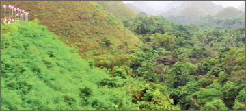
The Chocolate Hills are another facinating geological formation which
is found in Bohol in the Phiippines. Sometimes considered the Eighth
wonder of the World, the Chocolate Hills comprise around 1,268 to 1,776
perfectly coned-shaped or dome-shaped mounds which spread over an area
of more than 50 kilometres of rolling terrain or haycock hills. They are
actually limestone hills covered in grass but as the green grass turn
into a chocolate brown during the dry season, resembling " seemingly
endless rows of chocolate kisses," these hills have been reffered to as
the chocolate hills by everyone. These mounds vary in size from 30
metres to about 50 metres in height with the largest being 120 metres
high. .Scattered throughout the towns of Carmen, Batuan and Sagbayan in
Bohol, these unique mound-shaped hills are Boho'ls main tourist
attraction.In fact, it has been declared the country's third National
Geological monument and has been also proposed for inclusion in the
UNESCO World Heritage List.
The Chocolate Hills and the area around it have relatively flat to
rolling topography with elevation ranges from 100 meters to 500 meters
above sea level. There are various theories put forward regarding the
formation of these hill with some geologist claiming that they are the
result of sub- oceanic volcanismor are simple limestone weathering while
others say they have formed due the uplift of the sea floor.
A more recent proposal is that as an ancient active volcano
self-destructed, it spewed huge blocks of stone which were then covered
with limestone and later thrust forth from the ocean bed .However,
according to a bronze plaque at the viewing deck in Bohol, they are
eroded formations of a type of marine limestone that sits on top of
hardened clay.
The other explanations come from two legends explaining the formation
of the Chocolate Hills. The first legend tells the story of two feuding
giants who hurled rocks, boulders and sand trying to destroy each other.
This fighting lasted days and exhausted the two giants. In their
exhaustion, they forgot about their feud and became friends so that when
they left, they forgot to clean up their mess in the battlefield, hence
the Chocolate HillsThe much more romantic legend tells of a giant named
Arogo who was extremely powerful and youthful. Arogo fell in love with
Aloya who was a simple mortal.
Aloya's death caused Arogo so much pain and misery that in his
sorrow, he could not stop crying. When his tears dried the Chocolate
Hills were formed. Apart from Chocolate Hills there is lso another
geological wonder east
of Flagstaff,in Arizona, on a tributary of the Colorado River is the
Chocolate Falls or Grand Falls. Located just inside the western edge of
the Navajo reservation it is not promoted to tourists and has no signs
pointing to the location from the main highway.
The official name is "Grand Falls of the Little Colorado," but it is
also called the "Chocolate Falls" because of the colour of the water.
This great 'unknown' wonders of Arizona is like a chocolate milk Niagara
Falls. When there is rain or snow, the falls are spectacular. Even when
there isn't much water, they're still beautiful!So if ever you visit any
of these countries try to view these fascinating natural wonders.
Facts and pix: Internet
|


")


