|
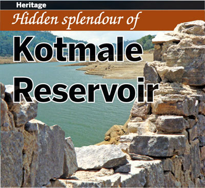
The Kotmale Reservoir which is nestled in the central highlands of
the country between hills is indeed a breathtaking view. When watching
its cool, clear waters ripple in the gentle breeze which blows across
the vast expanse of water, no one would believe that there are many more
things to feast one's eyes on, beneath the tranquil waters. Submerged by
the waters of the reservoir are the ruins of many temples and human
settlements. In fact, more than 14 tea estates, 57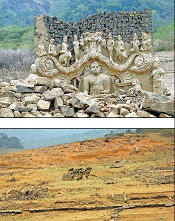 villages and about 54 ancient temples, among others are said to have
gone under water when the reservoir was built. While many of these
places do not exist at present, even underwater, some of them still do.
Among these, the ruins of the Kadadora Vihara are spectacular,
especially the sculptured statues of the Buddha and other deities.
However, they are a rare sight and can only be viewed according to the
whims of the weather gods.
villages and about 54 ancient temples, among others are said to have
gone under water when the reservoir was built. While many of these
places do not exist at present, even underwater, some of them still do.
Among these, the ruins of the Kadadora Vihara are spectacular,
especially the sculptured statues of the Buddha and other deities.
However, they are a rare sight and can only be viewed according to the
whims of the weather gods.
Lying silently under the water, perhaps for years, these ruins which
are a nostalgic reminder of the past life in that area, make their
appearance only during a severe drought. So, when the scorching Sun has
appeased his thirst by drinking up most of the waters of the reservoir,
the remains of the human settlements and the ruins of the temples that
once saw thousands of devotees walk its floors and pay homage at its
altars, slowly emerge, mesmerising those who come to see them. In a
severe drought, the bed of the reservoir sometimes becomes bone dry,
with the earth cracking up to create a striking design on the ground.
Perhaps, some of the villagers whose homes went under water to give
birth to the Kotmale dam, reservoir, tunnel and underground
hydro-electricity power station, then walk on the reservoir bed,
reminiscing the days gone by.
Spread across a land area of 2,270 ha, the Kotmale Reservoir which
embraces lands from both the Kandy and Nuwara Eliya districts, is
nestled between the Tispane and Kadadora hills.
 The
Kotmale Reservoir project was one of the five major projects proposed
under the Accelerated Mahaweli Development Programme, (AMDP) the
country's largest ever hydro power scheme undertaken in ancient and
modern times. Even though preliminary studies were first carried out for
the Kotmale project way back in 1961, and again from 1964 to 1968 by the
government with foreign assistance, the project did not get off the
ground. The
Kotmale Reservoir project was one of the five major projects proposed
under the Accelerated Mahaweli Development Programme, (AMDP) the
country's largest ever hydro power scheme undertaken in ancient and
modern times. Even though preliminary studies were first carried out for
the Kotmale project way back in 1961, and again from 1964 to 1968 by the
government with foreign assistance, the project did not get off the
ground.
Then again another feasibility study was carried out with Indian
assistance from 1973 - 1976. Thereafter, taking into account all the
proposals from all these studies, the green light was given to commence
work in February 1979 under the AMDP. The Kotmale reservoir was to be
built, damming the Kotmale Oya which is one of the main tributaries of
the Mahaweli River. The harvesting of the Mahaweli waters was carried
out with the main aim of generating hydro electrical power to boost the
national grid. And by damming the Kotmale Oya at an elevation of 2,100
feet above sea level, the reservoir which regulates a volume of 174
million cubic metres of water, at full capacity, was formed. The dam was
constructed with three sluice gates which are opened to discharge the
extra waters when the reservoir is at spill level. The crest length of
the dam is about 520 metres and the height is about 87 metres.
The picturesque Kotmale Reservoir was impounded way back in November
1984 and power generation at the hydro-electrical power station
commenced in June 1985. The electricity generated is 206 megawatts.
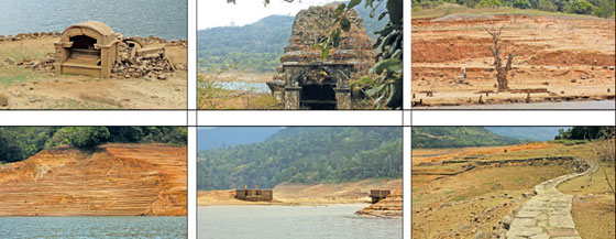
In order to compensate for the number of temples that were submerged
by the waters of the Kotmale Oya impounded for the reservoir, the
authorities laid the foundation stone for the construction of a
magnificent bubble shaped stupa which was second only to the famous
Ruwanveli Maha Seya of Anuradhapura on the right bank of the Kotmale dam
facing the reservoir. The Mahaweli Seya also which is a towering 289
feet in hight, is built at an elevation of 950m (4,150ft) above sea
level. The base of this great seya is 600 metres. Featured here are some
of the spectacular ruins of Kadadora Vihara which are visible only
during the drought season, the Seya and scenic views of the reservoir.
More on Kotmale and other reservoirs later.
************
Fact file
* The Kotmale project is one of five major head works projects
undertaken under the Accelerated Mahaweli Ganga scheme.
* The Kotmale Oya flows through the rural up-country of Sri Lanka
passing ancient villages steeped in history and tea plantations of a
more recent era.
* The rock fill dam created a reservoir having an effective storage
capacity of about 174 m. cm. (141,000 acre feet) enabling regulation of
a large proportion of the recorded mean annual flow of the Kotamale oya
at the dam site.
* The water impounded by the reservoir is conveyed through an
underground water conductor system to an underground power station
located at about 7.2 km. (4.5 miles) from the dam for generation of
electric power. After power generation, is discharged through the
outfall into the Mahaweli Ganga at the Atabage Oya confluence.
* About 3000 families lost their homes and lands due to the
construction of the reservoir.
* The catchment area of the river at the dam site is 730 sq.miles.
*The drainage area of the reservoir is situated in the central hills
ranging up to about 8,000 ft.
*The Dam Crest Length is 520 m and the dam height 87m.
* The Mahaweli Maha Seya is built on the right bank hill above the
dam site at an elevation of 950 m (4150 ft.) above MSL ie. It overlooks
the dam site from a place 257m (845 ft.) above. It consists of a 200 ft.
(61,0 m) diameter and 11inch thick reinforced concrete shell, which
supports a square chamber (31 ft.)a Dewatha Kotuwa (12 ft), a pinnacle
44(ft) and a Kothderella (52 ft) respectively. The overall height of the
structure is 274 ft. (83ft ) |


")
