New ARRIVALS
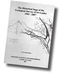
The Historical Saga of the Geological Survey of Sri Lanka 1903-2007
The Historical Saga of the Geological Survey of Sri Lanka traces the
history of the development for the systematic search for minerals of
highest economic value in the island.
The forerunner was the Mineral Survey of Ceylon established under the
colonial rule by the British in 1903. Dr. Ananda Kentish Coomaraswamy
came to be appointed as the first Director of the Mineralogical Survey.
He served from 1903-1906.
 |
|
Author: L. K.
Seneviratne
Published by Geological Survey and
Mines Bureau |
The initial objectives were to search for and explore the economic
minerals of the island, to provide advice to the Government for their
further development and to prepare papers descriptive of the geology and
mineral resources and to collect and arrange geological specimens with a
duplicate series reserved for exhibition at the Imperial Institute.
The time given for the task to cover the entire island was three
years, later extended to six years. The formidable task foresaw the
necessity to establish a Geological Survey, to appoint a permanent
Geologist and Mineralogist and to discontinue all mineralogical work.
The vicissitudes that affected the survey in its evolutionary stages
are reflected in the changes of its location, the administrative
composition and functional aspects that catered to the national needs,
the discipline, and in conformity with allied and similar world
organisations.
The decade of the 1950's saw the publication of the Provisional
Geological Map of Sri Lanka, the commencement of 1" to 1 mile scale
geological mapping, geophysical survey of the Island and commencement of
diamond drilling in geologic investigations.
In the 1960 survey for nuclear raw material was initiated. The
expansion of laboratory services included the installation of the
Spectrographic Laboratory in keeping with worldwide similar institutes.
The quarter inch Tectonic Map was another landmark in the survey that
resulted from the aerial photographic cover of Sri Lanka in the '50s.
The highlights in the 70s record the initiation of the Geophysical
Survey of the Island a programme directed towards the mineral and ground
water exploration and the Gravity Anomaly Map of Sri Lanka was published
in 1972. The discovery of the 'Rock Phosphate' deposit was also in 1972.
Dr. H.P. Wijayananda, the 1st director of the newly instituted GSMB
had the mandated task of carrying out prescribed functions requiring
upgrading of all divisions, the acquisition of up to date modern new
technological facilities for the speedy, accurate and qualitative output
and the expedient functioning of delegated divisions.
Another milestone is the Institution of the Saismological Base and
Program and the installation of the Station at Pallekelle connected to
the Global Seismological Network maintained by Incorporated Research
Institution for Saismology (IRIS) and the Project International
Deployment of Accelerometers (IDA) of the University of California.
A final report on tsunami Vulnerability Program (TVM) was compiled
based on the investigations and an inundation map was prepared. The
input of data into the (CDF/ISIS) WINISIS library catalogue is a
significant step facilitating users for access to on-line catalogue for
text books available at the GSMB Library.
This Saga which has its beginning in 1903 concludes in 2007 with the
emphasis on the very basic necessity of systematic gelogical survey of
our terrestrial and marine domain identified from historical times to
present day is the vital base for understanding the terrain and its
environment both physically and biologically in all its diverse forms.
|

