Jaffna revisited
By Jayantha Jayewardene
I have gone to Jaffna three times. My first visit to Jaffna was in
1956 when my parents took my brother and myself to Jaffna. The second
visit was when the late Gamini Dissanayake took a team of Mahaweli
agronomists, for a week, to study the agricultural practices in the
Jaffna peninsula. The third visit was at the beginning of June this
year, when we went to carry out a schools awareness program.
|
Island of Hammenheil |
On my first visit we drove to Jaffna from Kandy. I was then 12 years.
I don't remember much of that visit but do remember the Casuarina Beach,
vast stretches of cultivations of vegetables, the unique method of
drawing water for agriculture from a well, and little else. However, one
thing stands out in my mind. When we got to the Chavakachcheri
Rest-house, where we were to stay the night, the Rest-house Keeper asked
whether we would like chicken curry for dinner. On getting the yes from
my father, the Rest-house Keeper proceeded to take a gun, went out to a
thicket not far from the rest-house and shot a jungle fowl which was
there. He cooked it as a curry for dinner.
Routes
There are two routes to Jaffna from Anuradhapura, that one can use.
One is from Anuradhapura via Medawachchiya-Vavunia-Kilinochchi-Elephant
Pass to Jaffna. The alternate route is through Mannar. There are three
routes along which you could approach Mannar. One is from Medawachchiya-
Neeriyankulam and then Mannar. The second is from
Nochchiyagama-Tantrimale-onto the Mannar-Medawachchiya road and on to
Mannar. The third is from Puttalam-Eluwankulam- through the Wilpattu
National Park- Silavathurai-Murunkan and Mannar. The shortest route to
Mannar, from Colombo, is through Wilpattu.
From Mannar you take the new road to Pooneryn and across the newly
constructed causeway direct to Jaffna. This road has been reconstructed
recently though there are about two or three kilometres yet to be
completed.
The road to Pooneryn runs, for about two or three kilometres, through
the Madhu Road sanctuary and has a preponderance of Palu (Manilkaras
hexandra) or Ironwood trees. The road is lined with these Palu trees and
when I passed recently the Palu was in fruit. A new feature seen on the
Jaffna - Pooneryn road are sign boards that show that you are leaving a
particular town or village. The board has the name of the place in all
three languages but has a white line diagonally across the board.
Schools
We carried out a schools awareness program in eight schools in the
peninsula. The schools were Jaffna Hindu College, St John's College,
Jaffna Central College, Jaffna Hindu Ladies, Mahajana College and Union
College (both in Tellippalai), Hartley College and Nelliady Central
College (both in Nelliady). Our program was designed to create an
awareness on Sri Lanka's biodiversity, the natural environment,
pollution, wildlife, evolution etc. amongst the children.
I was impressed by the dedication shown by the Principals and
teachers of these schools, to keep to their task of giving their
students an all round education in a conducive environment. Their
enthusiasm to learn and the discipline of the students was exemplary.
Most of these schools, especially those started by the Christian
missionaries, have had strong traditions which the schools are striving
to maintain.
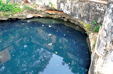
Nilavarai Deep Well
The Nilavarai well located at Nawathkiri, on the Kankasenturai road,
is a very deep well where the actual depth has not been ascertained,
despite many attempts to do so.
The local information is that the first 40 feet of the well is fresh
water and further down turns saline. It is reputed that there is an
underground tunnel which leads to the sea. Tourist brochures describe
the well as 'a beautiful natural well with an astonishing aquamarine
colour. What there now is a dirty water hole, which is polluted and of
no use to even bathe. However, the mystery of its depth and source of
water continues. Some think that this well is connected to the ponds at
Keerimalai.
Jaffna Fort
The Jaffna Fort was built by the Portuguese in 1618, when they
captured Jaffna. It was subsequently captured by the Dutch in 1658 after
a three-month seige. The Dutch demolished the damaged and out of date
square fort of the Portuguese and in its place built their ideal
fortress. The Dutch added to the fort and made it bigger.
|
The Dagobas at Kantharodai |
This is the only large military fort in the country. The Jaffna Fort,
the second largest Dutch Fort in Sri Lanka, is located immediately south
of Jaffna town, with the southern side bounded by the shallow waters of
Jaffna lagoon, the inlet of the Indian Ocean that carves out the Jaffna
Peninsula. There are five outlets to the sea from the Jaffna lagoon, the
biggest being the one between Karainagar and Kayts.
The Dutch first built the inner pentagon, and the main gate here
bears the date of 1680 and then in the following century enclosed it in
a wider fortification of the same shape. This shape is not as obvious as
three of the branches are not built because of the vicinity of the sea
on these sides.
The fort's black coral-lined walls, ramparts and battlements stand
high on the grass covered mound and are surrounded by a moat. The fort
covers an area of 22 hectares, a beautiful setting and rightfully
qualified as a Citadel (i.e. a large, independent, garrisoned,
administrative and military centre without civil inhabitants).
The fort remained with the British till 1948 when independence was
declared.
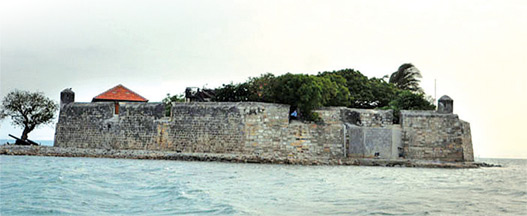
Fort Hammenheil
This small fort stands, off Karainagar, on a rocky island at the
entrance to Jaffna lagoon. The fort was constructed by the Portuguese in
1618 and takes up all the limited land of the island. The Portuguese
named it Fortaleza do caes. The walls are made of large chunks of coral
and bound by a mixture that also seemed to include burnt coral. This
fort was in the north and the Mannar fort in the south and the two
served to guard the passage, by water, to the Castle Fort at Jaffna.
This fort is built in an unusual circular design and has two internal
levels. The fort stands on a small sand bank between the small islands
of Karaitivu and Velanai (Kayts) and the sole navigation channel from
the sea to the lagoon on which Jaffna stands.
This island fort was captured by the Dutch in March 1658. They
changed its name to Hammenhiel (heel of the ham). The shape of Sri Lanka
reminded the Dutch of a leg of ham. When the Dutch occupied this
water-fort, they found that the sand bank on which it was built had been
undermined by the storms of the North-East monsoon.
They remedied this erosion by piling up a breakwater of stones.
A low vaulted gate-way not more than seven feet in height is the only
entrance to this fort. The living quarters consist of three or four
rooms in the courtyard. The vaults under the ramparts were doubtless
used as a store rooms.
One of the cells where the foreign invaders kept their prisoners was
also used by our security forces, during the 1971 JVP insurrection to
keep leader Wijeweera locked up after his arrest.
The Sri Lanka Navy has now converted this fort to an up market hotel.
The living quarter of the Portuguese and Dutch soldiers, four rooms
in all, have now been converted to hotel rooms. The food and other
facilities are on the mainland. The fort surrendered without resistance
to the British in 1795 and in 1948 became the property of the
independent government of Sri Lanka.
Nallur Kandhaswami Kovil
Nallur Kandhaswami Kovil, is located 3km from the town centre. It is
dedicated to the Hindu God Murugan and was rebuilt in 1807 during the
British occupation.
The original shrine, a devala featuring the statues of Hindu Gods and
Buddha, built by the Prince Sapumal of the Kotte Kingdom and the vice
royal of Jaffna Peninsula, was destroyed by the Portuguese, on February
2, 1625. To date at the Nallur Kandhaswami Kovil, prayers are recited in
the name of Prince Sapumal of Kotte.
The Nallur Kovil has been built four times. The first three being
destroyed by invaders, with the third destroyed by the Portuguese. The
fourth, the present temple, was constructed in 1749 A.D. during the
Dutch era. The present temple is now in the premises of the original
temple.
Today the Kovil has developed into an enormous complex encompassing
numerous shrines accessed by richly decorated corridors. Within the
complex are a beautiful courtyard and a large tank.
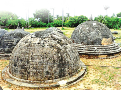
Dagobas
Kantharodai, described as Kadurugoda Temple in the Sinhalese
chronicles, is a 3rd century BC Buddhist site located about 10km north
of the city of Jaffna, and closer to Chunnakam.
Kantharodai consists of a cluster of twenty miniature dagobas,
ranging in height from one to three metres. It is believed that each of
the miniature dagobas has the remains of bhikkhus enshrined therein.
These dagabos are somewhat akin to the stupas at the Borabadhur
temple in Indonesia.
|
The well at Nilavarai |
Sir Paul Pieris who discovered the site in 1916 wrote that "Kantarodai
appears to me to be a miniature Anuradhapura buried in the Tamil
country". Some suggest that Kantharodai marks the spot where Buddha
landed on his second visit to the island.
The finials of the stupas are made of limestone. A sacred footprint
stone was also found on the site. This has been identified as the
Kadurugoda Temple as mentioned in the Sinhala Chronicles, its history
dating back to the third century BC. This site does not seem to be
getting the attention, from the Department of Archaeology, it deserves.
Point Pedro
The light house at the coastal village of Point Pedro marks the
northern most point of Sri Lanka and faces the Bay of Bengal.
The name of the place is derived from the Portuguese Punta das Pedras
which means Stony or Rocky Point.
The distance across Sri Lanka from Dondra head in the south to Point
Pedro is 435 kilometres.
The breadth of Sri Lanka is 224 kilometres, this distance being
calculated from Colombo to Sangaman Kanda in Komari, which is north of
Pottuvil.
West of Point Pedro is the infamous coastal village of Velvettiturai,
which for decades, had been a stronghold of the petty local smugglers
and the landing point of illegal immigrants or Kallathoni's from South
India.
- [email protected] |


")
