
Magical Mullaitivu!
Mullaitivu is a tiny town in the
north-eastern coast of Sri Lanka. It is the main town of the Mullaitivu
District in the Northern Province of Sri Lanka. A largely fishing
settlement, the town in the early 20th century grew as an anchoring
harbour of the small sailing vessels transporting goods between Colombo
and Jaffna. The town has a District secretariat, many other government
institutions and schools.
The town was an LTTE-controlled area, with the Tigers having a large
military base in the town and has been the theatre of many battles
fought since 1983 in Sri Lanka’s war against terrorism. It was damaged
by the 2004 Indian Ocean tsunami with much loss of life.
The Sri Lankan Army took control of the town on January 25, 2009, in
the Battle of Mullaitivu in its offensive against the LTTE.
 Mullaitivu District is one of the newly created districts in Sri
Lanka in 1979. The district occupies the Eastern part of the mainland of
the Northern Province. The Mullaitivu district has the Kilinochchi
district on its northern border, Trincomalee district and Vavuniya
district and part of the Mannar district in the south, Mannar district
in the west and the sea in the East. It covers a land area of
approximately 2,516.9 sq.km. (including the forest area excluding larger
inland water). This district accounts for 3.8 percent of the country’s
total area. The Mullaitivu district is flat land, generally sloping to
the East and North, in the Western part, towards West and South. Mullaitivu District is one of the newly created districts in Sri
Lanka in 1979. The district occupies the Eastern part of the mainland of
the Northern Province. The Mullaitivu district has the Kilinochchi
district on its northern border, Trincomalee district and Vavuniya
district and part of the Mannar district in the south, Mannar district
in the west and the sea in the East. It covers a land area of
approximately 2,516.9 sq.km. (including the forest area excluding larger
inland water). This district accounts for 3.8 percent of the country’s
total area. The Mullaitivu district is flat land, generally sloping to
the East and North, in the Western part, towards West and South.
This district has 70km of coastal belt and four lagoons of Kokkulai,
Nayaru, Nanthikadal and Mathalan with high potential for prawn culture.
The elevation varies from sea level to 36.5 metres. Major soil groups
are reddish brown earth and red yellow lato soils which are suitable for
cultivation.
This district consists of different eco-systems as forest land, shrub
land, coconut plantations, agriculture lands and water bodies.
Approximately 167,850 hectares which is 64.1 percent of the total land
area consists of forest, agriculture covers nearly 44,040 hectares (16.9
percent), range land accounts for 13,650 hectares (5.2 percent) another
26,150 hectares constitute of water and homestead and build up land
accounts for 5.1 percent.
The Mullaitivu district is in the dry zone of Sri Lanka having a
bimodal rainfall pattern.
The district receives most of the rain during the North-East monsoon,
from early October to late January. The annual temperature is low during
October to January and there being significant fluctuation between day
and night temperatures.
This district is bestowed with water resources, which could be used
for agriculture development.
The district has five administrative divisions and covers 127 Grama
Niladhari divisions of Maritimepattu, Puthukkudiyiruppu, Oddusuddan,
Thunukkai and Manthai East and 620 villages. The estimated population in
this district was 220,311 as at December 31, 2007.
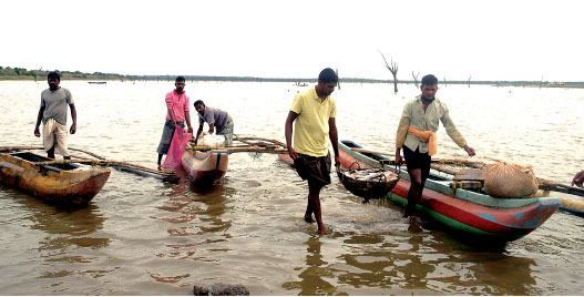
The major portion of the population is engaged in Agriculture sector
which includes fishing and livestock, other occupations are in the
industrial sector, Government sector and private establishments. Nearly
19,416 and 3,612 families are engaged in agriculture and fishing. The
Government has allocated Rs. 1,000 million for development projects last
year. |


")
