Kuchchaveli fears unfounded - Geologists
By Mohammed NAALIR Reporting from Kuchchaveli
|
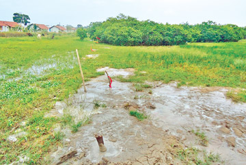
The marshy land, This is the main site the geologists are
engaged in surveying.
|
Salappai Aru, a fisheries hamlet occupied by tsunami affected
fishermen, close to Kuchchaveli town along the Eastern coastal belt in
the Trincomalee district was in the news a few days ago after water
gushed out from a fissure in a marshy land.
It is not related to the two seismic events that took place the same
day (January 22) near Indonesia, geologists said, allaying fears that
the Kuchchaveli incident could have been a quake or tremor.
A nine-years-old girl who was buried in a mud pit created by the
fissure was saved by the security forces and villagers.
A team of geologists let by senior geologist, Dr. Sterling Fernando
is exploring the reason for such occurrences at the site. This team of
geologists and mine experts had visited the site following this
incident. The incident took place in a 400 metre long stretch according
to a rough estimate.
Geological Survey and Mines Bureau Director General S.M.A.T.B.
Mudunkotuwa said he would issue a more detailed statement after
receiving the final report of the geologists at the site.
Dr. Fernando described the site as a sedimentary basin. According to
him the top layer is very hard, the layer below it is soft and the layer
beneath that is hard.
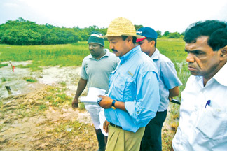
Geologist Fernando with the team
|
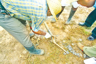
The soil being checked by experts. |
He said that they drilled down to 20 feet upto the aquifer layer -
the fresh water layer. He said that water comes to the surface through
the weak soft layer of the soil. That is what is happening in Salappai
Aru.
They have found a layer with clay and water at this site. There are
fluid 'lenses' in the soft layer. It is not water or solid material, but
a fluid like cement clay. An aquifer layer lies below the sedimentary
basin. When the area experienced heavy rains the aquifer would have come
out due to pressure.
The geologists confirmed that there are no geological hazards in this
area but due to marshy conditions there are ample chances for people to
go under. This is not water, clay or sand. It is a sticky material.
The geologists said similar conditions exist in the Matara area,
which they have mapped. "We can find similar sedimentary conditions in
Chilaw. We did some work in Ambalangoda. Similar sedimentary conditions
can be seen in Madampe paddy areas. We intend to do this investigation
in Bathulu Oya in Chilaw," they added.
According to geophysicist, Mahinda Seneviratne two seismic incidents
were reported in the Indonesian region on the same day. It was later
found that there is no relationship between these two incidents. Sri
Lanka was not affected at all by the incidents in Indonesia, he
asserted.
He said that there may be various reasons for such occurrences and he
is unable to say exactly what the cause is.
No volcanic incidents have been reported in this country. Most of the
rocks are very old. But there are two different types of series namely
high land series and Vijayan series as per geology. There is a boundary
between high land and Vijayan series which is inactive at the moment.
There is a margin between these two boundary rocks. These two different
rock sites are around 570 million years old. According to Head of
Landslide Studies and Service Division R.M.S. Bandara this incident took
place on January 22 at Salappai Aru village in Kuchchaveli. The village
is located between the lagoon and the sea. It is 100 metres from the
lagoon. The marshy area is 600 metres long and 50 metres wide.
According to the Administrative Officer Kuchchaveli Divisional
Secretariat K. Ganeshwaran, as an immediate measure, no sooner the
incident was reported the army prevented people from entering the area.
The army had informed that in case of an emergency they would give a
signal to the people of this area to move to safer places. He added that
in some places the marshy pit is too deep and steps will be taken to
erect a fence to stop the people from entering the place. |


")


