'Crisis mapping'
A low-tech way to speed up relief efforts in Nepal:
by Saira Asher
Thousands of people in remote parts of Nepal are still in need of
medical help and basic supplies. But with roads damaged and buildings
collapsed, knowing what aid is needed and where, is a challenge. One
group of Nepalis, backed by a global community, is trying to change that
by 'crisis mapping' Nepal.
|
 |
|
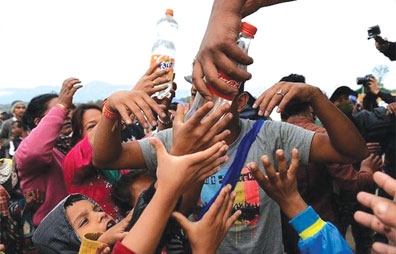
Individual reports highlight what supplies
or help are needed and where people are still without water and
food (BBC) |
In their 'situation room' in Kathmandu, Nama Budhathoki, and his team
of volunteers, process the hundreds of reports coming in from all over
Nepal asking for help.
"Urgent need of food and tent," says one before giving an exact
location. Others ask for water to be brought, saying "main issue is that
the water source is a half-hour walk away, across a landslide".
Requests
Yet more ask for medical supplies; bandages, pain killers and
diarrhoea medicine. "Every morning when I wake up I read those
requests... sometimes my heart just breaks," says 45-year-old Nama.
His non-profit Kathmandu Living Labs (KLL) is part of a global
crowd-sourcing effort to accurately map Nepal after the quake. They also
have an online platform for people to report where they are and what
they need.
KKL's first 'situation room' after the quake was this car park, with
aftershocks still rattling buildings
In 2010 Nama was doing a PhD in crowdsourcing, open data and social
and mobile media at the University of Illinois, Urbana-Champaign when
the Haiti earthquake struck.
That was when he realised that Nepal needed to be better mapped.
"Navigation in Kathmandu [was already] a nightmare; we don't have a
very good address system. If you get an invitation to dinner, to reach
that house you have to make six or seven calls to get directions.
"Nepal sits in one of the most risky zones for earthquakes and other
disasters. In Haiti they made [the map] after - I wanted to make the map
before the earthquake."
And so at the end of 2013, with a team of six volunteers, he started
mapping Nepal using open data software called OpenStreetMap.
How does open mapping work?
OpenStreetMap is a free, editable map of the world that anyone can
add to, sometimes described as the Wikipedia of maps. The community of
people online ranges from professional cartographers to anyone that
wants to help.
Aerial imagery provided by companies like Digital Global is used as
well as GPS devices and field maps.
Those mapping, who co-ordinate and help each other, break the imagery
into 'tiles' and literally trace roads, buildings and highways onto the
map.
The work of new mappers is validated by more experienced mappers to
ensure accuracy.
When the earthquake struck, Nama first made sure his family was safe,
but then quickly started recruiting volunteers. KLL had set up
operations to co-ordinate the mapping effort within 24 hours of the
quake.
He now has about 36 people in Kathmandu, along with more than 4,300
remote contributors from all over the world, helping relief agencies get
a clearer picture on the ground.
Neighbours
It's called 'crisis mapping' and similar technology and crowdsourcing
were used in Haiti and after Typhoon Haiyan in the Philippines in 2013.
Some in the mapping community who helped with those disasters are
sharing their skills and knowledge online for Nepal.
Groups as far away as the University of Sao Paulo and cities in the
US, as well as close neighbours in India, have held two or three day 'mapathons'
to help.
Ushahidi, another piece of technology inherited from Haiti and other
disasters, was used by KLL to build the platform for reports to come in
from anywhere in Nepal.
Individual reports highlight what supplies or help are needed and
where.
They are sent via an app, SMS or by calling - and then combined with
the plotted data on the map by Nama's team. They can then tell relief
agencies exactly what is needed and where.
Nama says in the immediate aftermath of the quake, relief workers
would head out to remote areas to help, but would have no information on
what was required.
"They took rice, for example. When they got there, they realised
that's not what the people there needed, they need tents.
"The problem was in the information. What do people need and what
relief can be offered?" he says.
The Red Cross was already working with KLL on mapping Nepal in
preparation for an event like this, says Dale Kunce, senior geospatial
engineer for the American Red Cross based in Washington DC.
He says they are using the maps after the quake to guide teams on the
ground about things like which routes might be prone to landslides,
where possible distribution centres could be based and where banks are.
"I wish there were a thousand KLLs all around the world for groups
like us, to provide local context and grounding," says Kunce.
"What KLL has done is empowered people to have an understanding of
the community around them and helped humanitarian actors to spend our
money more wisely and help more people."
Experience
He said, however, that he was not aware how widely their teams were
using the individual reporting platform provided by KLL.
Nama says the Nepal army checks the individual reports every two
hours and passes on relevant information to their relief operations
divisions.
"We had a report sent in by some people trapped in a remote area, and
in a couple of days they were rescued," he says.
"At the end of the day we know our reports help rescue operators to
save lives, or help people in some way. That is such a satisfying
experience."I've been able to bring a number of young people together,
energise them to do something collectively. "We need to grow the culture
of working together to fix the problems facing Nepal."
(Additional reporting by Pamela Koh
BBC Asia) |


")


