Bracing for a quake
by Januka Attanayake
Conventional wisdom tells us that Sri Lanka is not exposed to seismic
hazard because it is located well away from any active plate boundary in
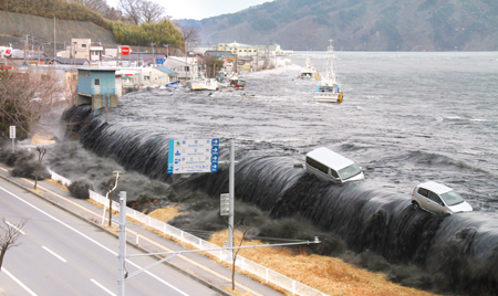
a stable continental region. The 2004 Indian Ocean Tsunami, however, has
left an indelible mark in the national psyche, and proved, possibly for
the first time in our 2500-year written history, that the island is not
totally immune to significant seismic hazards.
 |
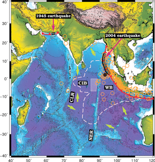
The Indo-Australian oceanic plate is diving under Burma and Sunda
minor plates, on which most of Southeast Asia is located, across a long
plane of contact (plate boundary) called the Sunda Megathrust at a speed
of about 6 cm/year in a North-Northeast direction. Although earthquakes
larger than about magnitude 8.4 were not expected, there is no doubt now
that slipping of large sections of the Sunda Megathrust can set off
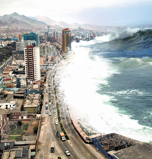
great earthquakes and tsunamis. For instance, the magnitude 9.3
Indonesian event ruptured roughly a 1500 km long segment in the Sunda
Megathrust, which is the longest rupture ever recorded (Figure 1).
Theoretical calculations show that reorganization of plates after this
particular event had affected even Earth's rotation, shortening the day
by about 2.5 microseconds - one hundred thousandth of time it takes to
blink an eye.
Interestingly, by dating sediment deposits in the Karagan Lagoon in
Hambantota, a group of international scientists led by Kelly Jackson at
the University of Miami recently found evidence of at least seven major
tsunamis with a repeat time of 500 -1000 years that had affected Sri
Lanka between 2400 and 7000 years before present. The origin of these
tsunamis, however, remains a mystery. That powerful earthquakes similar
to the 2004 event in the Indonesian region set off these tsunamis is a
reasonable assumption given the short record we have of seismicity.
Sediment dating done in Aceh (Indonesia) and Phuket (Thailand) provides
further evidence of two more recent tsunamis that have occurred roughly
600 and 1150 years ago though, geologic evidence corresponding to these
two events is still missing in Sri Lanka.
 |
| |
 |
| |
While we devote much of our attention to earthquakes that occur in
the Indonesian region, there is a record of great earthquakes associated
with the Makran subduction zone, triggering fatal tsunamis in the
Northwestern Indian Ocean (Figure 1). A magnitude 8.1 earthquake just
west of Karachi on 27 November 1945, ruptured the eastern section of
Makran subduction zone, setting off a fatal tsunami across the Indian
Ocean that claimed over 4000 people in India, Oman, and present-day
Pakistan and Balochistan. As a result of national and international
political instability during that time, documentation of this particular
event is sparse, but records indicate that the tsunami run-up far south
in Mumbai was as high as 6.5 feet.
This active fault zone is the geologic manifestation of the Arabian
plate crashing into the Eurasian plate, and runs in an east-west
direction for about 900 km. Seismic models predict the triggering of an
earthquake similar in size to the 2004 Indonesian event were the entire
fault zone to slip in a single earthquake. This worst-case scenario
might expose coastal communities in Sri Lanka to severe impacts.
With so many unknowns, however, one must keep in mind that this is
still a hypothetical event. Perhaps the most important lesson to be
learnt here is that, had the information about the 1945 tsunami been
passed down the generations, the number of fatalities in 2004 could have
been reduced significantly across South Asia. Thus, keeping the memory
of the 2004 Tsunami alive can save lives in the future.
Indian Ocean diffuse zone
There is also the talk of the Indian Ocean seismic diffuse zone - a
broad region of slow deformation separating the Australian plate to the
South from the Indian plate to the North - located several hundred
kilometers south of Sri Lanka, capable of producing damaging
earthquakes. Roughly about 15% of world's surface is covered with
diffuse zones, among which the Indian Ocean diffuse zone is the largest
and the most seismically active. This zone is at least 15 million years
old and exhibits accelerated deformation in the last seven million
years. It will probably take another several million years before the
diffuse zone transforms into a classic narrow plate boundary - if that
happens at all. The eastern section (Wharton Basin) of this diffuse zone
is separated from the western section (Central Indian Basin) by a
mechanical boundary called the Ninetyeast Ridge - a streak of strong
rock that runs from North to South roughly along the 90ºE longitude in
the Indian Ocean.
 |
| |
The Wharton Basin spans all the way from Indonesia to Australia and
is the most seismically active region in the diffuse zone with a clearly
demonstrated potential for producing very large earthquakes. In fact,
the magnitude 8.6 earthquake that occurred on 11April 2012 in this
region about 100 km west of the 2004 Indonesian earthquake is the
largest event ever recorded in a plate interior. The rupture style of
this earthquake, however, was not conducive for producing a tsunami.
It is now known that a majority of earthquakes in the Wharton Basin
has this same rupture style called strike-slip, where blocks of rock
move mostly horizontally, limiting the risk of tsunamis.
An interesting aspect of the 2012 earthquake is that it seems to have
released most of its energy along newly formed faults rather than older
more mature faults. Although geologic conditions in the Wharton Basin
are favourable for producing significant earthquakes, unusually large
events such as the 2012 earthquake are very rare. They appear to
originate in response to plate re-organization that takes place after
large earthquakes in the Sunda Megathrust.
The Central Indian Basin located directly south of Sri Lanka can also
produce earthquakes with a magnitude up to about 7, although its
potential to generate large earthquakes appear to be much less than that
of the Wharton Basin. This is because geologic conditions, for example
angle and the length of faults, in this region impose restrictions on
the size of earthquakes that can be generated.
Earthquakes in Sri Lanka
A recent study shows that deformation in the Central Indian Basin is
localized roughly between latitudes 0º-7ºS and longitudes 85ºE-90ºE.
Here, the lithosphere - the outermost rigid shell of the Earth where
most earthquakes occur -might be weaker than elsewhere due to
anomalously elevated temperature. This reduces the potential of
releasing pent-up strain energy in large earthquakes because a weakened
lithosphere facilitates deformation by either setting off smaller
earthquakes or folding, consistent with the observation of clustering of
smaller earthquakes in this area of localized deformation.
Nevertheless, if a hypothetical large earthquake (say, magnitude 7)
were to occur in this basin closer to Sri Lanka, subtle shaking can be
expected in the island, but it is not clear whether such an event can
trigger possibly a weak a tsunami.
At least the dominant style of faulting favours this hypothesis.
Perhaps a more important question is whether earthquakes can occur
within Sri Lanka itself.
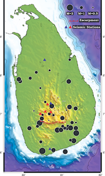
The answer might surprise very many, yes. To my knowledge, only one
proper scientific investigation has been published under peer review - a
critical check of science -on earthquakes in Sri Lanka. In the mid 80s,
M.J. Fernando and A.N.S. Kulasinghe analyzed data from a small array of
four temporary seismic stations, and located 47 microearthquakes
(magnitude less than 2.25) over 18 months (Figure 2).
They concluded that these microearthquakes might be resulting from
active slow uplifting taking place in the central highlands of Sri
Lanka.
The fact that they used a limited number of stations in the vicinity
of Kotmale dam does not allow for painting an islandwide picture of
seismicity. While this study suggests the presence of seismically active
geologic structures within the island, the exact location and their
hazard potential is not nearly as well determined.
Recently, I became aware of a pamphlet published by a shop-owner by
the name Jorge Rodrigues in Lisbon, Portugal describing an
"earthquake-like" event that devastated the communities in and around
Colombo in 1615.
A vague interpretation of it implies the occurrence of a magnitude of
6 earthquake near Colombo. It might take several months, if not years,
of searching to gather relevant original documents to conduct a
scientific investigation.
For now, I remain skeptical about this interpretation made by a
non-specialist. It must, however, be mentioned that large magnitude
earthquakes in stable continental regions such as Sri Lanka are not
unheard of. These are rare and have a recurrence interval on the order
of a thousand years. Conducting paleoseismological studies, identifying
potential seismic hazard zones and the continuous monitoring of
seismicity using an islandwide seismic network become all the more
important.
Last words
The greatest challenge in assessing the real seismic risk that we are
exposed to is our inability to reconcile the true distribution of deadly
earthquakes characterized by long recurrence intervals (500-1000 years)
with a short historical and an even shorter instrumental records (100
years).
Based on the studies conducted elsewhere, perhaps the most damage in
Sri Lanka can be expected from remotely-triggered events - local
earthquakes and landslides triggered by the passage of seismic waves
emanating from distant large earthquakes. On the other hand, if we are
able to confirm the occurrence of earthquakes with a magnitude 6 or
greater within the island itself, it will profoundly change how we view
seismic hazard as a nation.
For now, Sri Lanka remains quiet in terms of seismicity. This is
reflected in a seismic hazard map produced in 2007 by the United Nations
Office for the Coordination of Humanitarian Affairs, in which there is
only a 20% probability of an earthquake with a magnitude up to 5
occurring in a 50-year period. Nonetheless, the suggestion of the
presence of active structures warrants a careful closer look at
seismicity in the Island.
About the author:
The author is currently a Postdoctoral Scientist at WWU-Institut für
Geophysik in Münster, Germany and an Honorary Research Associate at
University College London. He is a member of the American Geophysical
Union and a life member of the Geological Society of Sri Lanka. |