|
Kiripokunahela:
The place that time forgot
Story and pictures by Mahil Wijesinghe
 Kiripokunahela, another magnificent archaeological site in the
Southeast, was the next port of call on the Kumana tour. Near
inaccessible because of the jungle overgrowth, Kiripokunahela lies on
flat-topped rocky boulder, nearly 260 feet above the Kumana jungle. The
site is located about three kilometres east of Babaragasthalawa and
eight kilometres from main park office at Okanda. Kiripokunahela, another magnificent archaeological site in the
Southeast, was the next port of call on the Kumana tour. Near
inaccessible because of the jungle overgrowth, Kiripokunahela lies on
flat-topped rocky boulder, nearly 260 feet above the Kumana jungle. The
site is located about three kilometres east of Babaragasthalawa and
eight kilometres from main park office at Okanda.
The jungle terrain and its location within the Kumana National Park
make it one of the least visited archaeological sites. Not surprisingly,
it is not included in any of the safari itineraries of the Park, and the
Park officials rarely give permission to visit the site, since there is
no motorable access way and it is too risky to walk the one and half
kilometres in the thick jungle.
Initially, we too were denied permission. However, our persuasive
ways and a written assurance that we were well aware of the risks we
were taking, got us the green light, along with two armed trackers to
accompany us.
Entry to the site is through a side path, off a well-trodden track.
The path is overgrown and potholed. Adding to the sense of adventure and
danger was the sight of a cluster of small tanks with their grass
damaged by wild elephants.
 A
one hour's bumpy ride into the thick jungle brought us to the edge of a
muddy plain. This was our destination - Kiripokunahela - literally a
massive rock boulder looming over us. There is no sign of any footpath
leading to the boulder, or over it to the archaeological site. But we
were curious to find out what was at the top. A
one hour's bumpy ride into the thick jungle brought us to the edge of a
muddy plain. This was our destination - Kiripokunahela - literally a
massive rock boulder looming over us. There is no sign of any footpath
leading to the boulder, or over it to the archaeological site. But we
were curious to find out what was at the top.
Thick jungle
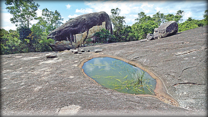
Following the two trackers, we cut through shrub bushes and stumbled
up a dark, nearly four metres long canoe shaped waterhole with greenish
water. This was Kiripokuna, which lies about one and half kilometres to
the north of Kiripokunahela. Wild animals, we were told, flock here
during the drought.
From Kiripokuna pool to the flat-topped rock boulder of
Kiripokunahela is a one kilometre walk. In the pathless thick jungle, it
takes more than half an hour to cover the distance. But the effort is
worth it.
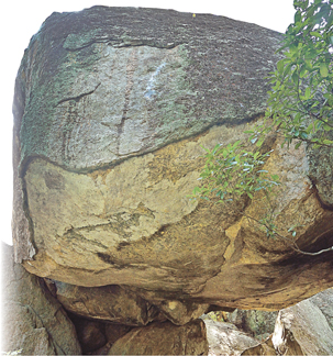
We climbed the boulder and stepped on the flat-topped surface, which
is nearly three hectares in size. On one side is a unique oval shaped
rock, the floor is smooth with small stones slabs. The face of the rock
massif has grooves etched around it, preventing rain water from flowing
into the cave. On top of the rock surface, just below the massif, are
several lines of Brahmi inscriptions. And in front of the rock is a
small waterhole. Beneath the rock we could see the remnants of an
ancient brick wall.
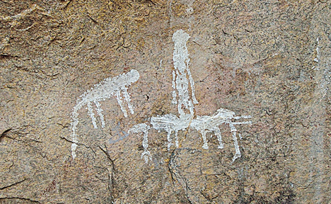
 The
most striking feature of the main drip-ledged cave of Kiripokunahela is
the primitive drawings, one of which in stark white depicts a leopard
leaping on a man astride an elephant. The early inhabitants are believed
to have used a thick white paste, probably lime on to draw the figures.
There were hints of under another faded painting of animals and people
under the main drawing. There are no indications as to who did these
drawings or to which period they belonged to, but given the fact that it
is in Kiripokunahela, it gives a sense of the early inhabitants in the
country. The
most striking feature of the main drip-ledged cave of Kiripokunahela is
the primitive drawings, one of which in stark white depicts a leopard
leaping on a man astride an elephant. The early inhabitants are believed
to have used a thick white paste, probably lime on to draw the figures.
There were hints of under another faded painting of animals and people
under the main drawing. There are no indications as to who did these
drawings or to which period they belonged to, but given the fact that it
is in Kiripokunahela, it gives a sense of the early inhabitants in the
country.
Crumbling Dagoba
As we walked around the rock surface, one of the tracker showed
another huge rock boulder, which had been linked with Kiripokunahela. It
lies just 200 metres east of Kiripokunahela and boasts of a cluster of
fascinating drip-ledged caves and a rock cut flight of steps that lead
to the remains of a crumbling Dagoba.
Strangely, we noticed the flight of steps start from the middle of
the rock and not from the bottom, which meant, we had to hold on to the
trees and literally crawl to the step, to reach the summit and get a
glimpse of the Dagoba, built with bricks and stone slabs.
It is interesting that no one seems to know much about the origin of
this enchanting archaeological site. But considering the rest of the
archaeological finds spread across Kumana, we could only assume that
this too had also been a prominent Buddhist monastic complex in the 2nd
and 3rd Century BC.
|
Kiripokunahela drip-ledged rock cave with its primitive
artwork on the rock surface. |
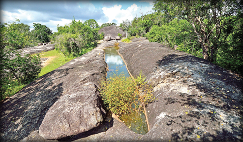
The Kiripokuna waterhole, a perennial source of water, one
kilometre north of Kiripokunahela. |
|