|
Why Aranayake ?
An expert explains as to why a single village became the epicenter of a massive
natural disaster :
By R.M. S. Bandara
The effects of climate change and climate variability give rise to frequent
disasters globally, and the frequency of occurrence which has been observed as
ever increasing. The situation in Sri Lanka is no exception, with landslides and
flood incidents, becoming too frequent. Heavy and localized rains which fell in
Sri Lanka during recent times caused an unprecedented disaster situation.
Landslide means any type of movement of ground mass including land subsidence
created due to natural causes or human activities. In the global context,
landslides are triggered by earthquakes, volcanos, snow-melting and heavy
rainfall. Almost always in Sri Lanka, landslides are triggered by rainfall. At
times of heavy rainfall, water infiltrates through the top soil on the ground
into the deep soil layers beneath, thus filling in empty pores in the soil. When
the water in pores reaches close to saturation, it exerts a pressure internally,
called ‘pore water pressure’ and it causes the soil to behave differently.
 There are many factors that affect the stability of a slope. Important among
them area: slope angle, the geology of the area, overburden thickness,
hydrology, land use patterns and the landform. National Building Research
Organisation (NBRO) since 1985 has been investigating landslides in the country. There are many factors that affect the stability of a slope. Important among
them area: slope angle, the geology of the area, overburden thickness,
hydrology, land use patterns and the landform. National Building Research
Organisation (NBRO) since 1985 has been investigating landslides in the country.
By gathering information in fieldwork and analyzing the effects of the above
causative factors and then assessing the associated landslide risk, NBRO
prepares Landslide Hazard Zonation Maps covering all the areas prone to
landslide hazard in 10 districts in the country. At present, the NBRO carries
out the tasks of monitoring landslide hazard and forecasting landslide movement
with the support of a network of automated rain gauges and ground movement
sensors, early warning for evacuation, awareness building through workshops,
mainstreaming knowledge into national and local development planning processes,
engineered mitigation of dangerous landslides and unstable slopes, and most
importantly, the issuance of Landslide Risk Assessment Reports incorporating
technical advice as a pre-requisite for giving building permits and project
approval by local government bodies.
Landslides
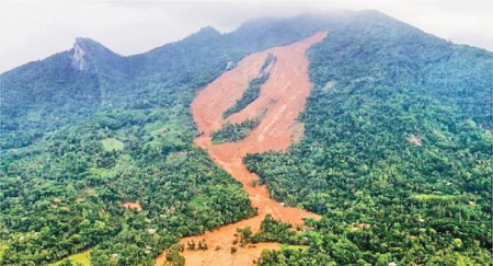
The tragic landslide at Aranayake resulted in a catastrophic situation, burying
parts of three villages, namely Siripura, Elangapitiya and Pallebage. It is
believed that a large number of people lost their lives. The remains of 19
victims have been recovered, but search operations have been hampered by the
inclement weather and the fact that the site conditions are considered too
dangerous for such wet weather.
This region had experienced a cumulative rainfall of about 435 mm, as verified
based on the data from automated rain gauges of the NBRO, for 4 consecutive days
from 14 to 17 May. With this torrential rainfall which continued for several
days, a portion of the Siripura – Elangupitiya hill at Dippitiya, Aranayake had
been subjected to a sudden landslide situation on 17 May around 4.30-5.00 p.m.,
completely burying a good number of houses and properties in the slope region
and resulting in heavy casualties.
The exceptionally high rainfall that triggered the landslide is due to the
low-pressure formation in the atmosphere around Sri Lanka, associated with a
slow moving tropical cyclone in the Indian Ocean. The Meteorological map shows
the rainfall distribution during 14 and 15 May. An expert team from NBRO
conducted a geological investigation in the area where the landslide occurred.
It has taken place on an escarp slope inclined towards the north-east direction.
When its geomorphological formation is considered, the affected area is a steep
slope.
The slides occurred on the upper and middle incline of the slope respectively,
where the slope is nearly vertical in two places. The area in between is covered
by a thick colluvium left by past landslides that have been occurring over a
long period of time, and this layer consists of boulders of varying size
embedded in past landslide debris. In the intermediate area of the slope and
just below the escarpment, there are two major valleys oriented towards north
and north-west. There are thick colluvium soil layers on either side of these
two valleys and also on the upper area of the scarp in between the two valleys.
With heavily jointed rocks underneath, this area has had a high potential for
landslide. There had been many houses located in the affected slope and below.
The entire area had been cultivated with minor export crops (cloves, coffee,
pepper etc.) and fruits. Some of the access roads had been paved with concrete
or asphalt.
As shown in the map, according to the 1:10,000 scale landslide risk zonation map
compiled by the NBRO for the Aranayaka Divisional Secretariat, the region where
the landslide initiated falls to the high hazard zone, and the crown area of
this landslide had already been marked in red by the NBRO.
The width of the crown of the landslide is about 345 -350 m and the scrap height
is about 50-75 m. The widest part of the landslide is approximately 600 m.
Completely unaffected home gardens and a natural forest cover could be observed
in the intermediate area of the slide, while several houses still remain
undamaged. Down the right-side of the landslide, a quite rapid and muddy water
flow could be observed. The region covered with debris at the toe of the
landslide could be split into two regions: the left side is about 75-125 m wide
while the right-side is about 350-450 m wide.
A debris flow about 75-100m wide and 2.3 km long, was observed close to the toe
of the landslide in the valley oriented towards north-east. A debris flow is a
downward flow of accumulation of rock fragments, soil, water and other debris,
which flows down very rapidly like a slurry destroying houses and trees on its
path and carrying together all the debris including driftwood, damaged houses
and structures, causing a very dangerous condition. The toe of the debris flow
is lying on a plain with paddy fields. The bedrock of the area is a high grade
metamorphic rock called Garnet Biotite Gneiss in which two major vertical joints
could be observed.
Vegetation
Deep-rooted vegetation is important for assuring the stability of soil slopes.
Vegetation like forest cover allows water to infiltrate the soil slowly, and
deep root systems protect the slope by developing a mechanical effect which
reinforce loose overburdens by anchoring into the hard stratum. Root system of
tea plants, on the other hand, are not capable of providing such protection. It
was observed that the area where this landslide has been triggered is mostly
covered by tea plantation, which may have been a contributing factor to the
landslide.
By scientifically assessing this landslide, it could be concluded that several
major factors contributed to it. The two escarpments in the slope are made of
mainly jointed metamorphic rock with possible thin soil cover. Due to improper
land use methods employed in the tea cultivation on the upper regions of the
escarp slope, the rainwater had quickly infiltrated into the soil slope. Hence,
high pore water pressures would have built up at the boundary of thin soil layer
and rock underneath,with the heavy prolonged rainfall. The excess water
penetrated into the system of joints in the rock would have generated a high
destabilizing force. The excess pore pressures in the thin soil layer would have
caused a major reduction in its shear strength and made it to slide. The
excessive pore pressures developed in the rock joints has caused the rock blocks
to slide or topple along the joint planes. Finally, all these have accumulated
into a debris flow.
The debris flow that started at the steep escarpment at the upper level has
moved down to the flat terrain at the intermediate level where a number of
houses were located.The thick layer of colluvium in this terrain too, had got
saturated due to the prolonged rainfall, and the debris flow originated from the
top steep escarpment had moved there, destabilizing it further with the impact.
Initially, the colluvium layer would have started to slide, but it had turned
into a debris flow quickly, completely destroying the houses in the terrain. The
debris flow had then moved down the second steep escarpment destroying the
houses in the lower level. The speed of the debris flow would have increased
several times more when it moved downwards along the escarp slope of about 700
angle found at the intermediate region of the slope, owing to the
geomorphologyof the area.
All things considered, it could be recommended that this entire region subjected
to the landslide should be declared as a restricted zone and no human activity
should be tolerated there for any reason.The entire slope region on either side
of the landslide area is not suitable for settlement and should only be used for
agricultural purposes. However, it is a must to implement proper land use
patterns and a systematic surface drainage system in the area.It is essential to
immediately implement a nationwide program to necessitate the planning of
existing land use patterns and construction techniques considering the natural
slope and geology in the mountainous regions of the country.
Here, any construction activities, cultivations, change in land use pattern
leading to slope instability should not be done without proper approval taken
from the NBRO. Local government authorities have been instructed not to grant
approval for such activities without the approval of NBRO by the circular number
2011/1/NBRO issued by the Ministry of Disaster Management.
The writer is the Director,
Landslides at NBRO. |