
Floating on the Dead Sea
Imagine reading your favourite book, while floating on the sea, on a
nice sunny day. Yes, you read it correct, reading while floating on the
sea. If you have already heard of the Dead Sea, you will not be so
amazed to hear such a thing. But for those who are unaware of this, the
Dead Sea makes anyone float easily in it due to its high concentration
of salt. While considered as one of the major centres for health
research and treatments, the Dead Sea has many mysterious stories behind
it.
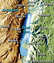
The Dead Sea is the lowest exposed point on the Earth's surface. It
is on the border between the West Bank, Israel, and Jordan on the Jordan
Rift Valley. It is the deepest hypersaline (salty) lake in the world.
The Dead Sea is 67 km long, up to 18 km wide and 799 m below sea
level in depth at its deepest point. The surface elevation of the Dead
Sea and therefore its immediate shoreline is the lowest land point on
the face of the Earth. According to the Wikipedia Encyclopaedia, as of
2006, its surface is at an elevation of 418 m (1371 ft) below sea level,
although this is reducing over time.
The Dead Sea has attracted interest and visitors from around the
Mediterranean basin for thousands of years. It was a place of refuge for
King David, it was one of the world's first health resorts for Herod the
Great, and it has been the supplier of products as diverse as balms for
Egyptian mummification, to potash for fertilisers.
In Hebrew, the Dead Sea is called the Yam ha-Melah, meaning "sea of
salt", or Yam ha-Mavet meaning "sea of death". In the past, it was the
"Eastern Sea" or the "Sea of Arava". In Arabic, the Dead Sea is called
Al Bahr al Mayyit meaning "the Dead Sea", or less commonly Bahr Lut
meaning "the Sea of Lot". Historically, another Arabic name meant the
"Sea of Zoar", after a nearby town. To the Greeks, the Dead Sea was
"Lake Asphaltites".

The Dead Sea actually has water flowing into it. The Jordan River
runs into the Dead Sea. The Dead Sea is located in the Dead Sea Rift,
that is part of a long fissure (cleft) in the Earth's surface called the
Great Rift Valley.
The 6000 km (3700 miles) long Great Rift Valley extends from the
Taurus Mountains of Turkey to the Zambezi Valley in southern Africa. The
Great Rift Valley formed in the Miocene times as a result of the Arabian
Plate moving northward and then eastward, away from the African Plate.
Around three million years ago, what is now the Valley of the Jordan
River, Dead Sea, and Wadi Arabah or Nahal Arava was repeatedly inundated
(flooded) by waters from the Mediterranean Sea. The waters formed in a
narrow, crooked bay, which was connected to the sea through what is now
the Jezreel Valley.
The floods of the valley came and went, depending on long scale
climatic changes. The lake that occupied the Dead Sea Rift, named "Lake
Sodom", deposited beds of salt, eventually coming to be 3 km (2 miles)
thick.
According to geological theory, two million years ago, the land
between the Rift Valley and the Mediterranean Sea rose to such an extent
that the ocean could no longer flood the area. Thus, the long bay became
a long lake.
The first such prehistoric lake is named "Lake Gomorrah". Lake
Gomorrah was a freshwater or brackish lake that extended at least 80 km
(50 miles) south of the current southern end of the Dead Sea and 100 km
(60 miles) north, well above the present Hula Depression. As the climate
turned more arid (harsh), the lake shrank and became saltier.
In prehistoric times, great amounts of sediment collected on the
floor of Lake Gomorrah. The sediment was heavier than the salt deposits
and squeezed the salt deposits upwards into what are now the Lisan
Peninsula and Mount Sedom.
Geologists explain this effect in terms of a bucket of mud into which
a large flat stone has been placed, forcing the mud to creep up the
sides of the pail. When the floor of the Dead Sea dropped further due to
tectonic forces' the salt mounts of Lisan and Mount Sedom stayed in
place as high cliffs.
Between 70,000 and 12,000 years ago, the lake level was a 100-250
metres higher than its current level. This lake, named "Lake Lisan",
fluctuated (changed) dramatically, with it rising to its highest level
around 26,000 years ago, indicating a very wet climate in the Near East.
Around 10,000 years ago, the lake level dropped dramatically,
probably to levels even lower than today. During the later several
thousands of years, the lake fluctuated around 400 m with a few
significant drops and rises.
The northern part of the Dead Sea receives scarcely 100 mm (4 inches)
of rain a year; the southern section barely 50 mm (2 inches). The Dead
Sea zone's aridity is due to the rainshadow effect of the Judean Hills.
The highlands east of the Dead Sea receive more rainfall than the Dead
Sea itself. Beginning in the 1960s, water inflow to the Dead Sea from
the Jordan River was reduced as a result of large-scale irrigation and
generally low rainfall. By 1975, the upper water layer of the Dead Sea
was actually saltier than the lower layer.
The upper layer nevertheless remained suspended above the lower layer
because its waters were warmer and thus less dense. When the upper layer
finally cooled down so that its density was greater than the lower
layer, the waters of the Dead Sea, after many centuries, finally mixed
and the lake was a homogeneous (of the same kind) body of water. Since
then, the stratification (forming into layers) has begun to redevelop.
We will tell you more about the mineral composition of the Dead Sea
in a future issue. |