
by Pramod de Silva
We often take the wheel without having a very clear idea of how we
are going to get to our final destination. It’s a familiar story - stop
at various places and ask for directions. Sometimes, we take a far
longer or even an altogether wrong road, wasting time and of course,
money (fuel).
Ever wished you had a completely dependable, knowledgeable guide to
literally show you the way? Fear not, it is already here. It is called
Satellite Navigation. Now you don’t have to rely on guesswork, outdated
printed maps and bystanders to arrive in your destination.
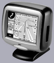
 The idea behind Satellite Navigation is simple. You just punch in
your destination and an in-car unit will guide you through voice
commands and on-screen maps, turn by turn. They take advantage of the
Global Positioning System (GPS) satellites to give you real-time
information on traffic conditions as well, so you can avoid congested
roads. The idea behind Satellite Navigation is simple. You just punch in
your destination and an in-car unit will guide you through voice
commands and on-screen maps, turn by turn. They take advantage of the
Global Positioning System (GPS) satellites to give you real-time
information on traffic conditions as well, so you can avoid congested
roads.
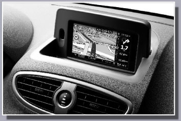
It is in its infancy in this country, but a few years down the road
the systems and usage charges will become considerably cheaper.
Most carmakers now fit them as standard equipment anyway, at least on
the higher-priced models. Or you can always opt for an aftermarket unit.
What’s more, most SatNav systems indicate where fuel stations,
restaurants, hotels, shopping centres are, so that you can stop and
refresh.
 Most screens feature 3-D maps with lots of details. Some of the
latest aftermarket SatNav units sport a built-in TV and DVD, so you can
keep the passengers entertained. Another advantage is that some units
are detachable - they can be taken when you go even for a walk to find
your way. Most screens feature 3-D maps with lots of details. Some of the
latest aftermarket SatNav units sport a built-in TV and DVD, so you can
keep the passengers entertained. Another advantage is that some units
are detachable - they can be taken when you go even for a walk to find
your way.
There is another advantage - GPS units can track your exact location.
With the addition of some extra hardware and software, the authorities
can track it down if stolen.
The same applies in a breakdown/accident scenario as emergency
services can rush to the location. Like most emerging technologies,
SatNav does have some limitations. For example, satellite signals cannot
permeate tunnels and underground structures.
The SatNav does not work in such areas. It is also as good as the
mapping data allows - street-level information changes day by day and
may not have been updated by your system. |


