|
To minimise flood damage:
Need for spatial planning in development
by U.A. Chandrasena
 Today’s society is ever more vulnerable to natural disasters due to
the concentration of population, environmental degradation and a lack of
planning, management and preparedness. With an alarming increase in
natural disasters throughout the world, caused by global climate change
as well as due to adverse effects of human intervention, the time has
come to take immediate steps to minimise the loss of human lives, damage
to economy and environment. Today’s society is ever more vulnerable to natural disasters due to
the concentration of population, environmental degradation and a lack of
planning, management and preparedness. With an alarming increase in
natural disasters throughout the world, caused by global climate change
as well as due to adverse effects of human intervention, the time has
come to take immediate steps to minimise the loss of human lives, damage
to economy and environment.
About 90 per cent of the natural disasters that occurred recently are
of hydro-meteorological origin (involving water) and most of the victims
throughout the world were affected by flash floods, cyclones, droughts,
heat waves, bushfires and tsunamis.
Resulting from atmospheric behaviour and subjective terrain features,
any high intensity of rainfall can cause excessive flow of water,
inundating the adjacent areas of river banks in a drainage basin,
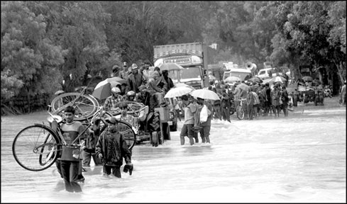
commonly known by local people as Ganwathura or floods. A flood plain at
any scale consists of its flood ways, flood storage and flood fringe
which we must consider as one system.
Flood ways allow the flow of run-off water while flood storage
retains water for the short term. Development activities, particularly
deforestation and intensive crop production, may have drastically
changed run-off conditions, thereby increasing stream flow and the risk
of flooding.
More intensive use of the floodplains, and clearing for agriculture
led to a progressively higher percentage of flood discharge.
 In Sri Lanka, all major rivers start from the central hills. The
mountainous regions receive an intensive rainfall due to storms, or at
the peak of the monsoon season, areas of the lower course of rivers, get
flooded. Floods which contribute to about 50 per cent of total disaster
occurrence in the country is the commonest of natural disasters causing
damage to life and property. The districts most prone to floods during
that period were Kalutara, Ratnapura, Colombo, Gampaha, Puttalam, Matara,
Galle, Ampara, Polonnaruwa and Hambantota. In Sri Lanka, all major rivers start from the central hills. The
mountainous regions receive an intensive rainfall due to storms, or at
the peak of the monsoon season, areas of the lower course of rivers, get
flooded. Floods which contribute to about 50 per cent of total disaster
occurrence in the country is the commonest of natural disasters causing
damage to life and property. The districts most prone to floods during
that period were Kalutara, Ratnapura, Colombo, Gampaha, Puttalam, Matara,
Galle, Ampara, Polonnaruwa and Hambantota.
Since May 14 heavy pre-monsoon rains along with lightning and thunder
have resulted in flash floods, high levels of water, strong wind and
landslides in 14 of the 25 districts in Sri Lanka; Colombo, Gampaha,
Kalutara, Ratnapura, Kegalle, and Galle are the most affected.
The Gampaha district was the hardest hit by this flood with 39,557
families (164,352 people) being affected in 362 GN areas of 12
Divisional Secretariat Areas, by May 20. Loss of life was the highest
among the districts. Wattala Division reported the highest number of
victims while Ja-ela, Katana, Kelaniya and Gampaha divisions were also
severely affected. Three major causes of the flood hazard, as the public
perceived, were unauthorised and authorised filling of low lying areas,
expanding built-up areas without proper measures for regulating surface
run-off and lack of maintenance of irrigation drainage networks.
Key instrument
Spatial planning is a key instrument for establishing long-term,
sustainable frameworks for social, territorial and economic development
in an area.
Its primary role is to enhance the integration between sectors such
as housing, transport, energy and industry, and to improve national and
local systems of urban and rural development, also taking into account
environmental considerations.
Spatial planning can contribute to the prevention of the risks and
mitigating the effects of natural and environmental disasters and
maintaining the equilibrium between protected areas and development.
With regard to natural hazard management, spatial planning has
instruments at hand to keep free those areas of future development that
are (1) prone to hazards (e.g. flood-prone areas, avalanche-prone
areas), (2) that will be needed to lower the effects of a hazardous
event (e.g. retention areas) and (3) that will be needed to guarantee
the effectiveness of response activities.
One advantage of spatial planning is facilitating the integration of
risk management plans and social participation for development. Risk
assessment and hazard mapping would then be used to delineate areas
vulnerable to natural hazards and determine the frequency and intensity
of impact.
The application of expertise in physical planning and land use
planning at various levels of spatial planning is indispensable in this
regard. Land use planning such as floodplain zoning is a process of
determining the most desirable way land should be used so that it can
help to mitigate disasters and reduce risks by directing development
away from hazard-prone areas.
The land systems mapping, which has been applied in many developing
country situations and for rapid surveys for land use planning, would be
an appropriate and participatory tool for that purpose. The term ‘land
system’ was first coined by Christian and Stewart (1953) in their study
of the Katherine-Darwin region of Northern Australia.
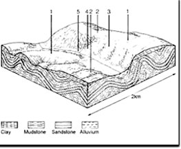
A land system is an area with a recurring pattern of topography,
soils and vegetation and with relatively uniform characters. An area is
subdivided into land facets which are the smallest areas that can be
recognised and delineated on aerial photographs and are usually linked
by geomorphologic processes.
The watershed provides the best demarcation criteria for land systems
mapping in the humid tropical countries rather than terrain
characteristics alone.
A watershed is a topographically defined area of land where the water
within flows to a common point. Watershed Based Zoning is the foundation
of a land use planning process using sub-watershed boundaries as the
basis for future land use decisions.
The development of watershed analysis and its application to land
management issues have provided a valuable tool for conducting
scientific analyses of potential environmental impacts and enabling
government agencies, industry, and local landowners and citizens to make
informed decisions about how their lands will be managed.
Planning for Gampaha district
Gampaha is one of the pivotal areas of Sri Lanka’s development path
towards a miracle economy in Asia. It is worthwhile to think of the
rationale for spatial planning along with economic planning to keep
development going on in harmony with the environment.
The district has five drainage basins and they cover almost all the
catchment areas, valleys and plains in the district. The agricultural
land use, mainly paddy and coconut and homesteads are located as
integrated land use systems compatible with the landscape of these
basins.
Spatial patterns of population, settlements, land use and other
economic activities depict a highly imbalanced growth, taking place in a
haphazard manner. Most of the tertiary sector activities as well as
industries are concentrated in the western coastal strip of the district
while most of the recently developed residential areas are located in
their peripheries.
The drainage pattern of the southern and western parts of the
district consists of drainage basins of Muturajawela and Negombo lagoon
systems and the Northern bank of the Kelani River valley.
Attanagalu Oya extends over about one-third of the land area and
comprise several sub-units (facets) of a land system. Dandugam Oya
provides another catchment area in the lower part of the plain. In the
northern border the drainage system is connected to the Maha Oya while
some water courses are opened to the Kelani River in the South.
Land use zoning plans based on these drainage basins could guide the
development of the respective areas if properly designed, considering
terrain characteristics as well as other properties of the land systems.
Any haphazard development can be prevented and the natural environment
be protected, extending minimum adverse effects thereby.
A spatial framework of the regional physical plan composed of land,
people, and resource endowments is essential for promoting and
regulating development. The demarcation of regions in the district based
on topography and drainage provides a better understanding of
sub-regions to be considered separately with special development and
conservation requirements.
The Mahinda Chinthana Idiri Dekma provides for achieving development
while preserving nature’s Nillapirunu Ratak so that any development
should be in harmony with the environment. The selection of sites,
location of services and development of infrastructure may be the prime
task of planners and policy-makers to achieve the expected development
goals.
Development of a spatial information base and designing appropriate
development plans based on catchments of the drainage systems and
diversity of socio-economic characters in the district is a timely
requirement for these reasons. Geographic Information Systems (GIS) play
an important role in disaster risk assessment and management.
The abilities of GIS to synthesise a wide variety of data and analyse
complex spatial relationships have, therefore, made it an essential
planning tool. Using the latest automated floodplain mapping software,
DEM, DTM, and TIN data can be used for computing floodplain elevations
and mapping floodplain boundaries.
The Gampaha district is far ahead of other districts in the Western
Province in terms of road development due to the various projects
implemented in the district under the Maga Neguma. Future development of
the area depends greatly on availability of land, environmental quality
and disaster vulnerability.
Key areas of attraction and more promising ventures such as tourist
industry, export oriented production and knowledge intensive industries
would be feasible in the district due to its comparative advantages.
Therefore, a comprehensive spatial planning effort would be
indispensable for guiding sustainable and promising development in the
district, providing an example to the rest of the country.
The writer is senior Lecturer, Department of Geography, University of
Kelaniya. |


")

