|
Learning from disasters:
Adverse effects of reckless construction
|

R.M. Senerath Bandara
|
The rainy weather continuing for over a month has adversely affected
people in the country. There was no sun light for more than three weeks
in some areas thus leaving over 160,000 people in several districts
including in the North homeless due to floods, flashfloods and
landslides.
|
Info on
dams
With
this disaster situation we are collecting information on
dams that are filled and villages which have been flooded.
We have to educate people to leave the area when there is a
danger.It is predicted that the rains will continue for
another few days. Because with this climate change
prediction is very difficult. Even the Meterological
Department is facing difficulties in predicting the weather
conditions. So we have to keep an eye on this situation. Not
only in Sri Lanka this is also happening in India. Therefore
this is situation affecting regionally. n Learning from
disastersInfo |
Many reservoirs have reached full capacity making picturesque views
of spill gates after more than 15 years. The hydropower stations are
running at their full capacity injecting maximum energy to the national
grid.
The continuation of this weather would result in environmental
catastrophe in many parts of the country. Certain areas will be prone to
disasters such as landslides and floods. However unexpected weather
condition that affected the country has given chances for the
decision-makers and also the common masses to think twice about the
disastrous situation that may occur in the future.
According to W.U.L. Chandradasa, Director Disaster Mitigation and
Training of the Disaster Management Centre, the country is experiencing
an unusual weather condition. “This situation is experienced at regional
level as our neighbouring India is experiencing a similar situation”, he
said.
“For the last 20 days the country experienced continuous rain in
various parts of the country displacing over 160,000 last week”, he
added.
The Mannar district is the worst affected with more than 40,000
people affected by floods. The number of people affected by the floods
in the Kilinochchi district was over 30,000 on Thursday evening.
 Many earthslips were reported from the Kandy, Kegalle and Ratnapura
districts. In Colombo six earthslips incidents were reported. Many earthslips were reported from the Kandy, Kegalle and Ratnapura
districts. In Colombo six earthslips incidents were reported.
“With the increased rainfall more landslides are expected”,
Chandradasa added.
As explained by him many landslides have been reported due to slope
failures.
“People have cut steep slopes to construct houses and with the
saturation of soil there are structural failures of houses. That is how
most of the houses got damaged. Those failures are getting increased
because soil saturation decreases the bearing capacity resulting
structural failure in houses”, he said.
This is happening in the Kandy area and it could happen in other
areas with soil erosion taking place where steep have been cut down for
construction of houses.
“This will be a serious situation that will occur in the future.
Therefore, some action has to be taken to make people aware of the
danger of constructing houses in steep slopes and educating them on the
methods of constructing houses in such places without creating problems
in the future”, Chandradasa added.
 The Disaster Management Centre along with the Disaster Management
Ministry is taking steps to educate the Local Authorities not to approve
plans and encourage people to cut steep slopes for construction purposes
without taking precautionary measures to avoid landslides. The Disaster Management Centre along with the Disaster Management
Ministry is taking steps to educate the Local Authorities not to approve
plans and encourage people to cut steep slopes for construction purposes
without taking precautionary measures to avoid landslides.
“The danger is not only for those who cut steep slope, the people
living top of them also get affected due to this situation”, he added.
The low-lying areas get affected due to the prevailing weather
conditions.
“With the increase of rain and the saturation of soil the capacity of
the drains are not enough to drain the waters, Chandradasa added. But
with the recent work that has been done after the flash floods that was
reported mid of this year most of the canals were cleaned.
“Canals in Colombo at the moment are working well. But with the high
rainfall these canals also cannot cope up with the water level”, he
added.
“The flow of water is smooth, but there are problems regarding the
filling of lands. Unless we pay attention to these areas these lands
cannot absorb the waters flowing to these areas”, he added.
But the flood reported in the districts of Mannar, Kilinochchi and
Mullaitivu were due to other factors.
“Development has started there now. No maintenance has been done in
the tank systems there for several years. We have found 14 tank bunds
that have been breached creating problems in downstream areas in those
districts”, Chandradasa added.
The Disaster Management Ministry has taken steps to provide dry
rations and cooked meals for those displaced and for those in 59 IDP
camps.“The Ministry has allocated funds to the GAs. Whatever the funds
they have asked has been released. There is no shortage of funding for
food”, he added. The Disaster Management Centre also mediated to get the
assistance of the Army and the Navy to blast the sluice gates of Nalanda
Dam in Matale which were not functioning properly after the water level
rose 75 feet above the spill gates causing alarming situation there.
“There is a danger it could collapse any moment. Therefore, they
requested us to immediately to help us to breaking some parts of the
bund. So we spoke to the Navy and to the Army on Wednesday and they
broke a part of the dam so that water can flow”, Chandradasa added.
Nalanda Tank Matale, was the first tank to have concreted a dam 50 to
60 years ago.
Likewise the Disaster Management Centre was in constantly touch with
the people to rescue them from disasters.
The Disaster Management Centre collected more data on areas which
were flooded due to the overflow of reservoirs and the rivers especially
four reservoirs connecting to Kirindi Oya which had overflowed after 15
years.For 15-years there had been no water in downstream areas of these
reservoirs and the people had to be vigilant.
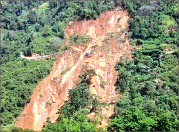
The Beragala landslide |

The Victoria Dam |
“It was happening in all the areas as all the tanks are full to their
capacity. In one way it is good but on the other there is a danger on
that because we have to keep an eye on it”, he added. With regard to
landslides we are on vigilant and the National Building Research
Organisation also vigilant. They are warning people on impending
dangers.
R.M. Senerath Bandara the Head of the Landslides Studies and Service
Division of the National Building Research Organisation said continuous
rains had an impact on several areas in the country.
Hambantota, Matara, Galle, Kalutara, Colombo, Ratnapura, Kandy,
Matale, Kegalle districts have been affected due to the rainy weather.
“Earthslips, rock falling and cutting failures were reported from many
parts of the country and a large number of incidents have so far been
reported from the Kandy district. Incidents were reported from Kegalle,
Kalutara and Ratnapura districts”, he added.
According to Bandara the districts of Matale, Mahanuwara, Kegalle,
Ratnapura, Kalutara, Matara, Hambantota, Galle, Badulla and Nuwara Eliya
have been identified as landslide prone districts. “We have identified
these districts in the hill slopes as landslide prone areas. But we also
received six incidents from the Colombo district”, he added.
“Many earthslips reported during this period were not due to natural
causes. Many incidents have been reported due to human acts. The
incidents of cutting failures and collapses were due to improper use of
lands by the people. More than 80 per cent of such incidents are
reported due to human acts”, he explained.
The NBRO is conducting investigations on the incident in which a huge
house in Aniwatta area in Kandy district was affected.
“In our preliminary investigations it has been found that undue
weight has been put into the hill slope due to the construction”, he
added.
The house has not been fixed to the earth according to the accepted
engineering methodologies. Due to the undue weight the house used to get
slipped as it has been constructed in pillars. When one pillar collapses
others get affected as they get the full weight on them, he added.
Apart from that on the Kandy- Matale road at the 19th mile post over
40 meters have been washed into the river.
Several landslides have also been reported from Gangawatakorale,
Ukuwela and Ampitiya areas in the Kandy district.
“We have found a tendency of cutting failures in many areas. That is
because people are careless when they are constructing houses in hill
slopes. We have to inform the people to be more careful when they are
constructing houses in the hill slope and to strictly follow proper
engineering methodologies and proper drainage systems when they
construct houses in hill slopes”, he added.
People have to be careful to have retain structure if they cut the
land for construction and also to have properly maintained drainage
system if they are living on in a hill slope.
The NBRO is constantly in touch with the people in Hantana and
Bahirawakanda in Kandy district and we are instructing people to follow
proper engineering methods when constructing building in these hills.
“Now we realise that there are certain shortcoming in those
structures as earthslips place regularly in these areas”, he added.
The Kandy district is not a major hilly area. The major hilly areas
are in Ratnapura, Badulla, Nuwara Eliya and Walapone area. Despite many
areas received higher rainfall during this period rainfall received by
these areas are comparatively low. But these areas are also now
receiving considerably higher rainfall. “If rains continue for another
few weeks we will have to face natural landslips in those areas.
Even at present the soil has absorbed maximum water level due to the
high intensity rainfall”, Bandara added.
“We have experienced many landslides in 2003 and 2007 following high
intensity rainfall within 24 hours resulting huge land slides.
According to Bandara the role of the National Building Research
Organisation is to investigate the areas which are prone for land
slides. After a landslides the NBRO have to find out whether the area is
prone for further landslides or whether the area is safe for people to
live or they should be shifted to safer places.
“If we can conduct a proper investigation to ascertain as to why that
landslide has happened we can take precautionary action. Many landslides
occur due to the mismanagement of the flow of water into the area and
cutting of the steep slopes and due to the removal of supporting stuff
on the slope. We can make use of the land by improving the drainage
system and creating retain walls.
To avoid future disasters in landslide prone areas the NBRO is now
mapping out landslide prone areas and it had completed mapping in seven
districts and provided those 1:50,000 maps for decision makers to make
use of these data in their future development plans.
“We are educating government officials and draughtsmen and land users
about the maps so that they can make use of these lands properly for
development purposes”, he added.
“We are also making suggestions to introduce guidelines for the
approving process of the Local Authorities for the construction of
buildings to avoid future disaster situations”, he added. |


")