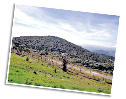
Pidurutalagala Peak
Sri Lanka's highest Mountain and the forest reserve of the topmost
elevation the Pidurutalagala mountain and forest reserve are almost next
to the heart of Nuwara Eliya town.
Nuwara Eliya being a mountain valley consists of a plateau that is
shaped elliptically.
The mountains situated on the plateau rises upto 2,000 feet making
some ridges.
The plateau itself being 6,240 feet above sea level makes the highest
mountain peak, that is Pidurutalagala to attain a height of 8292 feet
(2,527 mts) above sea level.
During 1897, there had been a path made to climb Pidurutalagala
mountain.
The four-mile track to the top could have been made by walking for
two and half hours or could be made on horse back. Women of that time
also had the choice of being carried on a chair which was tied to two
bamboo poles and carried by four bearers all the way up and back!
The British preferred to call this mountain 'Pedro' as pronouncing
the mountain as 'Pidurutalagala' was not an easy task for them.
The meaning of the word Pidurutalagala can be likened to a 'Straw
laden rock'.
Unlike most mountain peaks found in the world around that has a rocky
surface, Pidurutalagala has a flattened mountain peak with pale green
patna covering the whole surface according to eyewitness description of
1940.
During the dry season, the grass dries up and looks like a mountain
top capped with a spread of straw to the distant.
There had been only a single man-made path to the summit and
elsewhere the untouched forest , only with roads that elephants
frequented for thousands of years.
The trees of mountain sides looked like dwarfs as nearing the
mountain top due to high winds that prevailed and the tree tops near
summit all had a flattened effect like being a well trimmed off hedge by
a gardener.
There is a noticeable difference between the character of
Pidurutalagala forest and the lowland forests. The trees here appear to
be that of gnarled trunks with many forked branches with lichens and
moss clinging to them showing cloud forest characteristics.
The man-made path to the top had been marked at regular intervals
throughout the ascent on stone posts such as 7,500 feet, 8,000 feet. In
the 1940s, on the mountain summit there had been a 'Toposcope' or a type
of a map which had a circle of pointed arrows that showed the directions
of certain important places.
During specific times of the year one may be fortunate enough to
travel up to the Pidurutalagala peak after obtaining permission (no
trekking allowed) without stopping the vehicle on the way, or getting
out of the vehicle, from the entrance security point at the mountain
base up to the upper security point at the peak.
-Internet |


")


