On a precarious footing
Six districts identified as being vulnerable to
landslides:
by Dhaneshi Yatawara
Two landslides within six months in Haldummulla in the Badulla
District were warning signals. Six more districts were identified last
week as being highly vulnerable to landslides.
 |
|
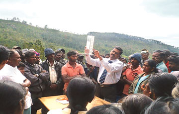
Asst. Director Udaya Kumara
explaining how to use a rain gauge |
 |
|
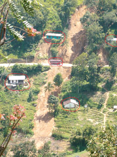
A landslide prone
area in Haldummulla |
Disaster Management experts have entertained fear that the central
mountainous area of the country is in great danger. Unplanned human
activities have been blamed for disturbing the natural ground set up.
Disaster Management officials said people living in these areas not
being aware of the grave situation face the greatest threat.
People living in estates, slopes and mountains in the Badulla
District seem to be facing an uncertain situation. "Unfortunately
despite the pre-warning systems in high risk areas and instructions on
evacuation methods, people tend to forget them in few weeks," said Udaya
Kumara, Asst. Director of the Badulla district Disaster Management
Centre (DMC).
The DMC and the National Building Research Organisation (NBRO)
established automated rain gauges established as an early warning system
in seven high risk areas in the Badulla District.
"The system is created to transmit the information automatically to
DMC and the NBRO offices in Colombo," said Udaya Kumara.
In addition, rain gauge tables have been provided to each Grama
Niladhari Division for the villagers to be alert on the weather pattern
changes. According to Udaya Kumara people have been instructed to be
alert after the rainfall reaches 150mm within 24 hours following
continuous heavy rain. Parallel to the rainfall measurement several
other environment signs such as earthslips and trees falling need to be
taken notice of.
Evacuation plan
"Villagers are told and trained to follow the evacuation plan but the
problem is people do not keep this in mind - they forget," said Udaya
Kumara.
Evacuation plans are set up in villages and villagers are trained
from time to time. The responsible team of the village consists of
Disaster Management Committee and a Civil Defence force. "Periodically
we have carried out drills to inform people of the evacuation plan. Yet
when the real disaster strikes they do not follow it. At times, the land
is about to slide and villagers refuse to move," said Udaya Kumara and
added that this attitude needs to change.
Families have been moved away from the recent landslide - hit area in
the Nikapotha Grama Niladhari Division in Haldummulla. They are now
living with their relatives in other areas in Badulla. The abandoned
rubber plantation devastated by the landslide has no human activities
any more. There are resettlement problems in Miriyabedda due to the lack
of safe lands to be given to the people.
When the National Building Research Organisation started mapping out
Badulla district, certain areas did not show any human activities.
Therefore, they were not given priority.
High risk areas
"The problem started when people commenced work that altered the
natural setting in these high risk areas, said Head of NBRO's Landslide
Research and Risk Management Division, R.M.S. Bandara. Unplanned and
unauthorised human activities in high risk areas have been identified as
the main cause for frequent landslides. Lack of human resources in
disaster management is another problem. A small number of of people
tackling a growing issue of disasters in a district is becoming
unmanageable now.
Dr. Pathmakumara Jayasinghe, a geologist of the Coordinating
Secretariat for Science, Technology and Innovation (COSTI) said that
numerous cracks have been identified on the ground in Haldummulla making
it a landslide-prone area," said Dr. Jayasinghe.
"These underground cracks are in different directions and filled with
water which we call, aquifers. When there are disturbances to aquifers
like making tunnels to extract water, a hole can be created in the
ground when the water drains through these tunnels.
The natural stability of the ground collapses. This can happen when
people dig the ground to make tube wells and dug wells," he said.
In addition to the cracked underground the Badulla and Haldummulla is
well known for its metamorphic rocks which is geologically known as
marble. Underground rocks alter the mineralogy, texture and chemical
composition when exposed to extreme temperature and chemical changes
create these metamorphic rocks.
With the passage of time there are cavities in these rocks to be
filled with water and due to human activities if the water drains from
the cavities, the ground gives way creating a huge hole.
"But to understand the real ground conditions, there should be a
specific geological study. It will help find the exact reason for these
frequent landslides," added Dr. Pathmakumara.
And it is high time to find out whether the central mountains, the
water catchment areas of the country are in danger. |


")


