Sri Lanka included in Google's Street View
When explorer Marco Polo visited Sri Lanka in 1265, he described it
as "the finest island of its size in all the world." Tourists from
around the world agree, as it's an increasingly popular travel
destination, especially for those who want to explore the country's rich
history and natural beauty.
|
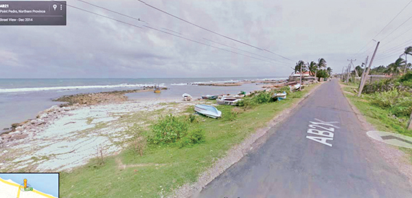
Pic: Courtesy Google |
Now, even more people around the world will appreciate the sites of
Sri Lanka, with the launch of the 'Land of lions' in Google's Street
View. This brings the total number of countries that you can in explore
in 360-degree panoramic imagery to 76.
From the hustle and bustle of downtown Colombo, to the cool tea
plantation hills, to the long white beaches, Sri Lanka's landscape is as
beautiful as it is diverse. To capture this imagery, we drove about
50,000 kilometres, across every province so you can virtually explore
this beautiful landscape from coast to coast. The Bergala tea estates on
the Beragala-Hali Ela main roads home to many of the world's best brews
- people picking tea among the lush rolling hills.
For more jungle and mountain views, take a tour along the Colombo-Kandy
road. Starting in the nation's biggest city, the road has some
spectacular scenery and takes you inland to Kandy.
The Kandy-Jaffna highway heads out to the coast and down to the
Elephant Pass causeway. While you may not see any elephants, this
stretch of road connecting North and South Sri Lanka gives you a 360
degree view of the Indian Ocean on either side of the road.
In the South East, Arugam Bay is a popular surfing spot renowned for
its amazing point break. If you prefer spending time on the sand rather
than on a board, the sleepy little fishing village of Point Pedro on the
northern tip of the island has some pristine beaches to explore.
In Anuradhapura you can catch a glimpse of the ancient Ruwanweliseya
Stupa. It was built in 140 BC and remains one of the world's tallest
monuments, standing at over 100 metres.
- Google
|