|
UNDP’s Integrated Strategic Environment Assessment:
Eco-friendly development for the North
By Shanika SRIYANANDA
|

Nallur Kandaswamy temple
|
New colourful buildings are emerging over the ruins of deadly battles
that took place a few years back in the North of Sri Lanka. They would
no longer be the exhibits which show the gravity of war. After 30-years,
the North has opened up her beauty to the world and invite tourists to
enjoy its unspoilt natural wonder. Investors are exploring more business
opportunities in tourism, hotel, healthcare and every other sector
generating more jobs for people whom suffered enough from terrorism.
At the end of the decades of long suffering, the North has proved its
potential to become one of the major economical hubs in the country. It
is the Uthuru Wasanthaya (Northern Springs) that brought much of the
development to the door-step of the North. As it recorded a rapid
development during the past two-years with the restoration of anomalies
and flourishing new investments, the North now runs the risk of
polluting and damaging its natural environment. The ‘planned
development’ is the key to keep a balance between development and
eco-system.

Charitha Herath |
Dr. Ananda Mallawatantri |
The Northern Province is rich in natural resources - extensive
coastal area, dense forests and mineral deposits. Most of the islands-
Kayts, Neduntivu, Karaitivu, Pungudutivu and Mandativu - around the
country are in the West of the Northern Province.
The new era of development in the North has brought new challenges
for implementing agencies. With no proper data on resources, they were
to answer to questions like - is there sufficient ground and surface
water for industry and human settlements?, what building materials could
be sourced locally and how much could be safely exploited? Which
forests, coastal, wildlife, wetland and archaeological areas should be
conserved?, How would these add value to the proposed development plans,
especially tourism, in this area?
Meeting these challenges is an easy task but the real task is: how to
achieve it without harming the eco-system would remain unanswered
bringing more damage to the untapped eco-systems in the North.
While the development process is going ahead under the Northern
Springs, with the assistance of the UN Development Programme, over 25
agencies involved in water, mineral, archaeological, forest, wildlife,
marine, coastal, urban development, tourism, Telecom, power, roads and
investment got together in November 2009, just after six months of
ending the LTTE, to find answers to those querries to provide strategic
information to expedite the already begun development activities in the
North.
After several field visits and meeting all the stakeholders in the
related fields, they tabled the much needed Integrated Strategic
Environment Assessment (ISEA)’ for the Northern province to facilitate
decision- making on the sustainable use of the natural resource base for
accelerated development. Now, there is a lot of potential for an
economic boom. This is also an area which is eco sensitive. The
potential for eco-tourism is high if development activities are handled
properly”, The Project Leader and Assistant Resident Representative-
Environment, Energy and Disaster Risk Management of the UN Development
Programme Dr. Ananda Mallawatantri said.
He said development programmes focusing on livelihood development of
the economically and socially-shattered Northern Province requires
proper resource mapping.
“ The ISEA for the northern province is thus need to work with a
large number of stakeholder agencies in order to formulate a broad,
multi-sector and multi agency analysis to integrate disaster risk
management into development plans and programs, support development
programs through targeted resources availability studies, allow
systematic data gathering by technical agencies in the field and promote
data sharing, establish limits for safe extraction of natural resources,
identify the ecologically sensitive areas and advocate for their
conservation and complementary uses, develop a medium to long-term
monitoring system to ensure development is ecologically safe”, he said.
 Dr. Mallawatantri told the Sunday Observer that no proper forest and
wildlife boundaries, no data on water, ground water, sand and gravel
resources and no maps on archaeological sites in the Northern region are
available for the last 30-years. Dr. Mallawatantri told the Sunday Observer that no proper forest and
wildlife boundaries, no data on water, ground water, sand and gravel
resources and no maps on archaeological sites in the Northern region are
available for the last 30-years.
He said the ISEA had brought planners, investors, project
implementers, resource managers and users in the province together to
ensure a smooth development process with minimal damage to the natural
resources and the eco-system in the North.
All these agencies presented their own maps, the activities to be
done in future and the intended long-term targets. Dr. Mallawatantri
said the Geological Survey and Mines Bureau (GSMB) has conducted mineral
surveys in all five districts in the North by five specialist teams to
identify both locations and quantities of mineral resources that helps
reconstruction and rehabilitation process in a sustainable and
environmental friendly manner. He said the main task of the GSMB was to
look at the availability and sustainable extraction of potential sand,
clay, quarry metal and other building materials needed for the
development of infrastructure, settlements and industry in the North.
The GSMB has prepared mineral maps for each district and identified
environmentally sensitive sites and their safe extraction limits.
He said as all the agencies had come to a common platform to develop
the North maintaining minimal damage to the rich eco-system and cultural
heritage, obtaining the Environmental Impact Assessments (EIAs) for the
project would be faster as they have followed the ISEA guidelines.
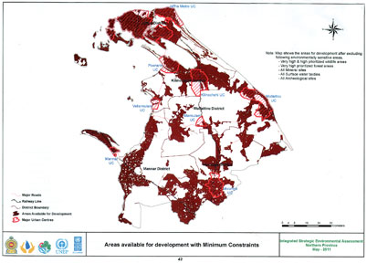
A series of ‘Opportunity Maps’ prepared with available data and
information on natural resources gathered in the field studies to ensure
optimum use of resources for a rapid and sustainable economic
development in the province. These maps will provide tools for planning
and long-term monitoring of the quality and quantity of natural
resources in the region and help planners to address issues such as
climate change.
With the success of the ISEA, President Mahinda Rajapaksa has
requested the UNDP to draw similar ISEAs for the Central and Uva
provinces. The UNDP is also carrying out a similar project for Gampaha
on a request made by the Minister of Economic Development Basil
Rajapaksa as the Gampaha district is becoming one of the industrial hubs
in the Western province. “ If we have more funding, the UNDP would carry
out ISEAs for the remaining provinces”, he said.
Dr. Mallawatantri said the areas in the North where still the
de-mining activities were going on were also included in the ISEA in the
North as it would be over within next three-to four years.
 “ The ISEA is a long term plan to manage a sustainable development”,
he said adding that forest resources in the North, which accounted for a
high percentage of the country’s total forest cover, were largely intact
during the past and from extensive sand dunes in Jaffna peninsula, to
quarry metal and clay for bricks, the province is especially rich in
mineral resources needed for construction. “ The ISEA is a long term plan to manage a sustainable development”,
he said adding that forest resources in the North, which accounted for a
high percentage of the country’s total forest cover, were largely intact
during the past and from extensive sand dunes in Jaffna peninsula, to
quarry metal and clay for bricks, the province is especially rich in
mineral resources needed for construction.
The land is generally flat and undulating with no significant
elevation. Lagoons, bays, salt flats, wetlands, coral reefs, islands and
islets, and estuaries are some of the prominent coastal features that
are important both ecologically and economically.
Government Agent Jaffna Emelda Sukumar said government institutions
when implementing the development projects follow the ISEA and it made
officials to get a clear project of the specific location to be
developed.
The (CEA), which played a major role in implementing the ISEA has
conducted awareness programs with District Secretaries, local
authorities and community leaders in the North to get their support for
the assessment. It also carrying out post ISEA monitoring.
The CEA Chairman Charitha Herath said the ISEA was an important
document that guides the government to accelerate its development
projects in the North.
“ It is already handed over to the government and the project
implementing agencies have to follow the ISEA when carrying out their
development projects”. he said adding that it is a collective effort of
all the government institutes.
If someone claims that the government was doing nothing for the
Northern people, the ISEA is the best proof to show how the government
is committed to a proper development process”, he said. |


")


