Unpredictable
Geological changes?
by Sajitha Prematunge
[email protected]
Our island has always been a peaceful and calm abode, literally
devoid of geological catastrophes. But of late words and phrases such as
earth tremors, tsunami, and landslides have penetrated into the
colloquial jargon. Is it that these geological phenomena were always
there but we failed to notice them, until the tsunami?
|
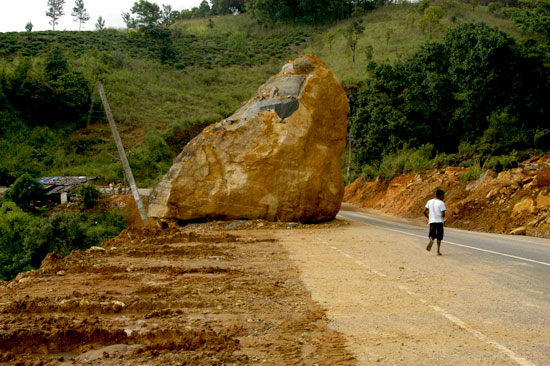
Alterations in the landscape cause landslides
 |
There are records of earth tremors and even of earthquakes, that took
place in Sri Lanka, as far back as 1505 and a series of tremors were
reported from the Mahaweli Sheer Zone in the 1990s. Or has Sri Lankan
geology - reached a vital turning point - in the process of a major
metamorphosis? It’s clear that since the Tsunami Sri Lanka is
experiencing more tremors. Perhaps people are more alert.
However it was also reported that the earthquake that triggered the
legendary tsunami was also able to, slightly alter the momentum of
earth’s rotation.
A series of tremors occurred in Sri Lanka on July 2007 and more
recently in April 2008. The first of which was near Beralihela at around
12.01 am and another 02.00 pm on 9th July 2007. The second couple with a
5.2 magnitude was an underwater earth tremor east of Pothuvil, at around
9.57 am on 18th July 2007.
The third couple reported from the same area of Beralihela, occurred
around 5.50 am and 6.45 pm on 20th July 2007. The most recent tremor
occurred at 12.14 pm 07 April 2008 in the Dambulla area measuring less
than 3 on the Richter scale. Only detected by the Pallekele seismograph,
proves that it was a minor local tremor too low in magnitude to have
been detected by any of the Global Network Stations.
Geologists of the Geological Survey and Mines Bureau (GSMB) told the
Sunday Observer that due to the lack of data, the epicentre could not be
determined, but could be anywhere in a 60 to 65 mile radius from the
Pallekele station.
The true cause of these recent tremors are still uncertain. Sri Lanka
is not situated in a tectonic plate boundary. Considering the
geographical setting of Sri Lanka, it’s improbable that the island could
experience extensive damage due to a major earthquake.
The nearest active plate margin is the Sunda trench, located
approximately 1500 km from Sri Lanka and the only other potential threat
lies in Makran Thrust zone near Oman. Although direct threats due to
earthquakes are almost insignificant, Sri Lanka suffering from secondary
threats like tsunami again, is very much a possibility.
However Intraplate earth tremors are a plausible explanation. The
pent up pressure from the ‘defuse deformation zone’ could be one of the
causes of the earth tremors in Sri Lanka. On the other hand the Sri
Lankan land surface is covered by hundreds of fractures or faults.
Another plausible explanation is that the tremendous pressure
administered by colossal reservoirs of the dry zone, caused some
metamorphosis in the faults, which in turn induced the tremors. These
are termed as reservoir-induced seismicity.
The biggest obstacle geologists of Sri Lanka are confronted with,
while studying seismic activity, is the lack of proper equipment. When
the tremors of Thissamaharama occurred there were three seismographs in
the island but only one was in working order.
The more recent Dambulla tremor was only detected by the Pallekele
station. Without the proper equipment to detect our own earthquakes,
it’s impossible to determine the epicentre or the exact magnitude of a
below 4 earthquake.
There are more than 125 Global Seismic Network (GSN) Stations around
the globe with near uniform spacing, providing information on seismic
activity around the world. But the establishment of a well-maintained
seismic network - dedicated to the study of micro-seismic activities
within Sri Lanka - is of utmost importance.
Geologists say that in order to accurately determine the epicentre at
least three seismographs, suitably located, should be in operation in
the island around the clock in order to gather real-time data.
An extensive seismic network for Sri Lanka has been proposed by the
GSMB, in order to make it easier to detect, study and analyze seismic
activity and determine whether there is a link between the recent
seismic behaviour and the islands structure.
To determine whether the tremors are reservoir-induced, extensive
research is essential. Minor geological events in and around the country
are also known to be threats in terms of triggering landslides,
especially in the rainy seasons.
Landslides are more commonplace in Sri Lanka than earth tremors. In
the wake of the rains during April a chain of landslides killed many
people and left many others homeless.
In April 26 and 27 land slides were reported from Ingiriya - which
killed five people, Eheliyagoda, Avissawella, Kegalle and Yatiyantota.
Mrs. Kumari Weerasinghe, Scientist of the Division for Land Slides,
National Building Research Organization (NBRO), told the Sunday Observer
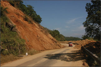
that this is due to no natural phenomenon, but human activities.
“Often hills are sliced off in half to make way for houses. Leaving a
precarious chunk of unsupported soil looming over the houses. By
altering the natural slope of the landscape, natural geomorphology is
affected.”
This coupled with the heavy and incessant rains increase the chances
of landslides. Faults on the land surface, steep slopes, frequent
fluctuations in the underground water level and on instances where the
topsoil layer is heavier than the bottom, the risks of landslides are
heightened.
Disturbing the soil by planting short-term crops loosens the soil and
facilitates the absorption of water. Changing the geomorphology, poorly
managed drainage systems, unsuitable constructions on steep slopes are
some of the human activities that induce landslides.
“Earlier all the canals were stone lined. But the soil of most of the
new canals are exposed, causing moisture to seep into the soil.”
Residents, especially those who are directly below landslide prone
slopes, are at great risk. Land slide prone areas can be identified by
expanding cracks on the ground surfaces and the houses on the slopes,
“Which indicate that there is some kind of movement below the surface.”,
if buildings and trees of a certain area is slanting towards the slope,
if existing springs disappear and new ones emerge and avalanches of
rocks occur the surrounding area may be prone to landslides.
If a certain area shows these signs inhabitants of the area may be in
danger of a landslide and should inform NBRO immediately. And as
temporary solutions should attempt to cover the cracks with a water
resistant material such as cement or clay and clear clogged waterways.
“But the best thing to do would be to inform the NBRO, so we can provide
suitable solutions according to the situation and location.” Advised
Weerasinghe. |