|
Landmarks:
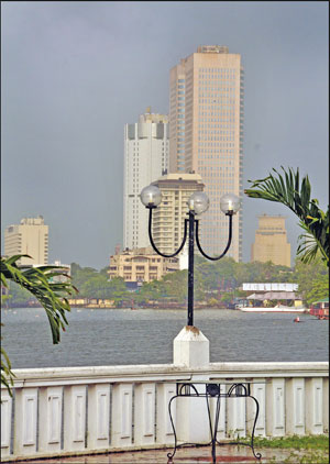
The Beira Lake's rich history
The Beira Lake is not an unfamiliar place to most of us but very few
may be aware of its history - from its beginning in the 16th century.
With the Government's plans to develop this lake into a tourist zone
(News item appeared on September 11 in the Junior Observer) we decided
to enlighten you about this famous lake and also clear out any
misconception you may have had about the origin and history of the Lake.
 I
thought that Colombo's Beira Lake was a natural lake unlike the Kandy
lake which is man-made, until I read a reference to this lake five or
six years ago, in a translation of a book by a Portuguese priest, Father
Fernao de Queyroz.Father Queyroz says, "when Vijaya Bahu laid seige to
Colombo in 1522, the Portuguese captain, Lopo de Britto pursued the
attackers, killing and wounding them, till they reached a stream, which
was afterwards dammed into a lake for the better fortification of the
city." I
thought that Colombo's Beira Lake was a natural lake unlike the Kandy
lake which is man-made, until I read a reference to this lake five or
six years ago, in a translation of a book by a Portuguese priest, Father
Fernao de Queyroz.Father Queyroz says, "when Vijaya Bahu laid seige to
Colombo in 1522, the Portuguese captain, Lopo de Britto pursued the
attackers, killing and wounding them, till they reached a stream, which
was afterwards dammed into a lake for the better fortification of the
city."
This "stream" was a distributary of the Kelani Ganga, and was known
as Kolon Ganga.
A distributary is a stream or small river that flows out of the main
river and discharges the water into the sea. River deltas are formed by
these distributaries.
This small river would have branched off the Kelani Ganga at
Sedawatta or thereabouts, flowed along the low-lying land past
Dematagoda and into the sea at a point north of the present harbour.
Kolonnawa, a town to the south of the Kelani Ganga is known by that name
because the Kolon Ganga flowed through that area.
At the mouth of the Kolon Ganga was a small port, Kolontota, like
Gintota at the mouth of the Gin Ganga, north of Galle. It was at
Kolontota that the Portuguese landed in 1505. Even then it was a busy
trading port, much used by Arabs. The dam that the Portuguese built
across the Kolon Ganga is gone, but its memory lives on, in a street
name, Dam Street in Colombo Central.
Portuguese Era
Father Queyroz gives us more information about the lake. In 1555, the
Portuguese built some houses making Kolontota "a city surrounded by a 'Calapana'
(a lake) nearly three leagues and a half in length." (A league is about
three miles). The writer says that one had to cross the water to get to
the city and that in some places the water was upto a man's waist.
In 1578 Mayadunna, the King of Sitawaka brought his army and camped
on the bank of the lake. He wanted to cut off food supplies to the
Portuguese, which were brought in boats, starve them and force them to
surrender. He attempted to drain the lake but failed.
His son, Rajasingha beseiged Colombo a few times and drained the lake
twice by cutting canals, one of these is the San Sebastian canal in
Maradana. The Portuguese did not surrender.
There were, at that time, many islands in the lake. Don Jeronimo de
Azevedo, the Portuguese Captain General had a house in one island. He
came there to relax, enjoying the cool breeze blowing across the lake.
One island was large enough to have 600 coconut trees and a whole
village. The present Polwatta, the suburb behind 'Temple Trees', the
President's residence, must be part of that island.
The lake was the scene of many battles; first between the Sinhala and
the Portuguese and later between the Portuguese and Dutch and Dutch and
British. In 1656, the Dutch came in boats via the Kelani Ganga and
attacked the Fort and the houses outside the Fort. For six months they
kept on firing their guns. The wall surrounding the Fort was broken down
and the churches, houses and store-houses inside the Fort were reduced
to rubble.After seven months of fighting the Portuguese surrendered and
with that their rule in Lanka ended.
Dutch period
 The
Dutch who now occupied the Fort didn't re-build the wall (The wall was
built much later). Instead they built a fence-stockade - on higher
ground some distance away from the old wall. The result - the Fort
became smaller and the lake larger. The low-lying land outside the Fort
was flooded and the lake now extended to Kayman's gate in the present
day Pettah. The
Dutch who now occupied the Fort didn't re-build the wall (The wall was
built much later). Instead they built a fence-stockade - on higher
ground some distance away from the old wall. The result - the Fort
became smaller and the lake larger. The low-lying land outside the Fort
was flooded and the lake now extended to Kayman's gate in the present
day Pettah.
This part of the lake was infested with crocodiles, hence the name
Kayman. It is a word for crocodile in Portuguese and Spanish. An island
in the Caribbean (West Indies) is known as Cayman island. The enlarged
lake was connected by canals "with the Kelani river to the north and
with Bolgoda lake and Panatura river to the south." The town outside the
Fort was called Aut Stad. Today's Pettah is the Aut Stad.
The Dutch controlled Colombo and the low-country for 140 years from
1656. The British who were now in the Indian Ocean started attacking the
Dutch in 1795. They too came across the lake. The Dutch fought back but
it was not a long battle. On February 7, 1796 the Dutch surrendered and
the period of Dutch rule in the low country ended. (Another 19 years
passed before the British took full control of the whole of Lanka).
British period
When the British took control of Colombo the lake was 400 acres in
extent. Here and there in the lake were small islands. Slave Island was
one such island and it was called by that name because the slaves who
worked in Dutch houses were sent there for the night. The Dutch had
grown cinnamon on that island.Captain's Garden, the slightly high ground
between Fort and Maradana Railway Stations, where there is a Hindu Kovil
now, was an island then. In that island was a fresh water well that
supplied drinking water to the officers and residents in the Fort.
The water was brought by black people in leather bags called 'puckally
bags.'
From accounts left by army officers, by residents and visitors we
learn that in the early days of British rule, the "blue lake of Colombo"
was a beautiful place, that many streams fed the lake and it extended up
to four or five miles in a north easterly direction. The lake was an
ideal place for boating. Those residing on the banks of the lake went by
boat to their work places in the Fort. There were frequent parties and
sporting events on the bank.
When news reached Ceylon that the British had defeated Napolean, a
ball was held on the bank to celebrate the victory.For about fifty years
Colombo didn't change much. The change came in the 1860s. The first
train from Colombo to Ambepussa ran in 1865. The construction of the
railway line must have started at least in early 1864. The railway
station was at the eastern (Maradana) end of the lake.
The Colombo Municipal Council was established in 1865. About 20 years
later land by the lake began to be sold to commercial companies. They
wanted land on the lake front because it was easy to transport their
goods - barrels of coffee and bales of cinnamon and spices - by boat to
the harbour. The canal by Lake House on its left, is one canal along
which the boats went to the harbour. Today only names remain to tell us
what and what areas were part of the lake or its shore. The land where
St. Joseph's College stands and the surrounding area was known as
Suduwella - white sandy shore. There is still a Municipal ward by that
name. Today there isn't one square metre of white sand left of that once
white sandy shore.
As the population of Colombo increased so did the garbage. Much of it
went into the lake and the water got polluted. The garbage on the bank
gave out a horrible stench and was the breeding ground of mosquitoes and
flies. It was this stench and mosquito-fly menace that led to the
closing of the school - Colombo Academy sited near the lake. It was
re-opened in Cinnamon Gardens under a new name - Royal College.
Henry Trimen, the author of 'A Handbook of the Flora of Ceylon'
observed a great variety of plants in the lake, in 1879. Twelve years
later they were all gone.
The water was so polluted with more and more buildings coming up on
the water front and the population increasing the lake got more and more
polluted.
After Independence
 The
selling of land on the lake front continued into the 1990. In the last
two decades of the 20th century, hotels, banks and Government offices,
came up on the banks of the lake, some five, six, storeys high. Now
those going on D. R. Wijewardene Mawatha or Chittampalam A. Gardiner
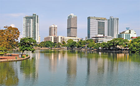
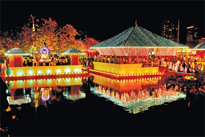
Mawatha hardly get a glimpse of the lake. Only the part of the lake
where the 'Seema Malaka' is can be seen.Hotels, printing presses, food
processing factories, beverage manufacturies and slums round the lake
were diverting their polluted water into the lake. But, the major source
of pollution was the raw sewage that was sent into the lake. The
selling of land on the lake front continued into the 1990. In the last
two decades of the 20th century, hotels, banks and Government offices,
came up on the banks of the lake, some five, six, storeys high. Now
those going on D. R. Wijewardene Mawatha or Chittampalam A. Gardiner
Mawatha hardly get a glimpse of the lake. Only the part of the lake
where the 'Seema Malaka' is can be seen.Hotels, printing presses, food
processing factories, beverage manufacturies and slums round the lake
were diverting their polluted water into the lake. But, the major source
of pollution was the raw sewage that was sent into the lake.
What was once an ornament to the city had by 1990s become a health
hazard.Work on the restoration of the lake with World Bank aid started
at the turn of the century. The lake was dredged, algae destroyed, algae
eating fish introduced and underserved settlements by the lake,
improved.
The name
It was only after 1927 that the lake began to be called Beira Lake.
That year the word Beira appeared on a map. Until then the lake was
called Colombo Lake or just the lake.Beira - it is an unusual word. What
does it mean? Beira is a Portuguese word. There is in Portugal a
province called Beira. (Times World Atlas map 76). As defined in the
Portuguese dictionary that I looked up beira is 'brink or bank of any
water.' Beira is also the name of a coastal town in Mozambique, once a
Portuguese colony.We have another Beira. Berathuduwa, Point de Beira
near Balapitiya. It is interesting to find out how that village/town got
that name.
- Sumana Saparamadu |


")