Indonesia hotbed of natural disasters
You may have seen or heard reports in the media recently that several
volcanoes in Indonesia have erupted over the past weeks. Indonesia is a
hotbed of natural
 disasters, as you may know, with quite a large
percentage of the world’s earthquakes, volcano eruptions and tsunamis
taking place in and around this region. Who can forget the 2004 Boxing
Day tsunami when nature’s fury was witnessed by the whole world at its
fiercest? This tsunami too, as you may all know, was caused by an
underwater earthquake off Indonesia’s Banda Aceh region. disasters, as you may know, with quite a large
percentage of the world’s earthquakes, volcano eruptions and tsunamis
taking place in and around this region. Who can forget the 2004 Boxing
Day tsunami when nature’s fury was witnessed by the whole world at its
fiercest? This tsunami too, as you may all know, was caused by an
underwater earthquake off Indonesia’s Banda Aceh region.
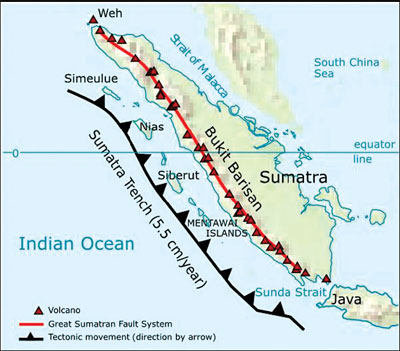
The reason for Indonesia’s high probability for natural disasters is
that it lies in the ‘Pacific Ring of Fire’, an arc of volcanoes and
fault lines around the Pacific Basin.
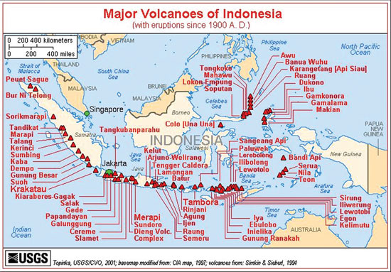
The country has over 130 active volcanoes, more than any other
nation. They make up the axis of the Indonesian island arc system, which
was produced by the north-eastward subduction (a geologic process in
which one edge of a crustal plate is forced below the edge of another)
of the Indo-Australian Plate. A majority of these volcanoes lies along
Indonesia’s two largest islands, Java and Sumatra which are separated by
the Sunda Strait.The names of the volcanoes which have become active
recently, Mount Soputan, Lokon, Karangetang and Gamalama, may not be
very familiar to most people in Sri Lanka, but they are some of the most
active volcanoes in the East Asian nation.
The first three are in north Sulawesi while the fourth is in the
Maluku Islands. Volcanologists (people who study volcanoes) believe that
the four volcanoes may be displaying rising levels of activity due to
the impact of the recent earthquake in neighbouring Philippines.
*Soputan* is a stratovolcano (a volcano composed of alternating
layers of lava and ash) in the northern arm of the island of Sulawesi’s
South Minahasa district, about 2,160 kilometres (1,350 miles) northeast
of Jakarta. It sits on the southern rim of the Tondano caldera (a
cauldron-like volcanic feature usually formed by the collapse of land
following a volcanic eruption) on an elevation of 1,784 m (5,853 ft).
Formed in the Quaternary period, it is one of the most active
volcanoes in Sulawesi with eruptions occurring in 1785, 1819, 1833,
1845, 1890, 1901, 1906, 1907, 1908–09, 1910, 1911–12, 1913, 1915, 1917,
1923–24, 1947, 1953, 1966–67, 1968, 1970, 1971, 1973, 1982, 1984, 1985,
1989, 1991–96, 2000–03, 2004, 2005, 2007, 2008 and 2011. The 2011
eruption saw ash and smoke spewing about 5,000 metres into the air.
The eruption this month saw ash and smoke shooting nearly 1½
kilometres (one mile) into the sky. The volcano remained on a
government-ordered standby alert status, or just one rung below the most
severe alert level, after the eruption. People had been evacuated from
the area and asked to remain vigilant.
|
Gamalama volcano |
However, no casualties were reported *Mount Lokon*, together with
Mount Empung, is a twin stratovolcano (2.2km/1.4 miles apart) in Tomohon,
northern Sulawesi, 10 km (six miles) south of Manado. Both rise above
the Tondano plain and are among the active volcanoes of Sulawesi. Mount
Lokon has an elevation of 1,580 m (5,184 ft) and a flat and craterless
top. Lokon formed during a period of andesitic (gray, fine-grained
volcanic rock)volcanism on ring fractures resulting from the Tondano
caldera’s early to mid-Pleistocene collapse. Recently-erupted material
remains andesitic in composition and consists of ash plumes and, less
commonly, pyroclastic (rock fragments of explosive origin, especially
those associated with explosive volcanic eruptions) flows and lava
domes.
Lokon has erupted several times in the recent past, with an explosion
in July 2011 forcing more than 5,200 people to be evacuated. The volcano
again began showing signs of activity this February and on September 19.
An eruption occurred in the morning of that day, spewing superheated
volcanic material up to 600 metres and ash up to 3,500 metres into the
atmosphere, forcing authorities to ban all human activities within a
2.5-kilometre radius of the crater. There were fears that the active
volcano could erupt anytime and people were asked to remain vigilant
while the authorities continued to monitor the volcano.*Mt. Karangetang
*(also known as Api Siau) in the Sitaro Islands district in Siau across
the northernmost tip of Sulawesi is a stratovolcano with an elevation of
1,827 m (South Peak) and 1,784 m (North Peak). It contains five summit
craters along a North-South line. The island is home to about 22,000
people.
Karangetang is one of the most active volcanoes in Indonesia, having
erupted 41 times since 1675. A pyroclastic flow in 1997 killed three
people. It erupted again on March 11, 2011, a few hours after the
earthquake in Japan and the resultant Pacific-wide tsunami. There were
no reports of serious damage or deaths, though lava and hot gas clouds
were emitted onto its slopes The volcano is notorious (well known,
usually for some bad quality) for building lava domes and producing
dangerous pyroclastic flows.
The volcano saw five eruptions in the 20th century (1940, 1972, 1976,
1983 and 1991) which caused fatalities. The area around the volcano
contains fertile soil where people have carried out agriculture
activities. Residents have now been warned not to climb beyond 500
metres of the mountain. About 110 people were evacuated from the slopes
and the North Sulawesi administration had sent relief supplies to them.
*Gamalama* (Peak of Ternate) is a near-conical stratovolcano that
comprises the entire island of Ternate off the western coast of
Halmahera in the north of the Maluku Island. The island of Ternate was a
major regional centre in the Portuguese and Dutch spice trade for
several centuries, which contributed to the thorough documentation of
Gamalama’s historical activity..

Mount Lokon has a flat and craterless top |
Mount Karangetang |
Three cones, progressively younger to the north, form the summit of
Gamalama, which reaches 1,715 metres (5,627 feet). Several maars (broad,
low-relief volcanic craters) and vents define a rift zone, parallel to
the Halmahera island arc.
Eruptions, recorded frequently since the 16th century, typically
originated from the summit craters, although flank eruptions have
occurred in 1763, 1770, 1775, and 1962-63.
In December 2011 Mount Gamalama erupted, ejecting material up to
2,000 metres into the air. Thousands of residents in nearby Ternate City
fled due to ash and dust particles raining down on the town. Four people
died and dozens were injured from debris falls (*lahar)* while more than
100 houses were destroyed. Many farmers were left devastated after a
thick layer of ash smothered fruit trees and crops. An eruption in 1775
caused the deaths of 1,300 people.
This month, the mountain spewed a white column of ash about 1,000
metres into the atmosphere while also throwing some volcanic debris,
though on a smaller scale. Local volcanology authorities had declared a
2.5 kilometre exclusion radius around the crater of the erupting
volcano. The alert level for Mount Gamalama had been raised to standby.
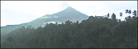
Meanwhile, Indonesians have also been getting worried over increased
activity, especially rumblings over the past weeks, from the 2,968-metre
Mount Merapi in Central Java. The rumblings in the evening are
accompanied by shaking of the ground and thick columns of ash billowing
from its crater.
However, no warnings have been issued in this area so far with
officials describing the rumbling sounds from the volcano as almost
routine in the area and the situation as “still safe”.Merapi last
erupted in October 2010, killing more than 300 people and forcing
350,000 to evacuate.
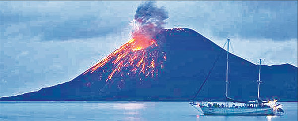
Anak Krakatau in Lampung in the Sunda Strait between Java and Sumatra
also showed some signs of activity earlier this month. The volcano is
the remnant of Krakatau, the site of an earth-shattering eruption in
1883. Anak Krakatau means ‘Child of Krakatau’ in the local language*. -
IT* |


")


