The science behind the Nepal earthquake
Nepal continues to rattle following the April 25 earthquake that
destroyed housing in Kathmandu, damaged World Heritage sites, and
triggered deadly avalanches around Mount Everest. Nepal is particularly
prone to earthquakes. It sits on the boundary of two massive tectonic
plates - the Indo-Australian and Asian plates. It is the collision of
these plates that has produced the Himalaya mountains, and with them,
earthquakes.
Our research in the Himalaya is beginning to shed light on these
massive processes, and understand the threat they pose to local people.
The April 25 quake measured 7.8 on the moment magnitude scale, the
largest since the 1934 Bihar quake, which measured 8.2 and killed around
10,000 people. Another quake in Kashmir in 2005, measuring 7.6, killed
around 80,000 people.
These quakes are a dramatic manifestation of the ongoing convergence
between the Indo-Australian and Asian tectonic plates that has
progressively built the Himalayas over the last 50 million years.
They are but one reminder of the hazards faced by the communities
that live in these mountains. Other ongoing hazards include floods and
monsoonal landslides, as exemplified by the Kedarnath disaster of 2013
which killed more than 5,000 people.
Earthquakes occur when strain builds up in Earth's crust until it
gives way, usually along old fault lines. In this case the strain is
built by the collision or convergence of two plates.
|
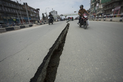
A crack in a road near Kathmandu caused by the earthquake.
EPA/ Hemanta Shrestha (This article was originally published
in The Conversation) |
A number of factors made this quake a recipe for catastrophe. It was
shallow: an estimated 15km below the surface at the quake's epicentre.
It saw a large movement of the earth (a maximum of 3m). And the ruptured
part of the fault plane extended under a densely populated area in
Kathmandu.
From the preliminary analysis of the seismic records we already know
that the rupture initiated in an area about 70km north west of Kathmandu,
with slip on a shallow dipping fault that gets deeper as you move
further north.
Over about a minute, the rupture propagated east by some 130km and
south by around 60km, breaking a fault segment some 15,000 square
kilometres in area, with as much as 3m slip in places.
The plates across this segment of the Himalaya are converging at a
rate of about 2cm this year. This slip released the equivalent of about
a century of built up strain.
Predicting quakes
While the occurrence of large earthquakes in this region is not
unexpected, the seismological community still has little useful
understanding of how to predict the specific details of such ruptures.
While the statistical character of earthquake sequences is well
understood, we are still unable to predict individual events.
Questions as to why such a large earthquake, in this specific
location at this time, and not elsewhere along the Himalaya, continue to
baffle the research community, and make for problematic challenge of
better targeted hazard preparedness and mitigation strategies.
But with each new quake researchers are gaining valuable new
insights. As exemplified by the ready availability of quality data and
analysis in near real time provided by organisations such as the United
States Geological Survey and Geoscience Australia, the global network of
geophysical monitoring is providing an ever more detailed picture of how
the earth beneath our feet is behaving.
Seismic gaps
New techniques are also helping us read the record of past
earthquakes with ever greater accuracy. Our research collaboration -
involving the University of Melbourne, the Jawaharlal Nehru Centre for
Advanced Scientific Research and the Indian Institute of Science in
India, the University of Victoria in Canada, and the Bhutan Government -
is studying the earthquake geology of adjacent areas of the Himalaya in
the state of Uttarakhand in India and in Bhutan.
Together we are mapping indicators of tectonic activity that link the
earthquake time-scale (from seconds to decades) to the geological
time-scale (hundred of thousands to millions of years).
Using new digital topography datasets, new ways of dating landscape
features and by harnessing the rapidly growing power of computer
simulation, we have been able to show how large historical ruptures and
earthquakes correlate with segmentation of the Himalayan front reflected
in its geological makeup.
This is shedding new light on so-called seismic gaps, where the
absence of large historical ruptures makes for very significant concern.
The most prominent segment of the Himalayan front not to have
ruptured in a major earthquake during the last 200-500 years, the
700-km-long "central seismic gap" in Uttarakhand, is home to more than
10 million people. It is crucial to understand if it is overdue for a
great earthquake.
Our work in Uttarakhand and elsewhere is revealing how the rupture
lengths and magnitude of Himalayan quakes is controlled by long-lived
geological structures. While little comfort to those dealing with the
aftermath of Saturday's tragedy, it is part of a growing effort from the
international research community to better understand earthquakes and so
help mitigate the impact of future events.
Funded as part of the Australian Indian Strategic Research Fund and
DFAT aid programs, our collaborative work is a reflection of the
commitment of our governments to international earthquake research. |


")


