Coming to grips with nature's fury
by Maneshka Borham
In the aftermath of the worst disaster in a decade, Sri Lankan
experts began forecasting the future, including the island's
vulnerability to flooding, cyclones and landslides.
 |
|
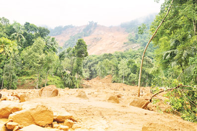
Trees uprooted in a
landslide in Aranayaka
Pic: Nirosh Batepola |
Sri Lanka mainly experiences flash floods and fluvial or river
floods. Flash floods are caused by heavy rainfall. Independent of an
overflowing water body, river floods occur when excessive rainfall over
an extended period of time causes a river to exceed its capacity.
Unfortunately, the island experienced both types of flooding a
fortnight ago, affecting many urban and semi urban areas in the Gampaha
and Colombo Districts, when the country experienced the worst flood
since 1989.
According to Prof. P.K.S. Mahanama, Department of Town and Country
Planning, Moratuwa University, recent floods were mainly the result of
improper town planning. "We must understand the river function," he
said, adding that development should not hamper the natural flow of a
river, as such disturbances may cause river flooding. He noted, while
there are many riverfront cities in the world, they remain safe as long
as encroachment on a river's command area has not taken place.
Landslide vulnerability
Prof. Mahanama said, the estuary of a river should be free of any
settlements. "The British developed the Colombo city as a port. We have
mindlessly developed on either side of the Kelani River, and narrowed
the estuary area."
Colombo needs 1,000 acres of land for water retention but has only
600 acres at present, he said. Filling marshlands for development is
another contributor to urban flooding with floods turning severe due to
Colombo's inability to absorb flood waters due to land-filling.
Landslides, according to R.M.S Bandara, Head of the Landslides
Research and Risk Management Division of the National Building and
Research Organization (NBRO), occur largely due to a combination of
factors. "Landslides are the result of various physical, morphological
and geological causes," he said, adding that bad land use practices,
improper water or drainage management and non-engineered constructions
were the leading man-made causes, while deforestation, mining,
vibrations caused by excavation and pollution also contribute.
Identifying the exact reasons for the Aranayake landslides is still
to be determined conclusively, he said, while geological research is
being carried out.
The NBRO issues clearance certificates, handles rain gauges,
landslide hazard zone mapping, creates awareness programs, issues
landslide warnings and research. It is empowered to take action against
constructions without NBRO certification in designated areas.
"There are various constructions in landslide-prone areas that lack
proper retaining structures, he noted, adding that people in areas of
landslide risk should adhere to best practices in rainwater management.
Meanwhile, unknown to the general public, the city of Colombo still
relies on the flood water control system put in place by the British in
1925. "This system still works and the Colombo city is well-protected
from river flooding," said G.K. Pathmakeerthi, Director of Irrigation,
Western Division.
He explained the flood control system divisions as major and minor
systems. "The major flood control system protects Colombo, Kelaniya and
Jayawardenepura."
Affected areas in Colombo such as, Sedawatta are meant to be the
Kelani River's estuary and therefore, not protected by these systems, he
added. According to him, areas upstream such as Meethotamulla and
Kaduwela are supposed to be covered by the minor flood control system.
However, during a major rainfall, minor flood control systems fail due
to the loss of paddy fields and marshlands that absorb excess water. "We
had an agriculture-based system and depended on paddy fields for water
retention," he explained. Rapid urbanization has changed the character
of urban areas and this requires urgent upgrading of systems.
Flood control
He added: "Major flood protection systems need to be improved to
include unprotected areas. But, it will require occupation of a large
amount of land. People living in these unprotected areas have become a
major concern today," he noted.
In Prof. Mahanama's view, land should be occupied for flood
mitigation in low-lying areas. "An ingenious solution is needed to
control flooding. We need a proper drainage plan. A bund or barrier
should be built along the Kelani River to withstand critical flood
levels, ideally about 9.2 feet in height," he proposed.
"We can use this bund for transport and it can even be a solution for
easy travel from Kaduwela to Colombo. Pumps could be installed along the
bund to pump out excess water in a controlled manner," he added.
Relocation of families
However, for this plan to work, relocation of families in these areas
to perhaps apartment complexes is a necessity. "The Gin Ganga is a good
example and it now protects the Galle city from flooding," he explained.
According to Pathmakeerthi, the Department of Irrigation is now
looking at options to mitigate flooding. "President Maithreepala
Sirisena has requested a report in two weeks on the matter," he said,
adding that a study will be done of the Kelani basin, subsequently.
NBRO's Senarath Bandara holds the view that mitigation is possible
through proper water table management, providing ground support to
landslide risk areas such as ground nailing and soil binding. During
mitigation, landslide-prone areas should be identified and preventive
measures taken to restructure the soil mass.
"The NBRO does a lot of landslide mitigating work through geometric,
hydrological, chemical and mechanical methods, and has successfully
mitigated a large number of landslides in risky areas, using new
technology," he said. "Methods such as construction of retaining
structure and surface drainage, installation of automatic rain gauges,
extensometers and strain gauges are all part of that, while other
non-structural methods too are used," he said.
Experts also believe hazard mapping and increasing forest cover in
such areas can save lives.
"Landslides occur across the world and despite mitigation efforts,
they can occur in hazardous areas, as prevention is impossible sometimes
against natures' fury," Bandara said. |