|
GEO Facts:
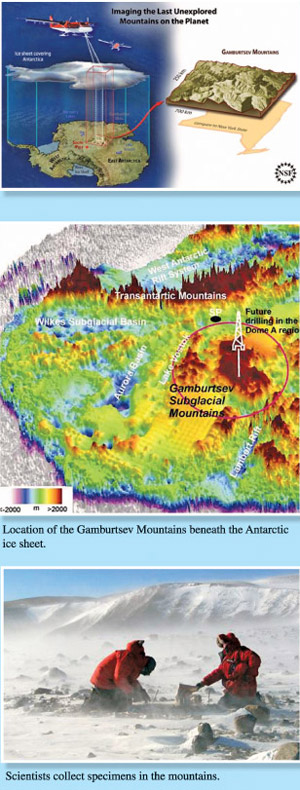
Gamburtsev
Mountain buried in snow
Would you believe that a mountain range that is as big and high as
the Alps in Europe existed in the southernmost continent of Antarctica
and was unknown to anyone until it was 'discovered' as late as 1957?
Yes, the Gamburtsev Mountain range remained unknown and undiscovered
until the Third Soviet Antarctic Expedition found it with a little help
from seismic sounding equipment. The discovery of the huge and
mysterious "ghost range", buried beneath miles of snow, was made during
the International Polar Year in 1957-58.
 It
was named after Soviet geophysicist Grigoriy A. Gamburtsev (1903-1955).
Since then the region remained largely untouched till a 2008 expedition
conducted by researchers from Antarctica's Gamburtsev Province (AGAP).
The seven-nation effort to gather more information about the subglacial
mountains was conducted as part of the projects for the International
Polar Year (2007-09). It
was named after Soviet geophysicist Grigoriy A. Gamburtsev (1903-1955).
Since then the region remained largely untouched till a 2008 expedition
conducted by researchers from Antarctica's Gamburtsev Province (AGAP).
The seven-nation effort to gather more information about the subglacial
mountains was conducted as part of the projects for the International
Polar Year (2007-09).
The Gamburtsevs are 1,200 kilometres long (about the size of the
state of New York) and believed to be about 2,700 metres high; they are
completely covered by over two kilometres of ice and snow, deep within
Antarctica's eastern interior. The current speculated age of the range
is over 34 million years and possibly 500 million years. Current models
suggest that the East Antarctic Ice Sheet (EAIS) was formed from the
glaciers that began sliding down the Gamburtsev range at the end of the
Eocene period. Valleys in the range are said to be twice as deep as
those of the Alps.
The huge peaks of the range have stumped scientists, because high
mountains are usually the result of collisions between tectonic plates
and it is a surprise to see them in the centre of an ancient continent.
It is thought that the EAIS, the largest mass of ice in the world
which measures 10 million square kilometres, formed around the
Gamburtsev Mountains.
Mission completed
The AGAP team of scientists announced the completion of their mission
in February 2009. Modern remote-sensing technology had revealed a rather
jagged landscape. It was also found that the mountains were not only
similar to the Alps in dimension, but that they were also similar in
aspect with sharp peaks and valleys which were remarkably similar to the
Alps. The gathered data was to be analysed by researchers in the
following months.
The AGAP project comprised scientists, engineers, pilots and support
staff from Australia, Canada, China, Germany, Japan, the United Kingdom
and the United States. Two field camps had been established deep within
the Antarctic interior and aircraft flew across the ice, mapping the
shape of the sub-glacial mountains using an ice-penetrating radar. The
local gravitational and magnetic fields had also been measured.
Information was recorded on a network of seismometers that picked up
earthquake signals passing through the rock from the opposite side of
the planet. Data analysed upto December 2009 indicate that the mountain
range is oriented southwest to northeast, and arose from tectonic plate
activity.
Sophisticated airborne radar technology, gravimeter and magnetic
field sensors and other Information Age tools were used to "peel away"
the more than 2.5 miles (4 kilometres) of ice covering the peaks. The
survey covered over 20 per cent of the area mass of this previously
unexplored and incredibly inhospitable area.
The scientists believe that the mountains are the birthplace of the
EAIS and that the research will help them understand one of Antarctica's
last major mysteries. Over 30 million years ago ice began to grow around
the peaks, eventually burying the range and its surrounding lakes.
Newest images
The newest images of the Gamburtsev subglacial mountains were
presented at the International Polar Year conference in Oslo, Norway
last month. The survey images clearly show the high-relief, alpine-style
landscape of the mountains and the network of valleys branching across
them. The profiles show that the valleys were carved by fluvial (river)
as well as glacial activity.
The AGAP team believes that the valleys were initially eroded by
rivers, which points to the fact that the mountains were there long
before the ice began to form, about 35 million years ago. As
temperatures fell, glaciers formed on the highest peaks and followed the
path of the existing drainage system.
But the fact that the mountain peaks have not been eroded into
plateaux suggests that the ice sheet could have formed relatively
quickly.
As it accumulated, the ice sheet carved the imposing Lambert Rift
that can be seen on the images at the edge of the range. This underlies
a branch of the Lambert Glacier, the largest in the world, and is the
site of the sheet's thickest ice, around 4.8km deep.
Amazingly, the radar also showed that liquid water is present under
the ice. Scientists had to endure surface temperatures of around -30
degrees Celsius during the survey, but the temperature under the ice was
as high as -2 degrees Celsius.
Scientists said, "This is because the ice acts like a blanket.
Geothermal heat is trapped and can't readily escape because of the
thickness of the ice sheet. The immense pressure of the ice above causes
water to melt at lower temperatures than it does at the surface, so the
water can exist as liquid at the base of the ice."
The images are the result of radar technology, and reveal a dramatic
landscape of rocky summits, deep river valleys, and liquid not frozen,
lakes, all hidden beneath the ice.
Another key finding of the survey is that the mountains are not
volcanic - there were none of the strong magnetic signatures that would
indicate the presence of igneous rocks.
Instead there were signs of ancient tectonic fabric - 'stripes'
visible in the readings that indicate areas of rock that have been
pushed together or slid past each other.
The researchers hope to find answers there to some basic questions
about the nature of the southernmost continent, including the massive
EAIS. For instance, it is unclear how Antarctica came to be ice-covered
in the first place and whether that process began millions of years ago.
The AGAP team hopes to learn whether the Gamburtsevs were born of
tectonic activity in Antarctica or date from a period millions of years
ago, when Antarctica was the centre of an enormous supercontinent
located at far lower latitudes.
Facts and pix:
Internet |


")


