 |
|
|
News Bar » |
|
|
|
|
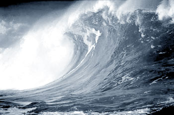
Experts' view is that these tsunami waves moved rapidly in the deep ocean reaching up to 1000 kilometers per hour with little loss of energy. In the deep sea these waves generally go undetected. Speed of the waves gets reduced as it reaches the continental shelf and the coast whereas the wave height and the thrust on the shores get increased. If the trough of the tsunami waves (negative waves) reaches the coast first it causes a phenomenon referred to as drawdown which is soon followed by a run up that brings a massive block of water. In fact these phenomena were observed at the occurrence of the tsunami on 26th December 2004. These Tsunami waves can travel great distances from the point of occurrence. In 1960 a tsunami triggered off by an undersea earthquake in Chile hit the coast of Japan 14 hours after the occurrence of the earthquake Chile. Tsunami of 26th December 2004 travelled a distance of 1500km and took 2 hours to reach the coasts of Sri Lanka. Views have been expressed by Geoscientists and Seismologists that Tsunami of 26th December 2004 was caused by a collision of two of the earth's tectonic plates causing one plate to sink below the other namely collision of Indian plate and Myanmar plate whereby the Myanmar plate moved 15 feet over the Indian plate. This caused a rupture of more than 1200 kilometers and width of over 100 kilometers. The focus was at a depth of about 10 kilometers from the earth's surface. The epicentre of the earthquake was located on the sea bed of the west coast to the south east of Banda Ache in Northern Sumatra. Much of the slip was 400 kilometers to the south west of the rupture. It is now agreed that this earthquake recorded a magnitude of 9.3 on Richter scale. Scientists have observed that the magnitude of this earthquake was such that it has caused the planet to spin 3 Micro Seconds or a millionth of a second faster and tilt about an inch on its axis (According to NASA Geophysicists Jet Propulsion Laboratory in California). Tsunami identificationThe scientists are agreed that earthquakes cannot be predicted. Hence scientists cannot determine exactly when a tsunami will be generated. The mechanism installed to identify tsunami is a complicated one. Such mechanism comprises broad band seismic station, tide gauges, pressure sensors placed at the sea bottom, buoys placed on the sea surface, satellite connections etc. Since the Pacific nations have been the most affected and vulnerable region to tsunamis, scientific studies relating to tsunamis have been confined to the Pacific Ocean region. Pacific Tsunami Warning Centre is located at Honolulu and is connected to United States Geological Survey in California. This mechanism caters mainly to the Pacific Nations. Present scenarioIn recent times certain developments have been discovered after scientific research made by geophysicists and other geoscientists. It was believed that Sri Lanka is a relatively safe area for tectonic disturbances such as earthquakes as it lies thousands of kilometers away from the earthquake vulnerable areas in the Indina Ocean, namely Subduction Zone of Sunda Strait in Sumatra. Nevertheless in view of the studies carried out by James Cohoran and his team of experts at Lamont Doberty Earth Observatory relating to the development of a new plate boundary Sri Lanka is no more a safe zone for tectonic disturbances. These discoveries refer to a splitting in the Indo-Australian plate just 350 km south of Sri Lanka. This zone of splitting has brought into being a "diffuse zone" separating Indo-Australian plate, Indian plate to the north and the Australian plate to the south. Western part of the zone shows signs of divergence whereas the Eastern part shows signs of convergence and further he observed that this 13th plate boundary is linked up to the seduction zone of the Sunda Strait and as such some of the pressure accumulated to the focus of 26th December 2004 earthquake would have been released to the diffuse zone of the 13th plate boundary. According to Prof. Dissanayake of the Geological Department, Peradeniya University the narrowest point between the eastern and western boundaries lies to the South of Sri Lanka. So his observation is that Sri Lanka is at the doorstep of a hyperactive plate boundary. Therefore, vulnerability of Sri Lanka to earth tremors and earthquakes is greater. Another pertinent observation made by geophysicists is that the Indian plate which is moving northwards faces resistance from the Himalayas. It is in fact 'crashing against' Himalayas and the Indian geophysicists have given a warning of an imminent earthquake in Indina sub-continent. Undoubtedly, if such an earthquake occurs in the Indian Sub-continent it could have some consequences in Sri Lanka as well. Sri Lanka, not being far away from the recently formed hyperactive plate boundary referred to above, steps will have to be taken to have vigilance over the hydro power reservoir dams. In this regard special reference has been made to Kotmale project that in the event of a dam breaking, whole of Kotmale, Peradeniya and part of Kandy would be inundated. Post-tsunami research conducted by John McCloskey of the University of Ulster has revealed that the magnitude of 9.3 Richter scale earthquake of 26th December 2004 near Banda Ache had dramatically increased stress on the Sumatra and Sunda Trench fault and as such is ready to deliver another major earthquake. The earthquake is predicted to reach a magnitude of 8 to 8.5 Richter scale and its location 200 kilometers from the Sumatra Coast. One cannot forget that scientists did warn the occurrence of 28th March 2005 earthquake. The scientists have emphasized the need to have a regional tsunami warning system for the Indian Ocean. Height and Inundation distanceAccording to a survey conducted by Dr. Janaka J. Wijetunge, Senior Lecturer, Department of Engineering, University of Peradeniya it is revealed that the average heights of tsunami waves of 26th December 2004 in the east coast were 5 meters. Certain places waves had reached heights of 7.5 meters. In the southern coast average height had been 5 meters but areas in Kirinda and Yala and some stretches of Galle, the Tsunami had reached heights varying from 10 to 11 meters. Owing to factors such as bathymetry of the coastline topography and geological setting of the continental shelf and eco systems the impact of the waves on the beach and distances waves travelled showed a variation. The water line at the beach travelled several hundred meters inland as a wall of water with great destructive power inundating low lying coastal areas causing considerable loss of lives and property - Early warning mechanismFour seismic network station had been installed in Sri Lanka namely. 1. University of Peradeniya, University of Rajarata, University of Ruhuna and 4. South Eastern University (Oluvil) Equipment installation in each station comprises a short period seismometer, force balance servo accelerometer, data logger and computer system for Data correction; and analysis. Co-ordination work amongst the seismic net work stations too had been established. Peradeniya Seismic Net Work which was the nerve centre is connected to the other stations via telephone. Processing of data is to be done at Peradeniya. By 17th May 2003, installation procedure had been completed. Nevertheless it is unfortunate that Peradeniya Seismic Station was not functioning on the 26th December 2004. At the Peradeniya Station, the broad band seismometer functioned only for a period of 3 months and the short band seismometer only till July 2003. This had been due to failure in the computer network. SystemMain purpose of setting up the aforesaid seismic network is purely academic, in order to enable training of University students on how seismic data are collected, processed and analysed. According to Dr. Ranjith Premalal de Silva, this equipment set up is much more sophisticated and powerful that the equipment installed at Pallekelle. He also expressed the views that since the three stations linked to Peradeniya are stations within the island itself not far from Peradeniya, it will not be effective to detect and identify earthquakes occurring outside Sri Lanka. Since the Peradeniya Seismic NetWork which is considered to be the nerve centre is linked up with three other seismic equipments set up at the Universities of Rajarata, Ruhuna and Oluvil, each of these stations functioning 24 hours, and the telephone dial up link operating effectively, it can detect and identify earthquakes, tremors and any other seismic events occurring within the island as well as outside the island for an area of 300km. Further in view of the thinking of the experts in geology and other earth sciences that there is a possibility of localised minor earthquakes, tremors and other seismic events in and around reservoirs and highland landslide prone areas it is incumbent upon the authorities to repair and maintain this vital seismic network system and bring back the system into operation. In these circumstances it is necessary to upgrade the seismic network at Peradeniya along with the three other seismic network stations installed at Ruhuna, Rajarata, and South Eastern Universities which are linked to Peradeniya system via telephone line. Once it is upgraded the Peradeniya seismic station, which is the nerve centre could, after checking and processing the seismic data, calculate the magnitude, detect and identify the earthquakes, tremors and other seismic events occurring within the island and outside Sri Lanka upto a distance of about 300km. Following additional steps if taken, would be meaningful. (1) To link up Peradeniya seismic station with Geological Survey and Mines Bureau which has a seismic station at Pallekele, Kandy set up for the purpose of providing continuous geophysical observations of global and regional earthquake activity. This should enable the Peradeniya seismic station to have access to have seismic recordings and data coming from other stations outside Sri Lanka through Pallekelle seismic centre and would thereby be in a position to warn people of an impending tsunami through the mechanism set up for that purpose. (2) To link Peradeniya network system with the Meteorology Department which has already set up a satellite link with the Pacific Tsunami Warning System as well as Japanese Meteorological Agency. These steps are necessary in view of the following factors: (1) Possibility of experiencing earthquakes, tremors and other seismic events associated with the 13th plate boundary just 350km. to the south of Sri Lanka in the Indian Ocean. (ii) The fact that the Indian seismologists forecast the happening of an earthquake in the near future in the Indian sub-continent, as a result of the Indian plate "crashing" into the Himalayas, there is a possibility that Sri Lanka also would face repercussions. (iii) Strong possibility of occurrence of large earthquakes on the segments to south of 1200km. meter fault of Banda Ache-Sumatra earthquake of 26th December 2004, as was evidenced by the earthquakes of 28th March 2005 and 12th September 2007. (iv) Possibility of occurrence of minor earthquakes and earth tremors at the reservoir areas which would result in dam breaking and the possibility of landslides and minor earthquakes in the hill country area. Pallekelle stationConsequent upon an agreement signed between the Geological Survey & Mines Bureau of Sri Lanka and the Institute of geophysics, Planetary Physics of the University of California, San Diego-Project IDA, 120 Digital Broad Band three components seismic Station has been established at Pallekele. According to the agreement the purpose of this installation has been to provide continuous geophysical observations of global and regional earthquake activity. It was intended that the station continue operation indefinitely. The seismic waves and related data picked up at Pallekelle station are recorded in the magnetic tape and transmitted automatically via telemetric means to the station at the University of California, San Diego. Wave patterns picked up at Pallekele is shown in a visual form by a graph. Even though this graph would indicate the happening of a seismic event it is not possible to get at the magnitude or the location of an earthquake. Once unprocessed data goes to the University of California San Diego the processing is sometimes done there itself or transmitted to U.S. Geological Survey (USGS) where all data coming from other global stations would be available for processing and analysis. This procedure followed at San Diego University would detect the magnitude and the location of an earthquake. SuggestionsThe station at Pallekelle on its own cannot identify the magnitude or the location of an earthquake. Hence as suggested by experts it is necessary to have a processing unit analysing facilities at Pallekele which should be connected up with least two other stations in the Indian Ocean region. This has to be done in collaboration with the University of California in San Diego who is the other party to the agreement arrived at between Geological Survey & Mines Bureau and University of California, San Diego. This system could be linked up with the Seismographic station at the Universities of Ruhuna, Rajarata and Oluvil. Further there has been a suggestion that Pallekelle station should be connected to the major reservoir dams. To achieve the micro seismometers should be installed at the base and the surface of the major dams. This would help to give early warning relating to any possibility of dam breaking which would create a catastrophic situation in the reservoir areas due to seismic activity. On 26th December 2004 we in Sri Lanka did not have any mechanism to get an early warning of an incoming tsunami. Neither did we have any link with the Pacific Warning Tsunami Centre nor the Japanese Meteorological Agency. This could be explained because Sri Lanka did not anticipate a tsunami for the traditional belief was that Sri Lanka is a safe area relating to earthquakes. According to Dr. Weinstein that on 26th December 2004, the Pacific Tsunami Warning System at Honolulu did not have any telephone numbers or E-mail numbers to give a warning to Sri Lanka. Sri Lanka and warning systemThe following information is required to issue an early warning to the people namely, time of origin, location, magnitude and depth of the earthquake and tidal data giving sea level rise. The mechanism to obtain the above data comprises a network of seismic stations to observe seismic waves, tidal stations comprising buoys and pressure sensors in order to transmit sea level changes via satellite, data processing and evolution station with qualified seismologists and other scientists and dedicated telephone line to give warning to the people. The costs involved in such an endeavour would be enormous and the national budget would not be able to bear up such huge financial commitments. But it appears from post tsunami developments that National Co-ordination Group for Tsunami Warning System in the Pacific (ICG/ITSU) is promoting coordination and co-operation to set up a permanent regional warning centre in the Indian Ocean. Until then Pacific Tsunami Warning Centre and Japanese Meteorological Agency will co-operate by providing interim warning services to the Indian Ocean region. In the circumstances it is imperative that Sri Lanka should have a mechanism to establish such a link with Pacific Tsunami Warning Centre in Honolulu and Japanese Meteorological Agency via satellite and dedicated telephone lines. Therefore, in view of these developments Sri Lanka need not panic and worry about as to how a country should receive an early warning in the event a tsunamigenic earthquake generated a tsunami. In respect of 2nd September 2007 earthquake the Metrological Department was able to issue a warning well on time even though the earthquake did not trigger off a tsunami. The writer is the Deputy Director Sri Lanka Judges Institute, Member of the Tsunami Commission which inquired in to natural disasters in Sri Lanka, and a former Judge of the Court of Appeal, |
|