Beautiful spaces in Sri Lanka:Mannar island
by Husna Inayathullah
 |
|
Donkeys of Mannar |
The Mannar island occupies an area of 1505.4 square kilometres. It
has been known historically by names such as Manthei, Mathota,
Mahathiththa, Mahaputu and Mawatuthota. Mannar has a dry desert climate.
There are two main roads leading to Mannar. One is the road passing
through Anuradhapura and Madawachchiya along which 80km should be
travelled to reach Mannar. The other is the recently opened road through
Puttalam, Eluankulam, Silawatura and the Wilpattu National Park. Today
we enlighten you about a few of the attractions which include fauna,
flora and strategic places of the island.
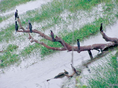
The Venkalai bridge connecting the Mannar Island is the longest
bridge built in Sri Lanka. The bird-sanctuary is located on either side
of the bridge between Paliyanthiv and Thirikenilwert. It is 4828
hectares in extent. This place which is a sanctuary of migratory birds
is a retreat for about 200 types of birds. Siyakkaraya, Kabiliththa,
Ranpath tharawa, Ulpeda Tharawa and Petamathabatta are the main types.
Apart from them very rare species of animals have made this place their
home. They are the Geta Kibula and Muhudu oora.Mangrove plans and
stretches of sand are found all over the Venkalai Sanctuary.
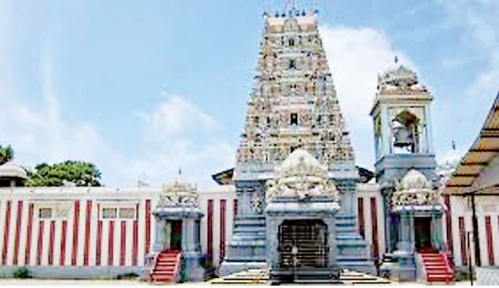
Thiruketheeswaram Kovil is one of the famous Kovils built to worship
God Eeswara.
This Kovil is situated near the A-32 road. There is a legend that the
Kovil was built by Mayan, Ravana's uncle. It is also believed that Rama
had worshipped at this temple before travelling to India with Seetha.
Another belief among the villagers is that a Brahmin of King Vijaya had
worshipped at the temple. The temple is one of the legendary sites where
Eeswara had performed many miracles.
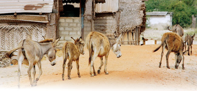
Donkeys had been imported to Mannar from Somalia for draft purposes.
These donkeys were transported to Puttalam and Kalpitiya too. They can
still be seen in herds in the streets of Mannar.
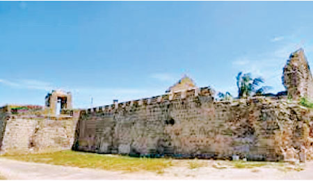
The Mannar Fort had been built by the Portuguese. After 1696 the Fort
has been controlled by the Dutch. The English captured the fort on
October 5, 1975.
The Mannar port could be described as one that linked Sri Lanka to
the world. There are details about the Mannar port and fort in a stone
inscription at Thamanhil island.
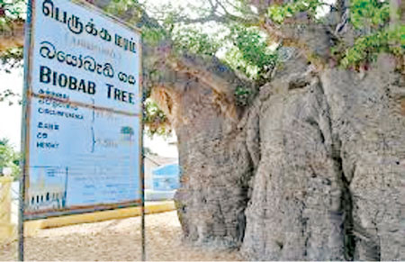
The Biobab is a huge tree found on the Mannar island. The largest
Biobab tree in Mannar is found about 2km from the entrance to Mannar
island.The Biobab tree had been the favorite food of Camels brought to
the island for draft purposes.
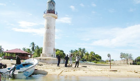
A beautiful beach called Urumale is situated on the Mannar island.
The light of the light-house situated in Rameshwaram, India could be
seen at Urumale beach. The only place in Sri Lanka from which another
country could be seen is the Urumale beach. The closest beach to India
is the Urumale beach. The sand-hills of the Adam's bridge which the
legendary Hanumatha had used are seen at Urumale. A variety of fish are
present in this sea-strip. Beautiful corals are also seen.
Adam's bridge is also known as Rama's bridge or Rama Setu. This is a
chain of limestone shoals between Pamban Island, off Southeastern coast
of Tamil Nadu and the Mannar Island. According to geologists, this was a
former land connection between India and Sri Lanka.
The bridge is 30km long and is believed to have been a continuous
structure during the olden days. However now it is separated into 18
parts.The Sri Lankan Navy governs nine of them and other nine belongs to
the Indian Navy.
The bridge separates the Gulf of Mannar from the Palk Strait. Some of
these sandbanks are dry and the sea around them is very shallow. It is
said that during the bygone days people reached India on foot along the
bridge. First mention of the bridge is in the ancient Sanskrit epic,
Ramayana of Valmiki. The Navy conducts boat trips every day. The boat
trip is 15 km from the mainland to the sea. People can walk on the sand
bank and spend their time. |


")


