New
plan to over Kandy’s traffic nightmare
Fees to control street parking:
Expanded pedestrian areas:
Decentralised bus terminals:
 Improving the capacity of city entry corridors and intersections and better
regulating school transport are among the short-term measures proposed by
transport researchers to ease traffic congestion in Kandy, the country’s
second-busiest city, where vehicle speeds are as low as 4-15 kmph on busier
roads. Improving the capacity of city entry corridors and intersections and better
regulating school transport are among the short-term measures proposed by
transport researchers to ease traffic congestion in Kandy, the country’s
second-busiest city, where vehicle speeds are as low as 4-15 kmph on busier
roads.
Such low speeds in the transportation network leads to lower economic
productivity in the city, and to negative social and environmental consequences,
according to studies done by the Moratuwa and Peradeniya universities, Road
Development Authority and Ministry of Urban Development. Kandy, with a
population density of around 2,500 persons per square kilometre, has
topographical features which restrict road widening and new roads.
Short-term solutions
Promoting off-street parking while regulating on-street parking through a
pricing policy and improving pedestrian facilities have been identified as
short-term solutions to increase transport network speed, according to the
research. Its main features were presented at the R4TLI - Research for Transport
and Logistics – conference on research for transport and logistics industry
organised by the Sri Lanka Society for Transport and Logistics with the
Chartered Institute of Logistics and Transport, Sri Lanka.
The research paper, ‘Strategic Interventions for Improving Transportation in
Kandy City’ was awarded the best research paper in transport planning at the
R4TLI. The authors were Prof. Amal S. Kumarage and Janaka Weerawardana of the
University of Moratuwa, and I. M. S. Sathyaprasad of the University of
Peradeniya.
The strategy outlines how a sustainable transport system could be achieved. The
research recommends that 60% of the people arriving in the city should use
public transport and as such recommends the improvement of the bus and railway
system, said Prof. Kumarage.
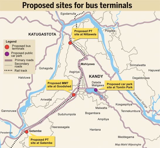
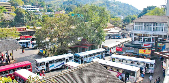
This includes creating a multi-modal transport hub in Kandy and improving bus
operations which currently causes severe congestion in the city centre due to
over 5,000 buses terminating in Kandy.
Traffic counts conducted at each of the entry points to the Kandy Municipal Area
(KMA), covering about 12 square kilometres, and the core Central Business
District (CBD), of around three square km, showed 318,000 passengers entering
the KMA in 56,000 vehicles on a daily basis.
Private vehicles make up 79% of the vehicle flow but carry only 32% of the
passengers while route buses make up 9% of Average Daily Traffic but carry 64%
of passengers. Rail carries about 3,000 passengers to the city every day: a mere
1% of the total number arriving.
 The findings of the studies show the main causes for an inefficient transport
system in Kandy: limited road infrastructure, conflicting land use and poor
orientation of bus routing, terminals and stops. Also identified were inadequate
by-pass roads for KMA and CBD, inappropriate traffic circulation and parking
demand management measures, under-utilisation of the railway network, and lack
of management of para-transit modes such as school vans and trishaws.
Inefficiency of the transport system also led to increased social and
environmental issues such as air, water and noise pollution. The findings of the studies show the main causes for an inefficient transport
system in Kandy: limited road infrastructure, conflicting land use and poor
orientation of bus routing, terminals and stops. Also identified were inadequate
by-pass roads for KMA and CBD, inappropriate traffic circulation and parking
demand management measures, under-utilisation of the railway network, and lack
of management of para-transit modes such as school vans and trishaws.
Inefficiency of the transport system also led to increased social and
environmental issues such as air, water and noise pollution.
Relocation
Based on research, a new transport demand management plan was developed to
address the issues identified, while also taking into consideration design
limitations. A physical infrastructure development plan has been prepared to
support the transport demand management plan. These two plans were merged to
make an Integrated Development Plan covering the overall land-use, traffic
management and physical infrastructure changes.
“It recommends the long-term relocation of wholesale and other activities that
are not aligned to the core attractions of the city to peripheral satellites
such as Peradeniya/Katugastota and Tennekumbura where transfer transport
terminals are also recommended,” Prof. Kumarage said.
Kandy City should be a ‘traffic restrained’ area given its cultural context as a
Heritage City, its population density, as well as its geographical and
environmental setting, according to the study.
Reallocating land-use inside the city and setting up three satellite cities at
Peradeniya/Gatambe, Katugastota and Tennekumbura were key long-term
recommendations to eliminate unnecessary vehicle movements inside the city.
The road space within the city is recommended to be transformed into pedestrian
use to ensure they are able to spend more time in the city, the professor said.
“Haphazard parking has been identified as poor use of the existing limited road
space. Several parking locations have been identified while a parking policy
that discourages on street parking has been proposed.”
The study also recommends the double tracking of the railway between Peradeniya
and Katugastota as the current mode share of commuters is only 1%. It identified
that 23% of the traffic could by-pass the city if alternate roads are available
and recommends a network of roads to be developed including the possibility of a
tunnel to connect the eastern access to the southern access. Re-routing bus
services, integration of bus terminals and railway station, introduction of new
railway commuter services are recommended as medium-term interventions to
facilitate through-trips while reducing pedestrian movements in the city core.
|