|
Norway gives earthslip prevention hi-tech :
Our hills are ready to slide!
by Rukshana Rizwie
The 'Pearl of the Indian Ocean', our island home might be but, at the
same time, the earth under our feet, no longer firm, according to
natural disaster experts. Sri Lanka ranks high on the list of landslide
and flood risk in the world. Worse, we also rank high among those
countries lacking disaster mitigation capabilities.
 |
|
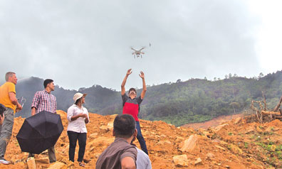
Norwegian researchers
conduct a field study using drone technology. |
According to researchers at the University of Stuttgart, who have
released the World Risk Index for 2016, Sri Lanka risks becoming a
victim of a major disaster as a result of natural hazards such as,
floods, cyclones, or landslides compared to the other countries in the
Asian region.The World Risk Index 2016 ranks 171 countries according to
how exposed and vulnerable they are, to natural hazards, including
earthquakes, floods and storms. The index refers to the percentage of
population living within reach of potential hazards, and, vulnerability
to suffer harm when being hit the hardest. A country's specific risk is
determined by multiplying its exposure by its vulnerability. Risk is at
its highest where a high level of exposure to natural hazards coincides
with very vulnerable societies. Poor economic and social factors also
leave countries less able to keep their populations safe, the
researchers said. According to the Index, Sri Lanka stands at 63rd rank
with a risk index of 7.32 indicating a high level of risk including
exposure to potential natural disasters.
The susceptibility was at 24.1% while vulnerability was 49.2%, and
lack of coping capabilities at an alarming 78.08%.
Subsidence prone
Disaster preparedness and risk reduction are factors that the
National Building Research Organization (NBRO) has been looking into,
with the help of experts from the Norwegian Geotechnical Institute.
The project, sponsored by the Royal Norwegian Embassy looks at a
technical co-operation between the two stakeholders.
One of the early findings of the project was geotechnical
investigations in Matale which revealed that there was a substantial
area that was subsidence prone. Rajinder Kumar Bhasin, Regional Manager
for Asia told the Sunday Observer, their findings showed there was a
risk of sink holes at a particular point which was thoroughly studied
through several images taken from a German Satellite and Field
Investigations conducted by the NBRO. "The NBRO which visited the police
station in the area found that some of the walls had visible cracks to
denote that, the ground was in fact weak and unstable."
He explained that the remote sensing and mapping of the geographical
area was done through Synthetic Aperture Radar (SAR) by the Geological
Survey of Norway (NGU). NGU used a range of remote sensing, dating and
geophysical techniques, as well as advanced digital methods and
classification systems, to map the specific area.
Drones
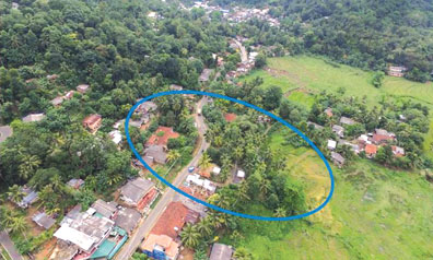 |
|
An aerial view of a
landslide prone area in Matale. |
Consequently a subsidence map was prepared by the NBRO which proved
the researchers' findings.
The map shows several highly hazardous areas. Through the use of GPR,
the officials were able to pinpoint locations of a possible subsidence
in land mass.
The researchers who were in Sri Lanka surveyed the extent of the
landslides at Aranayake and Meeriyabedda through the use of aerial
observation drone technology. "We also gave the NBRO a high end
computing machine which will process the data that the drone gathers,"
said Helge Smebye, a senior engineer at NGI.
"We hope this type of advanced and new technologies will help to be
better prepared and know beforehand, areas that are of high risk and
devise strategies for possible evacuation before a disaster strikes."
"We found that the area still had a lot of tension, cracks, loose
soil, erosion and loose boulders which indicate they are still
vulnerable to a possible landslide," said Bhasin, adding that this new
information will assist officials planning to resettle villagers in the
same vicinity. He said, however, the area where people are now resettled
was stable and safe. The researchers who also visited the Meriyabbeda
site said, they were surprised to find thick vegetation even after a
landslide.
However, they found a pattern in the cracks which they say is
potentially dangerous.
They said, none of the research findings would have been possible if
not for the use of the drone technology to map out the area.
The team of researchers has already progressed to the second phase of
the project and will be exploring ways and means of reducing disaster
risk. The second phase of the project will last one year and has
received a funding of NOK 3,000,000.
"We are going to build a team comprising officials from the NBRO as
well as experts and researchers who will look into the existing early
warning system to upgrade it," said Smebye. He added that the NGI has
already given the NBRO several rain gauges.
|