The Kinduru of the Jataka stories?
by S.B. Karalliyadda
Our heroic soldiers are now engaged in the last lap of the separatist
war in Mannar and some parts of Jaffna. Mannar is a place related to our
island country from ancient times even before our chronicle Mahavansa
was written. It was Mannar from where Hanuman the monkey worrier
mentioned in Ramayana arrived in Lanka with his troops.
Hanuman built a bridge to cross the Mannar gulf from Rameswaran. This
incident is supposed to have occurred during the rule of Rawana more
than two thousand years before the arrival of Vijaya B.C. 544 from which
date our history is recorded in Mahavansa.
|
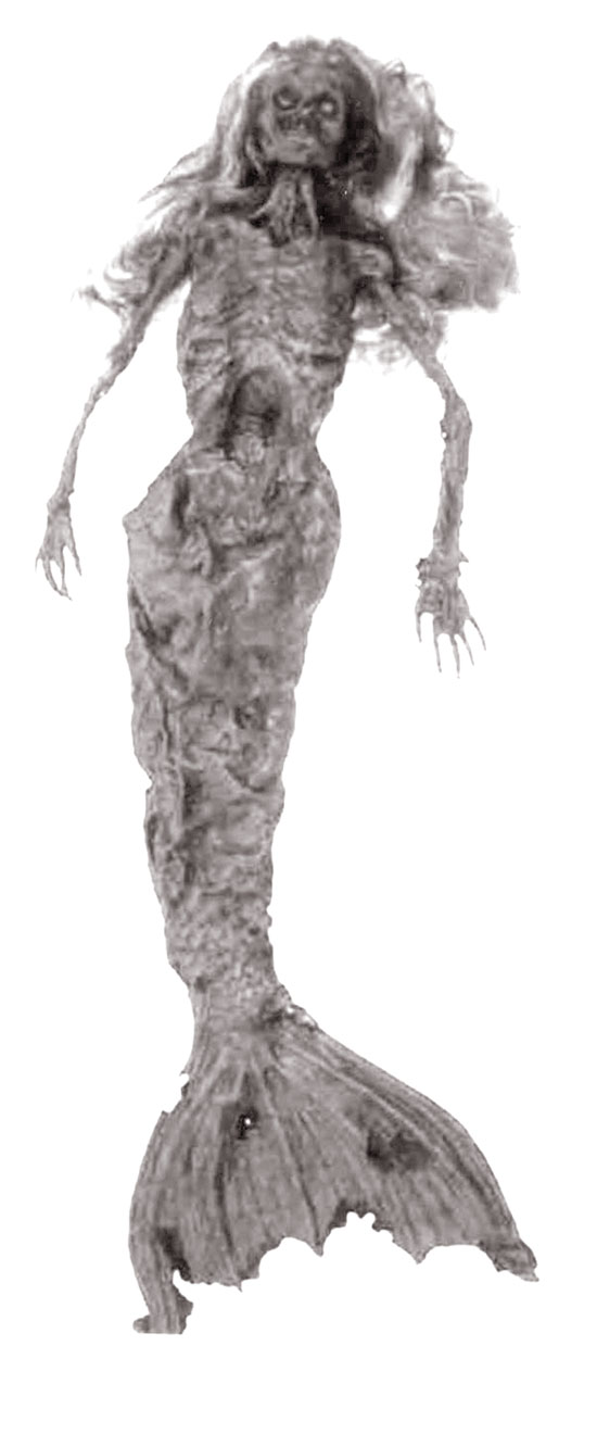
Are these the fish named in Buddhist Jataka stories as
KInduru? |
The bridge built by Hanuman is known as Adams Bridge which is sunk
to-day in the deep sea as shown by the ocean scientists. The Indian
Archaeologists filed action in the Indian Supreme Courts against the
Rama - Sethu Samudran project and brought to the notice of the courts
about the damage that will be caused by the Sethu Samudra proposed new
sea route to the portions of the Adams bridge now sunk in the deep sea.
The Archaeologists wanted this bridge now under water to be preserved
as a cultural heritage. Vijaya sailed through Kadamba nadi now
identified as Malwatu-oya and landed in Aravi aru which is Arippu as
known to-day.
The area was a transit centre of the Indo-ariyans. The principal sea
port Mahatitta or Mantai is located in the land area opposite the modern
Mannar town. This seaport was known in Sinhala as Mahavoti, Mahapatu,
Mahauthee, Mawathupatuna, Mahapatuna, Matota etc;, while the Tamils call
it Manthive now.
The Pandyan princess who was brought here as Vijaya’s queen also
landed here from this port. The land area is buried under the sea and in
the rock is located Thiruketheeswaram Hindu temple.
It is recorded that this was an International sea port where traders
from Perisa, Egypt, China, Arab and other Far Eastern countries met.
They traded in pearls, oyster, elephant tusks etc.
These traders have recorded that there were large fish here similar
in appearance to humans. Their heads could be observed as human heads
from above water level.
They milk their off springs and disappear under the water when
disturbed raising their posterior which resembles a fish tail. They were
mammals. This kind of fish was observed from the Mannar sea coast up to
Kalpitiya by Emerson Tennent. The Greeks named them “Dugong”.
They were more than seven feet in length. The Europeans named them as
“mermaids.” Are these the fish named in Buddhist stories as “Kinduru”.
The fish caught in Mannar and sent to Colombo in 1874 was more than
seven feet in length.
|
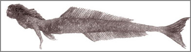
Fish similar in appearance to humans |
In 1560 seven of such fish were caught and sent to the Viceroy who
was in Goa. The Viceroy’s Surgeon Demas Bosque dissected these fish and
reported that they are similar to humans in their anatomy and their
flesh tastes the eel fish (see the Google photographs).
A skeleton is now found in the Natural History Museum Belfast. In the
period of Sri Megavanna (301-328) there had been a Kovil and in the
ninth and tenth centuries the slaughter of cattle in Mannar area was
prohibited according to Prof. Senerath Paranavitana.
This shows that the Buddhist and Hindus who lived in harmony attended
their religious ceremonies together. Epigraphica Ceylonica Chap i page
245. Chap ii page 235, Chap iii pages 133, 135, 225 records that the
Sinhala king engaged the services of his officials to collect taxes from
the area.
The proximity of Mannar to South India was the reason for frequent
attacks by Cholas and Pandyans. Elara in the second century landed here
from this sea port.
Elara’s General Bhalluka too arrived from Mannar. When the Lambakarna
king Ealanaga (33-43) was banished from the Island by his own relations
the king fled to Kerala from this port.
The Gulf of Mannar was famous for pearl fishery and the British were
engaged in pearl fishery in commercial scale. Lord Guilford built a
circuit bungalow “Doris” for the Governor to lodge during pearl fishery.
Mannar area is rich in other resources.
Battles in the past
Pallawa kings Narasingha Raman I and II sent Mallawa troops against
prince Manawamma but they were defeated in the Mannar battle field. In
the reign of Aggabodhi II (772-277) a Pandyan troop arrived from Mannar
to conquer Lanka but prince Mahinda who was in-charge of Mannar defeated
these troops in the Mannar area itself.
In the eleventh and thirteenth centuries during the long Chola and
Pandiyan invasions Mannar then Mahatitta was the port that the alien
troops used to land in Sri Lanka. Prof. Senarath Paranavitana states
that due to the proximity of Mahatitta to South India the Tamils
frequently migrated to this area and settled down and Tamilised the
place names in the area. King Vasaba (67-111) built the Kohala alias
Kehala tank in the area. At that time this area was known as Uttaradesh
alias Uttararata.
The tank built by king Dhatusena (455-473) then known as Mahamattaka
is the giant tank today. Maha Parakramabahu waged a war in this region
and annexed this area to Uttasara or Uttararata.
He built a fortrees in a place then known as Pilawasu. Later in 1560
the Portugese built a fortress and the Dutch in 1458 chased the
Portuguese and fortified the fortress. Mulaitivu was a fortress of the
Portuguese Dutch and the English. At a later period in the Kandyan war
in 1803 Major Davy Commanded the troops from here but the Kandyan war
heroes were able to get back the port to the Kandyan kingdom.
The re-patriation of stateless Indian labour under the Sirima-Shastri
pact was through Talaimannar to Danuskodi and Rameswaran. In the good
old days we used to utilize the free railway warrants to travel to
Talaimannar. The government Rest House that we used to stay is occupied
by the Army today.
Jaffna area which belonged to the ancient Pihitirata was an area with
four lakhs and fifty thousand villages. It is the land area beyond
Elephant Pass inclusive of the peninsular. The area is flat land without
any river or perennial water resources. Iranamadu is the ancient tank
here.
The Naga tribe that lived here during the time of the Buddha were
related to the Nagas of Kelaniya. The Buddha visited Nagadeepa to settle
a dispute that arose between these tribes. The village where this war
was to take place was known as Malalagama which is Tamilised Mallakm
today.
The Buddha demarcated a sacred area here and a bo-sapling was
planted. It was known as Rajayatana then. King Bhatikatissa (143-167)
built a guard house and a Vihara named Rajayathana Dhatu Viharaya. King
Agbo II (571-604) built a monastery and a outer cover to the Amala
Vehera in this place.
The delegation of king Devanampiyatissa set sail to meet king
Dharmasoka from the port Jambukola. It has taken eleven days for this
journey and fourteen days for their return.
The tooth relics were brought here through this port. This port is
Tamilised as Sambilthurai today. It is located near Kankasanthurai. The
delegation that brought the Sri Maha-bo sapling also arrived through
this port. King Devanampiyatissa built the Samudda Viharaya here and
planted a bo sapling. This Vihara was also known as Valika Viharaya.
The Situ, clan who accompanied the Bodiya were settled in
Sittukulampattuwa. Vijayabahu I (1055-1110) restored the Valika Vihara.
King Devananpiyatissa has built a vihara here by the name of Tissamaha
Viharaya.
The “Vallipura stone Inscription” of King Vasaba (67-111) states that
this area consisted of a vast Sinhala population. This inscription was
near Pt. Pedro. Piyangutissa a Minister of Vasaba built a Viharaya in
Vallipura. Piyangudeepa the area where Piyangutissa overlooked is
identified as the modern Punkudutivu.
There had been twelve thousand Buddhist priests living in this area.
The King’s Prime Minister Isagiri was in-charge of Nagadeepa. The
modern Kyts Islands close to Nagadeepa was then known as Karadeepa or
Abideepa. There were other Viharayas such as Madana, Kolase and the
Salipabbata Viharaya in Nagadeepa built by Vahallakanaga.
This area was subjected to frequent attacks by Cholas and Pandyans.
Due to the famine that lasted for nearly two and a half decades after
the Pandyan invasion in 1283 the Sinhala population migrated to the
South of the country. There were many principal sea ports in the area.
They are Uratota which is Keyts to-day, Jambukola which is
Sambalthurai now, Piyangndeepa which is Punkudutivu etc. Several Sinhala
names such as Valigomuwa which is Valikaman now, Hunugama now Chunnakam,
Malalagama now Mallakam, Jawa Kotte now Chavakacheri, Karadivu now Keyts,
Kadurugama now Kandador Kodigama now Kodikaman etc: are Tamilised today.
De Quevroz the Portuges historian records that the area was under the
Kotte king when the Portuguese first landed in Sri Lanka. In 1658 when
the Dutch invaded the area belonged to King Wimaladharmasuria I of
Senkadagala.
Sir Samuel Baker records that when the area was constantly under Arab
merchants attack, the Tamils in the area were protected by the
Sinhalese. The area which was under the Portuguese and Dutch for
sometime was annexed to the Kandyan kingdom by Rajasingha II.
The Dutch captured the Kings pet tusker “Horatala” and the King found
it difficult to enlist fighters to wage wars. Therefore the King by an
special order issued on 09-04-1660 declared a pardon to the prisoners if
they join the war.
Ferguson the government Surveyor states that the area had a
population of two lakhs and twenty thousand in the eighteenth century.
“Kailasa Mala” a book of poems describes how the Nagas of the peninsular
were chased and area occupied by the Tamils.
This is in short what the poem says. A princess born in Tanjore had
the head of a horse. She was advised to bathe in a well at Keeramalai if
she was to get a head of a human. She bathed in the Keeramalai well and
got a human head as predicted. This incident is commemorated up to
to-date annually in the Mahavittipuram Kovil built in memory of this
event.
A minister who accompanied this princess has gone to the area of the
Sinhala king. This ministers name was Yalpanam alias Yalpanando. The
King gave this area to the minister to-be in-charge and named the area
as Yalpanam. The Europeans who arrived in the area later named this area
as Jaffna or Jaffnapatam. After this a royal clan of Nallur was found
who later on ruled the area including Vanni and Mannar.
In 1617 the area came under the Portuguese and in 1658 under the
Dutch. Our sandesa poems narrate that Jaffna was annexed to Kotte
kingdom by Sapumal Kumaraya who became the king of Kotte as Buwaneka
Bahu VI (1464-1471). King Senerath in 1628 invaded Jaffna with his two
step sons Vijayapala and Kumarasingha. When the Kandyan convention was
signed on 02.03.1815 Jaffna was a part of the Kandyan kingdom.
In the periods of nineteen sixties Jaffna had a flourishing
agricultural economy. Up country vegetables such as cabbage, carrot,
leeks, tomato, beans, potato were grown there. Tobacco was a subsidiary
crop. The Colombo markets were full of grapes, mangoes and varieties of
fruits grown in Jaffna.
There was a strong chain of Young Farmers clubs, Co-op societies,
Transport Societies of Lorry owners, Famer organisations etc; with whom
I had strong links when I worked as a public servant in the area.
The then government launched a WHO/FAO/UNICEF assisted Agricultural
Extension and Applied Nutrition Programme in the peninsular for the
benefit of local famers and housewives. It was the golden Era of the
Jaffna farmer. This was a period from 1965-70 when the Minister of
Agriculture was late Mr. M. D. Banda in the Dudly Senanayake Cabinet. |