China�s Danxia landform
It sure seems as if the invisible artists of Mother Nature have had a
field day painting the landscape in different hues of red to match the
glorious rays of the Sun in southeast and southwest China.
The entire terrain classified as the Danxia landform by the
scientists due to the topography of the area really looks like a painted
picture with its tiers of red rocks and cliffs, like Danxia (red rays of
the sun).Many have compared it to a ruby sculpture park and it is in
fact known as China�s Red stone Park.
The Danxia landforms is named after Mount Danxia, one of the most
famous examples of the Danxia landform, located in Renhua County of
Guangdong Province. It was early in the 1930s,that the late geologist
and member of the Chinese Academy of Sciences, Professor Chenguoda,
named this kind of topography of which Danxia Mountain had the most
classic features as Danxia landform, after a thorough study of the red
stone mountain regions.In 2010, several Danxia landscapes in southern
China, with a general name of �China Danxia�, were inscribed as a World
Heritage Site.
The total core area of the six regions above is 73945 ha, and the
total buffer area is 65446 ha.Over the past 70 years, China�s geologists
and geographers have identified 715 Danxia landforms in China. Danxia
geomorphology has developed into a sub-discipline of geomorphology and
Danxia Mountain has become China�s research base for Danxia landform
which has vibrant colours.
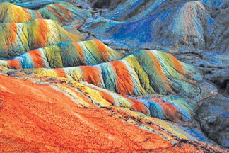
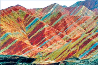
Danxia landform�s rock walls and cliffs are formed of red sandstone
and conglomerate. Research shows that about 100 million years ago, there
used to be a huge inland basin here. Water carried silt from the
surrounding mountains to the basin. As the result of global high
temperatures the basin dried up and in these arid conditions the
sediment oxidized and turned rust colour. Then some 70 million years ago
a 3,700-metre-thick red-coloured layer formed on the basin, known as the
chalk bed. On the top, there was a 1,300-metre-thick solid layer, i.e.,
layer of Cretaceous system, from which the peaks of Danxia Mountain
gradually took shape.Water flowing down through fissures cut through and
eroded the sedimentary rock, the slope broke and receded, leaving behind
the red fragmentary rocks we see today.Since 30 million years ago,
orogenic movement has lifted the whole basin many times. According to
experts, orogenic movement is still going on in the Danxia Mountain
area, with an average rise of 0.87 metre every 10,000 years over the
last 500,000 years. Beautiful Danxia Mountain is still growing.
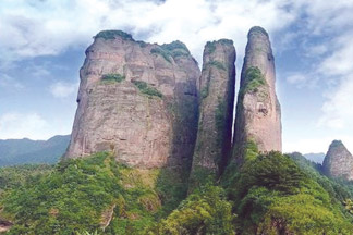
A very peculiar feature of Danxia landscape is the development of
numerous caves of various sizes and shapes. The caves tend to be shallow
and isolated, unlike true karst terrain where caves tend to form deep,
interconnecting networks.
Danxia landform included on World Heritage List
China�s unique Danxia landform was recognised as a natural world
heritage by the UNESCO World Heritage Committee, during its 34th meeting
in Brasilia, the capital of Brazil, on August 1, 2010.
�Danxia landform of China� is the general name of a serial nomination
for World Natural Heritage.
Danxia landform is the name given in China to define landscapes that
were developed under endogenous and exogenous forces on red sedimentary
beds. They are characterised by steep red cliffs, cave formations and
erosional landforms.
The rugged landscapes are rich in forests, flora and fauna species,
including about 400 being considered rare or threatened.
The inscribed site consists of six areas found in the sub-tropical
zone of south-west China. They are geographically and geologically
related, and collectively they are of precious value to Danxia
geomorphology in humid southeast China.
The six Danxia landform areas are: Lang Mountain in Hunan Province,
Mt. Danxia in Guangdong Province, Tainin in Fujian Province, Mt. Longhu
in Jiangxi Province, Chishui in Guizhou Province, and Mt. Jianglang) in
Zhejiang Province.
[Fast facts]
* The Danxia landform is named after Mount Danxia, one of the most
famous examples of the Danxia landform.
* Danxia landform is formed from red-coloured sandstones and
conglomerates of largely Cretaceous age.
* The landforms look very much like karst topography that forms in
areas underlain by limestones, but since the rocks that form Danxia are
sandstones and conglomerates, they have been called �pseudo-karst�
landforms.
* The Danxia landform refers to various landscapes found in southeast
and southwest China that �consist of a red bed characterized by steep
cliffs�; a unique type of petrographic geomorphology.
* As the landform gets older, valleys widen and one gets isolated
towers and ridges.
China�s seven most beautiful Danxia landscapes
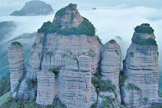
* Danxia Mountain (Guangdong Province): China�s red stone park.
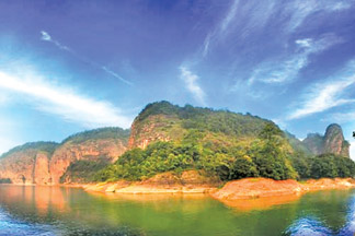
* Wuyi Mountain (Fujian Province): Second to none in southeast China.
* Dajin Lake (Fujian Province): Spectacle of � Danxia on water�.��
* Longhu Mountain (Jiangxi Province): Cradle of Taoism
* Langshan Mountain (Guangxi Zhuang Autonomous Region and Hunan
Province)
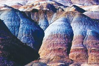
* Zhangye Danxia Landform (Gansu Province): Palaces Created by
nature.
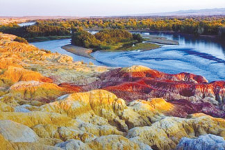
* Chishui Danxia Landform (Guizhou Province): Torrents tearing down
red cliffs.
These landscapes have been so named using the following criterion.
* Danxia landscape featured in the causes formation and ages and
geo-morphological characteristics.
* Aesthetic enjoyment in the resulting landscape patterns, lines,
colour, type, and combined with the surrounding landscape;
* Harmony with the natural landscape and cultural sight, and higher
cultural values.
* Totally well-preserved natural shape, without destructive
exploitation.
Facts and pix: Internet
|


")


