Seven wetlands in East under Environment Protected Areas
By Dhaneshi Yatawara
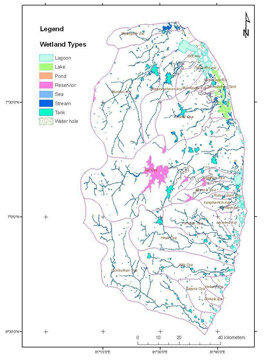
The Central Environment Authority(CEA) recently concluded a research
on wetlands in the Eastern Province to detect changes taking place in
the wetlands in the recent past on par with various development
activities that have been initiated. After studying 42 wetlands, CEA
officials have identified seven wetlands in the East to be declared as
Environment Protected Areas.
 |
|
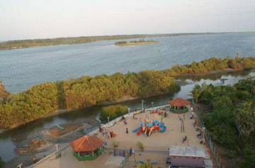
One of the wetlands |
 |
|
Ajith Gunawardena |
"This was a conclusion made after an extensive study in 42 wetlands
and when wetlands are declared as Environment Protected Areas it imposes
restrictions on conducting development activities and other
anthropogenic activities," said Ajith Gunawardena, Assistant Director of
the Research and Development unit of the CEA.
The East has a significant issue in connection with wetlands. Since
the Eastern Province is a heavily flood affected area, conserving the
existing wetlands is hugely beneficial. The objective of this project is
identification, mapping and change detection of important wetlands in
the South Eastern River basins of Sri Lanka using satellite data.
Locating prospective areas in the Eastern Province was the first step.
This project marks the base line tool for the declaration of
environmental protection areas under the National Environmental Act.
In this research around 18 biophysical parameters were used to
evaluate every wetland and statistical analysis was conducted to
prioritise the wetlands. The CEA initiated the project on Mapping and
Change Detection of Wetlands in South-Eastern River Basin Region in Sri
Lanka with the technical support and guidance from the Japan Aerospace
Exploration Agency (JAXA), University of Tokyo and Geo-informatics
Centre of the Asian Institute of Technology, Thailand under the theme
Space Application for Environment (SAFE).
Wetlands play an important role in maintaining a healthy environment
for human habitation. Under the RAMSAR convention six wetlands in Sri
Lanka are recognised as Wetlands of International Importance, with a
surface area of 198,172 hectares.
A wetland is generally an area which has soil that is saturated
(filled) with moisture, such as a swamp or marsh. Until quite recently,
the importance of wetlands was not identified in Sri Lanka. Most of the
time, they were drained and used as construction space and for garbage
dumps. Thto the entire eco-system.
 |
|
Technical support and guidance from
the Japan Aerospace Exploration Agency (JAXA) |
In addition, these perform a range of functions which are extremely
important.
Where uses are concerned, wetlands become useful in applications
related to water supply, medicinal herbs, salt, agriculture and tourism.
Important herbs such as 'Lunuwarana' and 'Neeramulliya' are taken from
marshes.
Marshes play a vital role in the mitigation (reducing) of floods,
purification of water and as a carbon sink where carbon dioxide is
accumulated. Specifically in the Eastern Province where floods have a
greater negative impact on the communities, economically and socially
flood mitigation is a key factor for the development of the area.
Wetlands are also considered the most biologically diverse of all
ecosystems, serving as home to a wide range of plant and animal life.
The biodiversity of wetlands, which supports a range of animal and plant
species, is very significant. For example, among the total inland
species with backbones in Sri Lanka, about 30 per cent are ecologically
dependent on wetlands. Among the migratory birds that visit Sri Lanka
annually, more than 50 per cent are directly dependent on wetlands for
food and shelter. Among the threatened ecosystems of Sri Lanka, wetlands
take high priority. A majority of the wetlands in Sri Lanka are facing
various threats due to harmful human activities such as encroachment,
habitat deterioration and degradation, pollution, direct loss and
exploitation of species, spread of invasive alien species and
destruction due to natural phenomena.
The UN Millennium Ecosystem Assessment determined that environmental
degradation is more prominent within wetland systems than any other
ecosystem on Earth. International conservation efforts are being used in
conjunction with the development of rapid assessment tools to inform
people about wetland issues.
  Carbon is the major nutrient cycled within the wetlands. Most
nutrients, such as sulfur, phosphorus, carbon, and nitrogen are found
within the soil of wetlands. Anaerobic and aerobic respiration in the
soil influences the nutrient cycling of carbon, hydrogen, oxygen, and
nitrogen and the solubility of phosphorus thus contributing to the
chemical variations in its water. A wetland system needs to be monitored
over time to in order to assess whether it is functioning at an
ecologically sustainable level or whether it is becoming degraded.
Degraded wetlands will suffer a loss in water quality, a high number of
threatened and endangered species, and poor soil conditions. Carbon is the major nutrient cycled within the wetlands. Most
nutrients, such as sulfur, phosphorus, carbon, and nitrogen are found
within the soil of wetlands. Anaerobic and aerobic respiration in the
soil influences the nutrient cycling of carbon, hydrogen, oxygen, and
nitrogen and the solubility of phosphorus thus contributing to the
chemical variations in its water. A wetland system needs to be monitored
over time to in order to assess whether it is functioning at an
ecologically sustainable level or whether it is becoming degraded.
Degraded wetlands will suffer a loss in water quality, a high number of
threatened and endangered species, and poor soil conditions.
Due to the large size of wetlands, mapping is an effective tool to
monitor wetlands. There are many remote sensing methods that can be used
to map wetlands. Remote-sensing technology permits the acquisition of
timely digital data on a repetitive basis. This repeat coverage allows
wetlands, as well as the adjacent land-cover and land-use types, to be
monitored seasonally and/or annually. Using digital data provides a
standardized data-collection procedure and an opportunity for data
integration within a geographic information system.
"Threats to wetlands are specific to each site. Yet we identified
that garbage dumping poses the greatest threat to many wetlands,"
Gunawardana added. Specifically to East it is crucial to keep the
lagoons, marshes and all the wetlands as it is to control the floods
that occurs with every rainy season and avoid disasters, said
Gunawardana. |


")


