The changing face of Colombo
by Weerasena Adhikari and E.A.C. Priyashantha
The City of Colombo being the Commercial Capital of Sri Lanka has
enormous potential to take off the development much greater than that of
other capital cities in the South Asian region. Due to political
upheavals that prevailed after Independence in 1948, the successive
governments have confronted with numerous hurdles in adopting
appropriate policies in every sector in the economy.
|
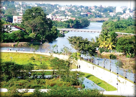
Wet Zone Park, Nawala |
If not for such drawbacks, the strategic location of Sri Lanka in
general and the City of Colombo in particular, located in close
proximity to vital international marine transportation routes, would
have grown dramatically as the key commercial hub of Asia.
The geopolitical climate in Sri Lanka is currently moving forward in
an unprecedented manner. It was also revealed that the City of Colombo
and all other provincial urban centres have lost many opportunities to
achieve sustainable urban development during the recently past.
Urbanisation
The estimated average rate of urbanisation in the country during the
period 2010 to 2020 would be in the range of three percent to four
percent per annum, while the country's annual population growth rate
will be less than 1.2 percent.
These trends suggest that around 60 percent of the population would
be living in urban areas by 2020.
With this trend, it is envisaged that the City of Colombo will
continue to grow as the prime Commercial Capital of Sri Lanka demanding
gradual shift of its administrative boundaries towards the hinterlands.
The present government's policy framework is directly involved in the
Urban Development Sector and adopted clear strategic actions to develop
the City of Colombo and other important and Regional Centres of Sri
Lanka.
Regeneration
A number of action projects were undertaken to upgrade the physical
condition of the City of Colombo with a face lifting program based on
the garden city concept. A lot of leisure activities for the public have
been created providing opportunities to witness the real freedom.
Parallel to this, the Ministry of Defense and Urban Development has
given clear directions to the relevant institutions to address the
Colombo's housing problem through new urban development strategies
considering the lessons learnt from the previous experience. The
regeneration of the city from its present context to face the new
development demands would transform the entire city profile into a
different scenario with a huge value addition to the properties while
addressing sustainability issues of development. In this context, it is
necessary to introduce the appropriate steps to strengthen the capacity
of the Colombo Municipal Council and other adjoining Local Authorities
in the Colombo metro region being the major stakeholder agencies. This
aspect too has is taken into account in the current Urban Regeneration
action plan.
The Colombo Municipal Council was established in January 1866 by the
British rulers along with introducing Provincial, District and Local
level administration systems in the country. After gaining independence
in 1948, the local political representatives took over the
administrative responsibilities of Colombo Municipal Council.
At the time of the establishment of Colombo Municipal Council, the
city population had been around 80,000 persons covering an area of 37.32
sq. km. Consisting of 47 Municipal Wards. These 47 Municipal Wards have
been clustered into Six (06) Municipal Districts namely, D1, D2A, D2B,
D3, D4 and D5 for the purpose of carrying out regular municipal services
to its citizens.
According to the population census in 1871, the population of the
Colombo was recorded as 98,847 persons with a density of 40 persons per
ha.
Thirty (30) years later in 1901, the city had a population of (54.69)
and the density was 56 persons per ha. In the year 1931, the population
had grown up to 284,155 with an increased density of 84 persons per ha.
In the census year 1963, the population had grown up to 511,639 persons
with a recorded density of 138 persons per ha. In the census year 2001,
the population of the City of Colombo was 642,163 with a density of 172
persons per ha. Hence, based on the annual growth rate in the city, the
city population is around the 706,379 persons in 2012.
According to the planning history of the City of Colombo, it was
evident that it was the British rulers who have initiated the first
Colombo city plan in the year 1921. According to the available
information Eminent British Town Planner Sir Patrick Geddes was the
first Town Planner to develop the concept of Garden City plan for
Colombo, which was known as the “Garden City of the East.” The emphasis
of this plan was to preserve the rural spirit in the city plan.
Subsequently, the second city plan of Colombo was initiated following
the enactment of the Town and Country Planning Ordinance in 1946.
For that purpose, internationally recognised British Town Planner,
Sir Patrick Abercrombie was invited to prepare a plan for city of
Colombo. Sir Abercrombie's plan of 1949 covered the Colombo Metropolitan
Region as a whole but did not translate into detailed proposals. The
plan emphasized on decentralisation of the cities’ functions and
creation of satellite towns around the city of Colombo. This plan also
did not make significant changes to the city structure.
City plan
The third city plan was known as Colombo Master Plan Project prepared
by a team of planners assigned under the United Nations Development
Programme (UNDP) in 1978.
|
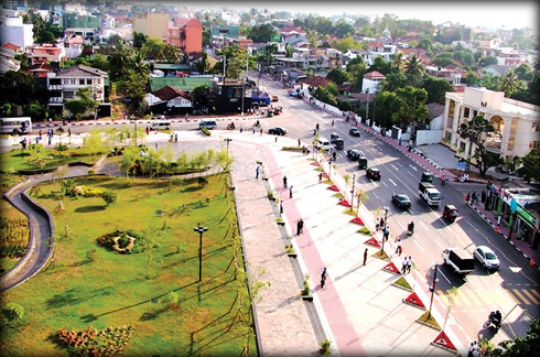
Nawala-Rajagiriya Road |
The main objective of Colombo Master Plan Project was the promotion
of balanced regional development and accelerated economic development of
the whole country. The Colombo Master Plan Project covered Colombo
District, Gampaha District and part of Kalutara District. The project
area was divided into two main regions such as the central sub region
and outer region.
The central sub region consisted of the city of Colombo and its
adjoining urban areas while the outer region consisted of towns outside
the Colombo central sub region.
The significant aspect of Colombo Master Plan Project was that it has
provided the basis for all the city planning programs implemented since
1978 in Colombo.
It is also important to record that formulation of the Urban
Development Authority Act and establishment of the Urban Development
Authority (UDA) in 1978 took place as a result of the policy influence
of the Colombo Master Plan Project.
Subsequent, city development plans have been prepared by the UDA in
close association with the Colombo Municipal Council and other relevant
government institutions to change the development pattern of the city of
Colombo.
As stated above, the City of Colombo Development Plan of 1985 was
prepared by the UDA based on the recommendations of the Colombo Master
Plan Project. This city development plan laid the foundation for
implementing zoning and building regulations of the City in keeping with
the rapid socio economic development trends in the country and in the
Western region.
Under this plan, the Colombo city area was divided into fourteen (14)
planning units for carrying out planning and development control
purposes. Subsequently, the above plan was amended in 1989 and cites as
City of Colombo Development Plan (Amendment), 1999.
Ten years later, this city development plan was again amended in the
year 2008 by the UDA and is being used for regulating the development
activities in the city.
UDA
Another important landmark in the city development plan of Colombo
undertaken by the UDA was the preparation of Colombo Metropolitan
Regional Structure Plan (CMRSP) in 1988.
The overall objective of the CMRSP was to design a strategic physical
plan and formulation of action projects in the CMR with a view to
achieve its set goals and objectives.
The plan initiates development of capital city territory, specially
the City of Colombo to grow as commercial hub Greater Kotte as
Administrative Capital.
It is the fact that the current development structure of Colombo has
had many influences by different city and regional development plans
prepared and implemented for Colombo and its Metropolitan Region in the
past as described above. The major changes that have taken place relate
to shifting of most of the administrative offices from the city of
Colombo to the new Administrative Capital of Sri Jayawardenapura Kotte
area concentrated in and around Battaramulla town, shifting of major
warehouses and industries to the new industrial towns of Peliyagoda,
Homagama and Horana, shifting of the Army Headquarters from the heart
of Colombo to Battaramulla and the redevelopment of Colombo Fort area by
replacing low rise buildings with high-rise commercial buildings and
offices.
Parallel to the above development changes, some significant
improvements in renovation and face lifting of all the colonial
buildings in Fort area, expansion of Colombo Harbour added significant
value to the development of the City of Colombo.
The Development in the hotels and banking sectors in the city also
have changed the city's landscape. Major improvement projects which have
been already implemented and those that are proposed in the roads,
drainage and sewerage sectors in the city also have contributed to the
new development demand in Colombo.
In addition to the above initiatives, the Metro Colombo Urban
Development Project implemented by the Ministry of Defense and Urban
Development in collaboration with UDA through the financial support of
the World Bank has initiated major improvement works in the drainage
system of the City of Colombo ant its environs by developing water
retention tanks, canals, improvement of access roads and recreational
areas aiming at flood control and total environmental improvement in the
city and its adjoining areas.
|
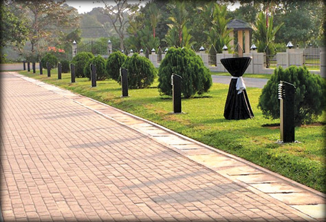
Parliament Ground walkway |
The impact of these strategic actions have paved the way to attract
major investment projects to the City of Colombo like Sangrilla Hotel,
and many high-rise mix developments and condominium apartments.
With all these recent major development programs, the citizens can
witness a total transformation of the development pattern of the city of
Colombo and its adjoining urban areas to be more environmental friendly,
safe and efficient. These changes would contribute to overall physical
and economic development in the Western Region and the Sri Lanka as a
whole.
The residential areas of the City of Colombo represent significant
characteristics in terms of level of income of the residents such as
high income residential areas, middle income residential areas, lower
middle income areas and low income areas.
Except in the low income areas, all the other residential areas of
the city of Colombo do have adequate level of urban basic services such
as water supply, sanitation, access roads, electricity and public
amenities etc.
Residential areas
Therefore more permanent nature of residential buildings with
increased densities exists in more established residential areas
mentioned above.
The low income areas represent different characteristics of
development constrained by inadequacy or total lack of urban basic
services and mostly improvised buildings with no secure land ownership.
Since recently, the low income areas of Colombo have been identified
as “Underserved Settlements” taking in to consideration of the specific
attributes of these settlements.According to the available literature,
the underserved settlements in Colombo have a long history of existence
dating back to the colonial era. The colonial rulers had brought
unskilled workers from the rural areas of Sri Lanka to Colombo to work
in the factories, harbour and other establishments in Colombo.
They had been provided rental houses with shared amenities
particularly in Colombo North locations such as Mattakkuliya, Mahawatta,
Lunupokuna, Bloemendhal and Kotahena.
The low income areas in these locations started to grow with the new
migration population as well as due to natural growth among original low
income population.
Continuation of the growth of low income population over the time
resulted in inadequacy of rental houses and therefore people began to
encroach marginal lands in the city such as marshy areas, railway and
canal reservation lands and abandoned paddy lands etc. and land set
aside for creating new settlements. These types of settlements are
mostly found in the Eastern and Southern parts of the city of Colombo.
Due to location constraints and legal and institutional barriers, it
was not possible to provide basic urban services to these newly created
settlements.
Hence, they continue to remain as underserved settlements. It was
evident that some major development interventions were undertaken by the
government institutions and the Colombo Municipal Council to improve
these underserved settlements in Colombo since the year 1978. |


")


